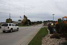
Dodgeville, Wisconsin
| Dodgeville | |
|---|---|
| City | |
 Dodgeville | |
| Coordinates: 42°57′48″N 90°7′52″W / 42.96333°N 90.13111°WCoordinates: 42°57′48″N 90°7′52″W / 42.96333°N 90.13111°W | |
| Country |
|
| State |
|
| County | Iowa |
| Established | 1827 |
| Founded by | Henry Dodge |
| Government | |
| • Mayor | Todd D. Novak (Republican) |
| • Clerk | Lisa A. Riley |
| Area | |
| • Total | 3.89 sq mi (10.1 km2) |
| • Land | 3.89 sq mi (10.1 km2) |
| • Water | 0 sq mi (0 km2) |
| Elevation[1] | 1,194 ft (364 m) |
| Population (2010)[2] | |
| • Total | 4,693 |
| • Estimate (July 1, 2014)[2] | 4,686 |
| • Density | 1,200/sq mi (470/km2) |
| Time zone | CDT (UTC-5:00) |
| • Summer (DST) | CST (UTC-6:00) |
| Zip code | 53533 |
| Area code(s) | 608 |
| Website |
cityofdodgeville |
Dodgeville is a city in and the county seat of Iowa County, Wisconsin, United States. The population was 4,693 at the 2010 census, making it the most populous city in the county. Dodgeville is part of the Madison Metropolitan Statistical Area. Its sister city is Oakham, Rutland, United Kingdom.
History
In 1827, Henry Dodge, his family, and about 40 miners began what would become the city of Dodgeville.[3] Dodge made a pact with the local Winnebago Indian leaders so he could build a cabin and smelter. The original community was made up of three separate settlements: "Dodgeville", "Dirty Hollow" and "Minersville".[3] A fourth settlement in the vicinity, Moon Spring, located near the intersection of the present Highway 18 bypass and Bennett Road flourished until the cholera epidemic in the early 1850s.
Dodgeville, which was named after Dodge,[4] grew slowly during its early years. It was incorporated as a village in the 1840s. Later a small "war" was fought with Mineral Point over which community would become the seat of Iowa County after Lafayette County was created. At the time, Mineral Point was the seat, because it had been centrally located in the 'old' Iowa County, stretching from the Wisconsin River in the north to the Illinois border in the south. It was eventually decided to move the County seat to Dodgeville because of its more central location in the 'new' Iowa County. Dodgeville then saw a population boom, and it became a center for mining and later, dairy product manufacturing and shipping. Miners from England flooded the city, and the area flourished. British and Cornish architecture is still visible in the city today. Dodgeville became the largest city in Wisconsin at the time as well as most of the Midwest north or St. Louis, and west of Cincinnati. The community's boom didn't last long though, and with the decline of mining its population was overtaken by rapidly growing cities like Chicago and Milwaukee. Several factors led to the decline in importance of mining, including the Black Hawk War, the California Gold Rush of 1849, the Civil War, and the emergence of farming, leading to Dodgeville's development as a business and agricultural center. Today the city is most commonly known for being the headquarters for the apparel company Lands' End.
Historical sites
Iowa County Courthouse
The Iowa County Courthouse was dedicated in 1859 and continues to serve as the seat of government in Iowa County, functioning as the oldest courthouse in the state. Several additions to the building have been added over the years, in keeping with the historic and classic architectural style of the original structure.
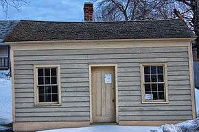
Dodge Mining Camp Cabin
This mining cabin, originally built circa 1828, is representative of the housing constructed by lead diggers at "Dodge's Camp" - the original lead mining claim of Colonel Henry Dodge and family. The Iowa County Historical Society restored the cabin and moved it to its present location on Fountain Street. It is one of Wisconsin's oldest structures and may be the last extant mining camp cabin from the days of the "Lead Rush" of 1827-1830.[5]
Spang's Opera House
The Opera House was built in the early stages of Dodgeville's development. It was demolished during the 1990s to build a convenience store at the intersections of Highway 23--Bequette, North and Spring Streets. The foundation walls of this structure were among the oldest stone structures in Dodgeville, dating from the 1840s. In the 1940s the lower level of the opera house was the first location of the Iowa County Dairy Cooperative, before the coop built a new structure near the intersection of Hwy. 191 and Section Line Road on the east side of Dodgeville. At one time the Opera House was in the center of a thriving business area, with several hotels in the immediate vicinity: The Cocking Hotel, the Wisconsin House, and the Western Hotel, all on North Main Street. Today, only the Western Hotel survives, and is not rental units.
Dodgeville Masonic Temple
Begun in 1928, construction was completed in 1930, with the building dedicated on May 13th of that year. This structure is among the last Masonic Temples built in Wisconsin that is still functioning as a Masonic Lodge. Dodgeville Lodge #119 dates to 1859. Today, the structure also houses a Masonic Museum for the Southwestern Wisconsin region. The Dodgeville Primitive Methodist Church stood on this site until the present Plymouth Congregational UCC structure was built in 1907.
Downtown
Downtown Dodgeville's historic buildings stretch six blocks along north and south Iowa Street.
Jones-Owens Mausoleum East Side Cemetery
The Jones and Owens family, prominent merchants in Dodgeville constructed a Mausoleum in the East Cemetery on East Division Street where several of the family members are entombed. Family mausoleums were quite common in larger urban areas in the late 19th century, but less common in smaller communities. The Jones and Owens mercantile business building is located on South Iowa Street and currently houses the Quality Bakery (since 1946), among other businesses. The Jones family mansion is located on North Main Street across from Plymouth UCC and the Owens family mansion is located on South Iowa Street near the intersection with Valley Street. Both structures are private dwellings.
Geography
Dodgeville is located at 42°57′48″N 90°7′52″W / 42.96333°N 90.13111°W (42.963373, -90.131161).[6]
According to the United States Census Bureau, the city has a total area of 3.89 square miles (10.08 km2), all of it land.[7]
Demographics
| Historical population | |||
|---|---|---|---|
| Census | Pop. | %± | |
| 1860 | 1,222 | — | |
| 1870 | 1,407 | 15.1% | |
| 1880 | 1,547 | 10.0% | |
| 1890 | 1,722 | 11.3% | |
| 1900 | 1,865 | 8.3% | |
| 1910 | 1,791 | −4.0% | |
| 1920 | 1,896 | 5.9% | |
| 1930 | 1,937 | 2.2% | |
| 1940 | 2,269 | 17.1% | |
| 1950 | 2,532 | 11.6% | |
| 1960 | 2,911 | 15.0% | |
| 1970 | 3,255 | 11.8% | |
| 1980 | 3,458 | 6.2% | |
| 1990 | 3,882 | 12.3% | |
| 2000 | 4,220 | 8.7% | |
| 2010 | 4,693 | 11.2% | |
| Est. 2015 | 4,652 | [8] | −0.9% |
2010 census
As of the census[2] of 2010, there were 4,693 people, 1,965 households, and 1,229 families residing in the city. The population density was 1,206.4 inhabitants per square mile (465.8/km2). There were 2,117 housing units at an average density of 544.2 per square mile (210.1/km2). The racial makeup of the city was 97.3% White, 0.5% African American, 0.3% Native American, 1.0% Asian, 0.2% from other races, and 0.8% from two or more races. Hispanic or Latino of any race were 1.8% of the population.
There were 1,965 households of which 33.3% had children under the age of 18 living with them, 47.0% were married couples living together, 11.2% had a female householder with no husband present, 4.4% had a male householder with no wife present, and 37.5% were non-families. 32.8% of all households were made up of individuals and 13.8% had someone living alone who was 65 years of age or older. The average household size was 2.35 and the average family size was 2.98.
The median age in the city was 37.8 years. 26.8% of residents were under the age of 18; 6.1% were between the ages of 18 and 24; 27.3% were from 25 to 44; 25.5% were from 45 to 64; and 14.3% were 65 years of age or older. The gender makeup of the city was 47.5% male and 52.5% female.
2000 census
As of the census[10] of 2000, there were 4,220 people, 1,751 households, and 1,131 families residing in the city. The population density was 1,178.5 people per square mile (455.1/km²). There were 1,831 housing units at an average density of 511.3 per square mile (197.5/km²). The racial makeup of the city was 98.06% White, 0.36% Black or African American, 0.02% Native American, 0.59% Asian, 0.05% Pacific Islander, 0.17% from other races, and 0.76% from two or more races. 0.43% of the population were Hispanic or Latino of any race.
There were 1,751 households of which 33.1% had children under the age of 18 living with them, 51.5% were married couples living together, 10.5% had a female householder with no husband present, and 35.4% were non-families. 30.9% of all households were made up of individuals, and 13.2% had someone living alone who was 65 years of age or older. The average household size was 2.34, and the average family size was 2.96.
In the city the population was spread out with 25.8% under the age of 18, 6.3% from 18 to 24, 31.5% from 25 to 44, 19.9% from 45 to 64, and 16.5% who were 65 years of age or older. The median age was 37 years. For every 100 females there were 89.3 males. For every 100 females age 18 and over, there were 85.0 males
The median income for a household in the city was $41,615, and the median income for a family was $50,755. Males had a median income of $32,738 versus $24,047 for females. The per capita income for the city was $20,962. About 2.7% of families and 5.3% of the population were below the poverty line, including 4.3% of those under age 18 and 16.0% of those age 65 or over.
Government
The foundations for the Iowa County Courthouse located at 222 North Iowa Street were laid in 1859, making it the state's oldest continuously active courthouse.[3]
The mayor of Dodgeville is Todd D. Novak.
Economy
Dodgeville was designated a National Mainstreet Program in 1991.[11]
As the seat of an agricultural county, the city's economy provides services for farmers. Dodgeville Agri-Service, Hennessey Implement, and Farmers' Saving Bank are several of the more important businesses in the city.
Dodgeville is home to the corporate headquarters of Lands' End, a global catalog and internet merchant of apparel and home products. Lands' End employs 6,000 people in its Dodgeville headquarters.
Dodgeville's original Wal-Mart, the second oldest in the state, was shuttered in favor of a Super-Center on January 19, 2007.
Education
The Dodgeville School District serves students from Dodgeville and the village of Ridgeway and comprises four schools - two elementary schools, one middle school, and one high school. One elementary school is located in Dodgeville, with the other in Ridgeway. The Dodgeville school covers pre-K through 4th grade, while the Ridgeway school also has a 5th grade. The middle school serves grades 6 through 8, and the high school 9 through 12.
The Dodgeville school district sports teams are known by the name of Dodgeville Dodgers, with the letter D used as the team symbol.
St. Joseph's Catholic school serves students in Kindergarten through 8th grade.
In the metropolitan building downtown SWATC adult education classes are offered.
Media
Dodgeville's weekly newspaper is the Dodgeville Chronicle, published every Wednesday. With a circulation of about 5,300, the newspaper serves Dodgeville and surrounding communities such as Highland, Linden, and Mineral Point.
Dodgeville is also served by the Wisconsin State Journal, published in Madison, and the Dubuque Telegraph Herald, Milwaukee Journal Sentinel, and Chicago Tribune.
Dodgeville's arts and cultural scene is represented by Voice of the River Valley magazine, A guide to people & events that inspire, inform and enrich life in the Lower Wisconsin and Sugar-Pecatonica River Basins.
Recreation
Military Ridge State Trail is a 40-mile (64 km) trail that runs from Dodgeville to Fitchburg, Wisconsin following the former Chicago and Northwestern Railroad paths (MRT). It is used for hiking, bicycling, snowmobiling, and cross country skiing. The original military road from Fort Howard in Green Bay to Fort Crawford in Prairie du Chien followed much of the same corridor in the 1820s through the 1840s and was the primary land route crossing the state.
Governor Dodge State Park is located on Highway 23, about 3 miles (4.8 km) north of Dodgeville. The park's development began in the late 1940s, followed by the development of Cox Hollow Lake in the 1950s. The Park is in the upper reaches of the Twin Parks watershed, a major soil and water conservation project in the area of the Lower Wisconsin River watershed.
Events
Every summer Dodgeville holds a "Farmer Appreciation Day" featuring a parade down Dodgeville's Iowa Street and a festival in Harris Park. The event, which takes place the third weekend of July, serves as a way for the people of Dodgeville to show appreciation for the farmers who are the backbone of the local economy. The parade features farming implements, fire trucks and ambulances, and floats constructed by area churches and businesses. The festival features cold BBQ sandwiches, music, rides, tractor pulls, and fireworks.
Every August, Lands' End hosts a four-day clearance sale in the Harris Park pavilion, drawing visitors in search of bargains.
Health care
In 1974, St. Joseph's Hospital and Dodgeville General Hospital merged to form Memorial Hospital In 2001, Memorial Hospital changed its name to Upland Hills Health Center. Later other structures were added to the hospital, which were eventually demolished to build the much larger existing Upland Hills Health Center. The Center now comprises a clinic, rehabilitation center, nursing home, and hospital. It is the largest hospital in southwestern Wisconsin, serving all of Iowa county.
Transportation
The Dodgeville Municipal Airport, built in 1967, was originally known as the Governor Dodge Quinn airport but was renamed Dodgeville Airport. Closed in 1989, it reopened as the Southwind Airport, a private airport, in 2002.[12]
The Aging & Disability Resource Center (ADRC) has a Care A Van that travels around Iowa county and to surrounding areas during the week. The bus is available on Tuesdays for people wanting to travel around Dodgeville. The bus is primarily for people aged 60 and over and people with disabilities. If space is available, anyone is welcome to ride the bus for a fee. People age 60 and over and people with disabilities are given the opportunity to make a donation.
All residents over the age of 60 and/or individuals with disabilities may use the Iowa County Aging & Disability Resource Center Volunteer Driver Escort program for non-emergency medical purposes only. Non-emergency medical appointments include; doctor appointments, dental appointments, picking up prescription/glasses or orthotics, counseling and appointments with the staff at the ADRC.
The Iowa County Taxi is a van that serves Dodgeville on Wednesdays and Fridays and Lamers Bus provides transportation from Green Bay to Dubuque, stopping in downtown Dodgeville.
Dodgeville Expressway, U.S. Highway 151, U.S. Highway 18, Wisconsin Highway 23 pass through the city.
Dodgeville no longer has rail service, but was once served by both the Chicago and Northwestern as well as the Illinois Central Rail Roads. The former Illinois Central freight depot still stands in downtown Dodgeville between Union, Iowa, Spring and Monitor Streets. The former C&NW passenger depot was relocated from North Dodgeville to the former Don Q Inn Supper Club and Motel property two miles north of Dodgeville in the 1970s and still stands there today. Dodgeville was the northern most terminus for the Illinois Central line from Freeport Illinois. The C&NW line extended from Madison to Dodgeville and then to points west and south, with its terminus in Platteville. The Illinois Central line to Dodgeville was removed in February 1942 and the rails were used in the construction of the Battleship Wisconsin which was commissioned during World War II and served into the Viet Nam era.
Notable people
- Glenn A. Abbey, U.S. diplomat
- Rev. Andrew Ambauen, SP Roman Catholic Priest and author, Rector of St. Joseph Parish, born in Switzerland and died at Holy Hill, Wisconsin, interred at St. Joseph Cemetery, Dodgeville
- Joseph J. Bennett, Member Wisconsin State Assembly 1876, operated the Slag Furnace built in 1876 that is preserved on East Spring Street in Dodgeville.
- Melancthon J. Briggs, Wisconsin State Assembly
- Col. Richard Carter, Civil War veteran and prominent area attorney
- Henry Dodge, First Territorial Governor of Wisconsin for whom the City of Dodgeville was named
- William D. Dyke, former U.S. vice presidential candidate
- Thomas Evans, Wisconsin State Assembly
- Homer Fieldhouse, landscape architect
- Francis Gehon, member of the Iowa Territorial Legislature
- Bradley M. Glass, Illinois state legislator and lawyer
- Archie Hahn, Gold medal Olympic sprinter in the 1904 and 1906 Olympics
- Albert S. Hearn, Civil War Veteran and former Editor of the Dodgeville Chronicle
- Steve Hilgenberg, Wisconsin State Assembly
- Thomas Jenkins, Wisconsin State Assembly
- Hon. Aldro Jenks, Iowa County Circuit Judge
- John J. Jones, Union Army general
- Samuel Reese, Founder Dodgeville Bank
- Luman Mastin Strong, Founder Strong's Bank, operated 1881-1984, now the BMO Harris Bank of Dodgeville
- Joel Whitman, Wisconsin State Senate
- Platt Whitman, Wisconsin State Assembly
- John "Weenie" Wilson, Hall of Fame football, basketball, and baseball coach
References
- ↑ U.S. Geological Survey Geographic Names Information System: City of Dodgeville
- 1 2 3 "American FactFinder". United States Census Bureau. Retrieved 24 October 2015.
- 1 2 3 Johnson, Cindy (August 18, 1999). "Dodgeville History". Wisconsin Local History Network. Retrieved 2009-05-01.
- ↑ Gannett, Henry (1905). The Origin of Certain Place Names in the United States. Govt. Print. Off. p. 107.
- ↑ "Dodge Mining Camp Cabin | Iowa County Historical Society". Iowa County Historical Society. Retrieved 2016-01-15.
- ↑ "US Gazetteer files: 2010, 2000, and 1990". United States Census Bureau. 2011-02-12. Retrieved 2011-04-23.
- ↑ "US Gazetteer files 2010". United States Census Bureau. Retrieved 2012-11-18.
- ↑ "Annual Estimates of the Resident Population for Incorporated Places: April 1, 2010 to July 1, 2015". Retrieved July 2, 2016.
- ↑ "Census of Population and Housing". Census.gov. Retrieved June 4, 2015.
- ↑ "American FactFinder". United States Census Bureau. Retrieved 2008-01-31.
- ↑ Archived July 4, 2007, at the Wayback Machine.
- ↑ "Southwind Airport". AirNav. Retrieved 23 October 2015.
External links
| Wikivoyage has a travel guide for Dodgeville, Wisconsin. |
- City of Dodgeville
- Dodgeville Chamber of Commerce
- Sanborn fire insurance maps: 1894 1899 1905 1915
Municipalities and communities of Iowa County, Wisconsin, United States | ||
|---|---|---|
| Cities | 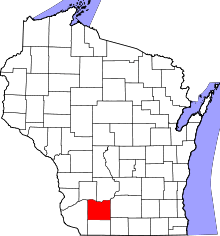 | |
| Villages | ||
| Towns | ||
| CDP | ||
| Unincorporated communities | ||
| Ghost towns | ||
| Footnotes | ‡This populated place also has portions in an adjacent county or counties | |