Mocha, Yemen
| Mocha | |
|---|---|
 Mocha Location in Yemen | |
| Coordinates: 13°19′N 43°15′E / 13.317°N 43.250°E | |
| Country |
|
| Governorate | Taiz Governorate |
| Elevation | 43 ft (13 m) |
| 16,794 | |
| Time zone | Yemen Standard Time (UTC+3) |
Mocha or Mokha (Arabic: المخا al-Mukhā Yemeni pronunciation: [elˈmoχæ]) is a port city on the Red Sea coast of Yemen. Until Aden and Hodeida eclipsed it in the 19th century, Mocha was the principal port for Yemen's capital Sana'a.
Overview
Mocha is famous for being the major marketplace for coffee (Coffea arabica) from the 15th century until the early 18th century. Even after other sources of coffee were found, Mocha beans (also called Sanani or Mocha Sanani beans, meaning from Sana'a) continued to be prized for their distinctive flavor—and remain so even today.[1] The coffee itself did not grow in Mocha, but was transported from places inland to the port in Mocha, where it was shipped abroad.
According to the Portuguese Jesuit missionary Jerónimo Lobo, who sailed the Red Sea in 1625, Mocha was "formerly of limited reputation and trade" but since "the Turkish assumption of power throughout Arabia, it has become the major city of the territory under Turkish domination, even though it is not the Pasha's place of residence, which is two days' journey inland in the city of Sana'a."[2] Lobo adds that its importance as a port was also due to the Ottoman law that required all ships entering the Red Sea to put in at Mocha and pay duty on their cargoes.
History
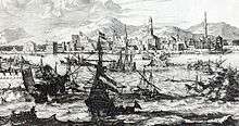
Mocha reached its zenith in the 17th century, owing to its trade in coffee. The city boasted of a stone wall that enclosed a citadel, as well as a labyrinth of thatched huts that surrounded the wall from without. Of these, some four-hundred were Jewish households who occupied in trade.[3] Passing through Mocha in 1752 and 1756, Remedius Prutky found that it boasted a "lodging-house of the Prophet Muhammad, which was like a huge tenement block laid out in many hundred separate cells where accommodation was rented to all strangers without discrimination of race or religion." He also found a number of European ships in the harbor: three French, four English, two Dutch, and one Portuguese.[4] In the 18th century, a plague decimated half of the city's population, from which time the city never really recovered.[3]
English, Dutch, French and Danish East India companies maintained factories at Mocha, which remained a major emporium and coffee exporting port until the early 19th century. In August 1800 Phoenix visited. William Moffat, her captain, took the opportunity to prepare a chart of the mouth of the Red Sea.
In December 1820, HMS Topaze and ships and troops belonging to the British East India Company attacked the North and South Forts, destroying them. The action was in pursuit of British demands on the government of the city. A decade and a half later, Ibrahim Pasha of Egypt would also attack the city and destroy its fortified wall closest to the sea, as well as its citadel.[3] However, by that time, Mocha's trade in its country's precious commodity of coffee grains (Coffea arabica) had already been supplanted by Ethiopia which was the principal trader of this commodity to North Africa and which sold for a third of the price of the same coffee imported from Arabia.[5]

.jpg)
Diplomat Edmund Roberts visited Mocha in the 1830s. He noted that Turkish "rebels" possessed Mocha. The Turks took it over after they left Egypt while being disgruntled with the rule of Muhammad Ali of Egypt. These "rebels," consisting of confederates throughout Arabia, had banded together under one leader named Turkie ben al Mas.[6] Jacob Saphir who visited the city in 1859 wrote about seeing many houses that were vacant of dwellers, although the Turkish governor still dwelt there with a band of soldiers, collecting taxes from local traders and ships visiting the harbor.[3] When the British took control over Aden, the port in Mocha fell into disuse, being replaced by Aden. The general destruction of the city was still prominent as late as 1909, when German explorer and photographer, Hermann Burchardt, wrote of the city Mocha as he saw it: “This card will reach you from one of the most godforsaken little places in Asia. It exceeds all my expectations, with regard to the destruction. It looks like a city entirely destroyed by earthquakes, etc.”[7]
Mocha was among the population centers in southern Yemen taken over by the Houthis during their military offensive in March 2015.[8]
At present, Mocha is no longer utilized as a major trade route and the current local economy is largely based upon fishing and small amounts of tourism. The village of Mocha was officially relocated 3 kilometres (1.9 mi) west along the Red Sea shore to accommodate the building and demolition of several coastal highways.
Climate
Köppen-Geiger climate classification system classifies its climate as hot desert (BWh).
| Climate data for Mocha | |||||||||||||
|---|---|---|---|---|---|---|---|---|---|---|---|---|---|
| Month | Jan | Feb | Mar | Apr | May | Jun | Jul | Aug | Sep | Oct | Nov | Dec | Year |
| Average high °C (°F) | 31.2 (88.2) |
31.5 (88.7) |
33.4 (92.1) |
35.4 (95.7) |
37.6 (99.7) |
38.8 (101.8) |
39.5 (103.1) |
38.9 (102) |
37.6 (99.7) |
35.7 (96.3) |
33.2 (91.8) |
31.4 (88.5) |
35.35 (95.63) |
| Daily mean °C (°F) | 26.7 (80.1) |
27.1 (80.8) |
28.8 (83.8) |
30.6 (87.1) |
32.7 (90.9) |
34 (93) |
34.6 (94.3) |
34 (93) |
33 (91) |
31 (88) |
28.9 (84) |
27.2 (81) |
30.72 (87.25) |
| Average low °C (°F) | 22.3 (72.1) |
22.7 (72.9) |
24.2 (75.6) |
25.9 (78.6) |
27.8 (82) |
29.2 (84.6) |
29.7 (85.5) |
29.1 (84.4) |
28.4 (83.1) |
26.3 (79.3) |
24 (75) |
23 (73) |
26.05 (78.84) |
| Average precipitation mm (inches) | 5 (0.2) |
2 (0.08) |
4 (0.16) |
4 (0.16) |
2 (0.08) |
1 (0.04) |
8 (0.31) |
14 (0.55) |
22 (0.87) |
6 (0.24) |
2 (0.08) |
5 (0.2) |
75 (2.97) |
| Source: Climate-Data.org, altitude: 3m[9] | |||||||||||||
Sister cities
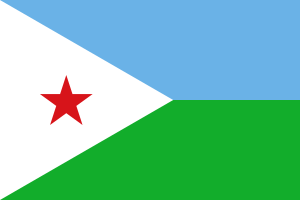 Tadjoura, Djibouti
See also
References
- ↑ "Yemen coffee, pearls upon trees". Yemen Times. Archived from the original on July 26, 2011. Retrieved 4 August 2011.
- ↑ Donald M. Lockhart, translator, The Itinerário of Jerónimo Lobo (London: Hakluyt Society, 1984), p.88
- 1 2 3 4 Iben Safir, (vol. 1), Jacob Saphir, Lyck, 1866, pp. 110a– 111a (Hebrew)
- ↑ J.H. Arrowsmith-Brown, translator and editor, Prutky's Travels to Ethiopia and Other Countries (London: Hakluyt Society, 1991), pp.363f
- ↑ Johann Ludwig Burckhardt (John Lewis Burckhardt), Travels in Nubia 1819.
- ↑ Roberts, Edmund (1837). Embassy to the Eastern Courts of Cochin-China, Siam, and Muscat. New York: Harper & Brothers. p. 346.
- ↑ Michael Friedländer, Hermann Burchardt: Mitteilungen aus seinen letzten Briefen (Messages from his last letters), published in Journal: Ost und West (Illustrated monthly magazine for all of Judaism), issue 2 / February 1910, Berlin, p. 108 (German).
- ↑ "Key waterway under threat as Houthi militiamen advance". Saudi Gazette. 24 March 2015. Retrieved 25 March 2015.
- ↑ "Climate: Mocha - Climate graph, Temperature graph, Climate table". Climate-Data.org. Retrieved 4 October 2013.
Further reading
- Published in the 19th century
- William Milburn (1813), "Mocha", Oriental Commerce, London: Black, Parry & Co., OCLC 6856418
- Jedidiah Morse; Richard C. Morse (1823), "Mocha", A New Universal Gazetteer (4th ed.), New Haven: S. Converse
- Josiah Conder (1834), "Mocha", Dictionary of Geography, London: T. Tegg
- John Macgregor (1844). "Mocha". Commercial Statistics. London: C. Knight and Co.
- Published in the 20th century
-
 Chisholm, Hugh, ed. (1911). "Mokha". Encyclopædia Britannica. 18 (11th ed.). Cambridge University Press. p. 651.
 - "Mocha". The New Student's Reference Work. 1914.
External links
| Wikimedia Commons has media related to Mocha. |
Coordinates: 13°19′N 43°15′E / 13.317°N 43.250°E