Moher Tower
| Moher Tower | |
|---|---|
| Irish: Túr an Mhothair | |
 Moher Tower | |
 | |
| Former names | Moher Uí Ruis or Moher Uí Ruidhin |
| General information | |
| Status | ruin |
| Type | signaling/watchtower |
| Location | Hag's Head, County Clare |
| Country | Ireland |
| Coordinates | 52°56′54″N 9°28′04″W / 52.948212°N 9.467861°WCoordinates: 52°56′54″N 9°28′04″W / 52.948212°N 9.467861°W |
| Estimated completion | early 19th century |
Moher Tower (Irish: Túr an Mhothair; historically Moher Uí Ruis or Moher Uí Ruidhin)[1] is the stone ruin of an old watchtower which stands on Hag's Head, at the southern end of the Cliffs of Moher, located in County Clare, Ireland.
History
The current tower stands close to the site of an earlier fortification, known as Mothar or Moher, a promontory fort. This earlier fortification stood until at least 1780 and is mentioned in an account from John Lloyd's a Short Tour Of Clare (1780).[2] This earlier fortification was demolished in 1808 to provide material for a new telegraph tower. This was built nearby, as a lookout/signaling tower during the Napoleonic Wars (1803–1815).[1][3] Similar towers were built along Atlantic coasts to counter fears of invasion during Napoleon's reign in Europe.
Construction and use
The building is a single, nearly square, tower with two rectilinear bartizans protruding from the top of its eastern wall, and one from the western wall, which faces the Atlantic Ocean. The original structure appears to have incorporated a fireplace on at least 2 floors, and a dry stone roof which has since mostly caved in. The roof itself has a short parapet which appears to have been more for protection from falling than to have served any defensive purpose.
In summer the tower ruin is occupied by the many choughs and similar birds native to the area. The tower is sometimes used as a refuge by visitors to the Cliffs of Moher who become stranded on the southern cliff path during storms that whip in off the Atlantic.
Gallery
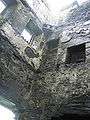 Inside Moher Tower
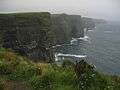 Moher Tower is on the furthest cliff visible
References
| Wikimedia Commons has media related to Moher Tower. |
- 1 2 Archaeology of the Burren: Prehistoric Forts and Dolmens in North Clare by Thomas Johnson Westropp. Journal of the Royal Society of Antiquaries of Ireland Vol. xxxv., Consecutive Series; Vol. xv., Fifth Series (1905). Retrieved: 24 February 2012.
- ↑ Clare Library – Lloyd's Tour of Clare, 1780 – Burren, Mohar, Liscanor Bay
- ↑ Kelly, Eamonn (2009). The Cliffs of Moher. Matthew Kelly. ISBN 0-9561746-0-4.