Monk (Montreal Metro)
Monk | |||||||||||
|---|---|---|---|---|---|---|---|---|---|---|---|
 | |||||||||||
| Location |
6750 and 6805 Monk Boulevard, Montreal Quebec, Canada | ||||||||||
| Coordinates | 45°27′05″N 73°35′35″W / 45.45139°N 73.59306°WCoordinates: 45°27′05″N 73°35′35″W / 45.45139°N 73.59306°W | ||||||||||
| Operated by | Société de transport de Montréal | ||||||||||
| Connections | |||||||||||
| Construction | |||||||||||
| Depth | 18.3 metres (60 feet), 18th deepest | ||||||||||
| Architect | Blais & Bélanger | ||||||||||
| History | |||||||||||
| Opened | 3 September 1978 | ||||||||||
| Traffic | |||||||||||
| Passengers | 1,279,012 entrances in 2011, 62nd of 68 | ||||||||||
| Services | |||||||||||
| |||||||||||
Monk is a station on the Green Line of the Montreal Metro rapid transit system operated by the Société de transport de Montréal (STM). The station is located in the Ville-Émard district of the borough of Le Sud-Ouest in Montreal, Quebec, Canada.[1]
Art and Architecture
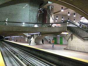
The station structure was designed by Blais & Bélanger and features many works of art, including the large sculpture Pic et Pelle by artist Germain Bergeron. Monk also features many balconies that overlook the main station below, however they have been closed for the safety of the visually impaired.
Germain Bergeron considered many different ideas for the public art for this station. His first concept was to create a series of flying saucers that were suspended from the roof of the station, and were to move with the wind generated by passing trains. However, this was deemed too dangerous by authorities, and the idea was cancelled.
The current two giant statues of workers constructing the Metro were to have been accompanied by a third, representing a foreman, but this idea was judged superfluous and scrapped.
Origin of the name
The station is named for boulevard Monk, itself named to honour Sir James Monk (1745-1826). Monk was a prosecutor who served on Quebec's vice admiralty court from 1778 to 1788 and subsequently became Montreal's chief justice from 1793 to 1820. Alternatively the boulevard and the station were named for Frederick D. Monk, an attorney who along with Joseph-Ulric Émard purchased land belonging to the Davidson family in order to develop it, the area became Ville-Émard.[2][3]
Connecting bus routes
| Société de transport de Montréal | |||
|---|---|---|---|
| Route | Service Times | Map | Schedule |
| |
All-day | Map | Schedule |
| |
All-day, Weekends before 12:00AM | Map | Schedule |
| |
Overnight | Map | Schedule |
Nearby points of interest
- Centre hospitalier Ville Émard
- Douglas Hospital[4][5][6]
- École Dollard-des-Ormeaux
- École St-Jean-de-Matha
- École Honoré-Mercier
References
- ↑ Monk Station
- ↑ http://www.metrodemontreal.com/green/monk/history.html
- ↑ http://ville-emard.com/pages/histoire/index-histoire.html#creation
- ↑ Douglas Hospital Contact
- ↑ Douglas Hospital Map
- ↑ Getting to the Douglas, Station Monk (15 minutes walk)
External links
- Monk Station- Official site
- Montreal by Metro www.metrodemontreal.com - photos and information
- 2011 STM System Map