Mont-Orford National Park
| Mont-Orford National Park | |
|---|---|
|
IUCN category II (national park) | |
 | |
 | |
| Location | Orford, Memphrémagog Regional County Municipality, Quebec, Canada |
| Nearest city | Magog, Quebec |
| Coordinates | 45°20′00″N 72°13′00″W / 45.33333°N 72.21667°WCoordinates: 45°20′00″N 72°13′00″W / 45.33333°N 72.21667°W[1] |
| Area | 58.37 square kilometres (22.54 sq mi) |
| Established | 1938 |
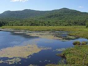
Mont-Orford National Park is a park in Orford, Quebec, Canada that is maintained and protected by the Sépaq.[2]
Geography
The park is located immediately north of Magog in the Eastern Townships tourist region of the province. It encompasses several mountain peaks, among which are Mont Orford, Mont Giroux (Pic aux Corbeaux), Mont Alfred Desrochers, Mont Chauve, and the Massif des Chênes.
Recreation
The park is open year-round. Popular summer activities in the park include camping, hiking, swimming, cycling, canoeing, kayaking, pedalos, row boating, rock climbing, paddle surfing, and wildlife watching. The most popular winter sport in the park is alpine skiing, with cross-country skiing, snowshoeing, snow walking, and Ski-Vel (wheelchair skiing).[3]
References
- ↑ Reference number 374630 of the Commission de toponymie du Québec (French)
- ↑ "Registre des aires protégées du Québec" (PDF) (in French). Ministère du Développement durable, de l’Environnement et des Parcs. p. 3. Retrieved 7 August 2014.
- ↑ "Parc national du Mont-Orford". Retrieved 7 August 2014.
External links
This article is issued from Wikipedia - version of the 11/19/2016. The text is available under the Creative Commons Attribution/Share Alike but additional terms may apply for the media files.