Mont-Tremblant National Park
| Mont-Tremblant National Park | |
|---|---|
| (French) Parc national du Mont-Tremblant | |
|
IUCN category II (national park) | |
 | |
| Location | Les Laurentides, Matawinie and Antoine-Labelle RCMs, Quebec, Canada |
| Nearest city | Mont-Tremblant |
| Coordinates | 46°26′00″N 74°21′00″W / 46.43333°N 74.35000°WCoordinates: 46°26′00″N 74°21′00″W / 46.43333°N 74.35000°W |
| Area | 1,510.10 km2 (583.05 sq mi) |
| Established | March 1, 1981 |
| Governing body | SEPAQ |
Mont-Tremblant National Park (French: Parc national du Mont-Tremblant) is a provincial park in Canada located north of the town of Mont-Tremblant, and the village of Saint-Donat and Saint-Côme, in the administrative regions of Laurentides and Lanaudière, in Quebec, in Canada.
It is the second largest provincial park in Quebec after Kuururjuaq National Park and it is the oldest provincial park in Quebec. It takes its name from Mont-Tremblant.
The main objective of the park is to protect an area representing the natural province of Southern Laurentians.
Several summer and winter activities include cross-country skiing, snowshoeing, short and long hiking hut, canoe lake and river kayaking, mountain biking, backcountry camping and swimming in lakes, such as Lake Lauzon clear water.
The park is managed by the Quebec government and its Société des établissements de plein air du Québec (SÉPAQ).
Geography
Location
This park covers 1,510.1 square kilometres (583.1 sq mi) and is located in the northeast of Mont-Tremblant and extends east to the north of Saint-Côme. Its territory is located in the regional county municipality (MRC) of Les Laurentides, Antoine-Labelle and Matawinie. The park includes eight municipalities and three unorganized territories. It is bounded on the north by the Rouge-Matawin Wildlife Reserve (réserve faunique Rouge-Matawin) and on the east by the Zec Lavigne.
The park is divided into three main areas, namely the valleys of the Devil's River, the Pimbina Creek and the Assomption River. Devid sector is accessible by the highway 15 and route 117 from Montreal; or by route 323 from Ottawa. The Pimbina sector is accessible via the route 125 from Saint-Donat. The "L'Assomption" sector is accessible through Saint-Côme. It is also possible to access to the park by La Macaza, by Labelle and by Saint-Michel-des-Saints.
The park lies within the eastern forest-boreal transition ecoregion.[1]
Climate
The climate of Mont-Tremblant park is characterized by moderately warm summers and cold winters. Precipitation is relatively abundant all year. Mount Tremblant and Le Carcan both have a stratigraphy due to altitude. Given the size of the park, it also has a cooling north .[2]
Template:Meteo statement
Geology and soil science
The entire park is located in the Grenville Province, the most recent of the Canadian Shield geological province. The rock is composed of gneiss and granulites. The passage of Ice Age strongly influenced its territory rounded hilltops and valleys surcreusant.
The glaciers also left a layer of till with variable size. There are sand deposits along the rivers and lakes. Organic deposits are rare and are found north of Lake Cypress and along some lakes.[3]
Hydrography

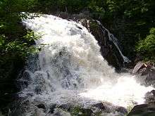
The park is divided in three sub-watersheds, namely the Rouge (through the Diable River) of The Assumption and the Matawin. Streams and forms lakes are greatly influenced by the shortcomings of the Canadian Shield. There are over 400 lakes in the park, including the largest, Lake Cypress, is 9 square kilometres (3.5 sq mi). Most lakes are located in the northern part of the park, the southern portion having a rugged landscape. The position of the park at the head of several watersheds ensures good water quality in streams.[4]
History
The Algonquin called the massive "Manitonga Soutana" (Mountain of Spirits or the Devil). They claimed that the mountain emitted rumblings and swayed under their feet.[5] Logging began in the region in the 1850s. This is the 12 the "Park of Trembling Mountain" was created after the project to install a sanatorium, which will never see the day. Unlike vision of "preservationist" was prevailing in United States and Canada and that exempted the park from exploitation, the province preferred a vision "conservationist" which promoted a reasonable use of the natural resources.[6] That's what made that logging remained in the park until 1981. The park, originally an area of 60 square kilometres (23 sq mi) and enlarged of 3,108 square kilometres (1,200 sq mi) in 1925.[7]

In 1938, an American named Joe Ryan makes a ski resort on the Mont-Tremblant and makes change provincial legislation to include the use of public park and place of recreation. A research station opened at Lake Monroe in 1948 and an initial public camping born at Lake Chat 1958, which marked the kickoff for the creation of several recreational facilities in the valleys of the Devil and northern Saint-Donat. In 1961, the park changed its name to "Parc du Mont-Tremblant".[4]
In 1977, the province changed the philosophy of conservation and adopted the "Law on Parks". This new law precluded commercial and industrial exploitation of natural resources in the parks. The old parks were given priority and the park was granted the status of "recreation park" in 1981, with the exception of an area of 242 square kilometres (93 sq mi) which was included in park in 1990. The northern half of the park became in turn the Rouge-Matawin Wildlife Reserve (réserve faunique Rouge-Matawin). The government revived further consultations in 1998, who produced minor boundary changes and the change in status for "conservation park" in 2000.[4] He became the "Mont-Tremblant National Park" after abandoning the status of recreation park by the province in 2001.
Natural Heritage
Wildlife
There are in the park 40 species of mammal. The more easily observable are the moose, the deer, the eastern wolf, the red fox, the black bear, the hare, the red squirrel, the Canadian beaver, the muskrat, the river otter and the mink. Eleven of these species are likely to be designated threatened or vulnerable.[4]
The diversity of birds is much larger with 194 species, including 25 of warblers. Included are grouse, buntings, thrushes, nuthatches, woodpeckers and jays. It includes also some the great horned owl, the barred owl, the winged hawk, the hawk and the osprey. The park is also used as a staging area for the Canada goose.[4] Of these species, only the bald eagle is considered vulnerable.
The park also includes seven species of reptiles and fourteen species of amphibians, mostly associated with the aquatic environment. It contains, among others the bullfrog, the green frog, the newt, the water snake, the wood turtle and the painted turtle. The wood turtle is listed as vulnerable in Quebec; and water snakes and pickerel frog are likely to be designated threatened or vulnerable.[4]
We finally found 29 species of fishes in the park, the main species being the brook trout, which prefers headwater lakes oxygen, and pike, which prefers warmer waters.[4]
Wolf
The eastern wolf is a subspecies of wolf frequenting the park and the emblem of the park. It is estimated to have in the park four or five packs and a population of 35 individuals. The park wolves mainly hunt beaver, moose and deer, which constitute the major part of their diet.[8]
Flora

The park is part of the climax area of sugarbush to yellow birch. The tops of the hills and the valley Macaza, on the north, have the start of the range of fir yellow birch. The "Carcan" (Straitjacket) and Mount Tremblant has meanwhile a succession of forest land from the sugar maple to balsam fir.
The main tree species are the sugar maple, the red maple, the yellow birch, the white birch, the beech, the aspen, the balsam fir, the white spruce, the red spruce and the black spruce. It also includes individuals of hemlock, basswood and red oak which are at the northern limit of their distribution areas.[4]
The park has 9 plants likely to be designated threatened or vulnerable, most of them located in the Lake Monroe. With the exception of Hieracium robinsonii and Listeria australis, watching other plants back 40 years and requires an update.[4]
Activities
Summer and fall
- Swimming
- Golfing
- Canoeing
- Canoe camping
- Fishing
- Hiking
- Backpacking
- Cycling
Winter
- Snowshoeing
- Backcountry skiing (overnight trips)
- Snow walking
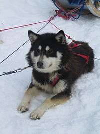
- Dog sled
See also
- List of birds of Mont-Tremblant National Park
- National Parks of Canada
- List of National Parks of Canada
- List of Quebec national parks
- Rouge-Matawin Wildlife Reserve
- Mont-Tremblant, municipality
- Zec Lavigne, neighbourg zec
- Laurentides, administrative region
- Lanaudière, administrative region
- Les Laurentides Regional County Municipality
- Antoine-Labelle Regional County Municipality
- Matawinie Regional County Municipality
References
- ↑ Olson, D. M, E. Dinerstein; et al. (2001). "Terrestrial Ecoregions of the World: A New Map of Life on Earth". BioScience. 51 (11): 933–938. doi:10.1641/0006-3568(2001)051[0933:TEOTWA]2.0.CO;2.
- ↑ Société de la Faune et des Parcs (2000). "Plan directeur: Parc du Mont-Tremblant" (PDF). p. 1. Retrieved October 25, 2008.
- ↑ "Blueprint: Parc du Mont-Tremblant" (PDF). Society of Wildlife and Parks. 2000. p. 2. Retrieved October 25, 2008.
- 1 2 3 4 5 6 7 8 9 1
- ↑ "Topos on the web: Mont Tremblant". Retrieved October 22, 2008.
- ↑ "Blueprint: Parc du Mont-Tremblant" (PDF). Society of Wildlife and Parks. 2000. p. XVI, XVII. Retrieved October 22, 2008.
- ↑ "Mission Life: History". sepaq.com. Retrieved November 2, 2008.
- ↑ "The wolf emblem of the National Park of Mont-Tremblant". Journal of the Park: Parc national du Mont-Tremblant. 2007–2008. p. 5.
External links
| Wikimedia Commons has media related to Parc national du Mont-Tremblant. |