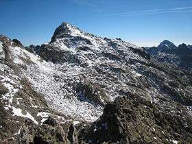
Monte Clapier
| Monte Clapier Mont Clapier | |
|---|---|
 | |
| Highest point | |
| Elevation | 3,045 m (9,990 ft) [1] |
| Coordinates | 44°06′58″N 7°25′09″E / 44.11611°N 7.41917°ECoordinates: 44°06′58″N 7°25′09″E / 44.11611°N 7.41917°E |
| Geography | |
 Monte Clapier Mont Clapier Location of Monte Clapier in the Alps. | |
| Location |
Piedmont, Italy Provence-Alpes-Côte d'Azur, France |
| Parent range | Maritime Alps |
| Climbing | |
| First ascent | 1832, Luigi Giovanni Fecia Cossato, approaching from Entracque[2] |
Monte Clapier (French: Mont Clapier) is a mountain in the Maritime Alps, on the boundary between the province of Cuneo (Piedmont, northern Italy) and the French region of Provence-Alpes-Côte-d'Azur.
Geography
It is part of the Mercantour massif.
Monte Clapier is home to the southernmost glacier in the Alps, located on the Italian side at some 40 km from the sea. Furthermore, it is the southernmost mountain in the Alps exceeding 3000 meters in height.
Geology
Geologically, the mountain is formed by granitoid gneiss, with outcrops of amphibolic agmatites (granitoid migmatites).
Climbing
It may be climbed from the Refuge Nice in around two-and-a-half to three hours,[3] initially northward along a narrow path towards the Lacs de Mont Clapier, then eastward along a cairned route (no path visible) across rough, bouldered ground.
View
The view is extensive stretching from the Mediterranean to the south to the high Alps to the northeast. Monte Viso is prominent to the north and 4000m peaks like the Matterhorn, Monte Rosa and the Weissmies,[4] and even Corsica,[5] are visible on clear days.
See also
References
- ↑ http://www.viewfinderpanoramas.org/panoramas/EUR/CLAPIER-N.gif
- ↑ Lorenzo Bagnoli, Quando non esistevano i satelliti. La cartografia alpina del Capitano Cossato, in "Le rocce della scoperta", Glauco Brigatt, Genoa 2009
- ↑ Personal experience and quoted time from staff at the Refuge Nice.
- ↑ http://www.viewfinderpanoramas.org/panoramas/EUR/CLAPIER-N.gif
- ↑ http://www.viewfinderpanoramas.org/panoramas/EUR/CLAPIER-S.gif
Maps
- Italian official cartography (Istituto Geografico Militare - IGM); on-line version: www.pcn.minambiente.it
- French official cartography (Institut Géographique National - IGN); on-line version: www.geoportail.fr
Bibliography
- Villani, Nanni (April 2002). Monte Argentera, tre metri sotto i tremila e trecento, in Piemonte Parchi - speciale Cime Tempestose. Regione Piemonte.