Mont Yamaska
| Mont Yamaska | |
|---|---|
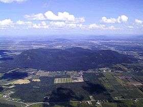 Aerial Shot of Mount Yamaska | |
| Highest point | |
| Elevation | 411 m (1,348 ft) |
| Coordinates | 45°27′25″N 72°52′19″W / 45.45694°N 72.87194°WCoordinates: 45°27′25″N 72°52′19″W / 45.45694°N 72.87194°W |
| Geography | |
| Location | Saint-Paul-d'Abbotsford, 12 kilometers northwest of Granby, Quebec, Canada |
| Parent range | Monteregian Hills |
| Topo map | NTS 031H/07 |
| Geology | |
| Age of rock | Early Cretaceous |
| Mountain type | Intrusive stock |
Mont Yamaska is part of the Monteregian Hills in southern Quebec. Its summit stands 411 m (1,348 ft) above sea level. This mountain is largely covered with deciduous forest dominated by sugar maple. Some apple orchards are raised on lower slopes.
Geology
Mont Yamaska is composed of igneous rock and hornfels. The igneous rock is mostly mafic with much gabbro, essexite, and a titanium-rich pyroxenite. Mont Yamaska might be the deep extension of a vastly eroded ancient volcanic complex, which was probably active about 125 million years ago.[1] The mountain was created when the North American Plate moved westward over the New England hotspot,[1] along with the other mountains of the Monteregian Hills that form part of the Great Meteor hotspot track.
See also
References
- 1 2 A Hundred-Million Year History of the Corner Rise and New England Seamounts Retrieved on 2007-08-01
External links
This article is issued from Wikipedia - version of the 11/10/2015. The text is available under the Creative Commons Attribution/Share Alike but additional terms may apply for the media files.