Monteregian Hills
| Monteregian Hills | |
|---|---|
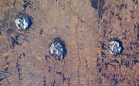 Three of the central Monteregian hills (from left: Mont Saint-Hilaire, Mont Rougemont and Mont Yamaska) viewed from space. | |
| Highest point | |
| Peak | Mont Megantic |
| Elevation | 1,105 m (3,625 ft) |
| Geography | |
| Country | Canada |
| Province | Quebec |
| Range coordinates | 45°29′N 73°02′W / 45.48°N 73.04°WCoordinates: 45°29′N 73°02′W / 45.48°N 73.04°W |
| Geology | |
| Age of rock | Early Cretaceous |
The Monteregian Hills (French: Collines Montérégiennes) is a linear chain of isolated hills in Montreal and Montérégie, between the Laurentians and the Appalachians.
Etymology
The first definition of the Monteregian Hills came about in 1903 when Montreal geologist Frank Dawson Adams began referring to Mount Royal (Latin, Mons Regius) and hills of similar geology in the Saint Lawrence Lowlands as the "Royal Mountains" (French: montagnes royales).[1] Other hills in the chain included Mont Saint-Bruno, Mont Saint-Hilaire, Mont Saint-Grégoire, Mont Rougemont, Mont Yamaska, Mont Shefford, and Mont Brome.
It was only later that Mont Mégantic,[2] the Oka Hills, as well as the Saint-André and d'Iberville formations, were added to the list.[3]
Geology
Each hill in the chain consists of an erosional remnant of Cretaceous intrusive igneous rock and associated hornfels, which are more resistant to weathering than the surrounding sedimentary rock. All of the hills have dark-coloured mafic rock such as gabbro and essexite; some also have large areas of pulaskite, syenite, and other light-coloured rock.
The Monteregian Hills are part of the Great Meteor hotspot track, formed as a result of the North American Plate sliding westward over the long-lived New England hotspot,[4] and are the eroded remnants of intrusive stocks. These intrusive stocks have been variously interpreted as the feeder intrusions of long extinct volcanoes, which would have been active about 125 million years ago,[5][6] or as intrusives that never breached the surface in volcanic activity.[7] The lack of an obvious track west of the Monteregian Hills may be due either to failure of the plume to penetrate the Canadian Shield, to the lack of recognizable intrusions, or to strengthening of the plume when it approached the Monteregian Hills region. However, there is evidence the hotspot track extends northwestwards, including epeirogenic uplift, mantle velocity anomalies and kimberlitic volcanic features (e.g. the Attawapiskat, Kirkland Lake and Lake Timiskaming kimberlite fields) that become older away from the Monteregian Hills.[8]
The shallow, rocky sandy loam soils of the summits are mostly covered in forest. Where the underlying rock is rich in olivine, as over large areas of Mont Saint-Bruno and Mont Rougemont, these soils are classed as dystric brunisol. Podzol tends to develop over rock which lacks olivine, although many of these podzols lack an eluvial (Ae) horizon. Lower slopes are covered with aprons of gravel or sand. The sandy soils are usually podzols with classic Ae development; they often have subsoil hardpan and are undesirable for agriculture. The free-draining gravels are preferred for apple orchards, which grow in thermal belts where cold air can drain to the valley floor.
| Name | Height | Age | Coordinates | Location |
|---|---|---|---|---|
| Oka Hills | 249 metres (817 ft)[9] | n/a | 45°28'N, 74°5'W | Oka |
| Mount Royal | 233 metres (764 ft) | 118-138 myr | 45°30'23"N, 73°35'20"W | Montreal |
| Mont Saint-Bruno | 218 metres (715 ft) | 118-136 myr | 45°33'1"N, 73°19'09"W | Saint-Bruno-de-Montarville |
| Mont Saint-Hilaire | 411 metres (1,348 ft) | 135 myr | 45°33'8"N, 73°9'3"W | Mont-Saint-Hilaire |
| Mont Saint-Grégoire | 251 metres (823 ft) | 119 myr | 45°21'29"N, 73°09'08"W | Mont-Saint-Grégoire |
| Mont Rougemont | 381 metres (1,250 ft) | 137 myr | 45°28'36"N, 73°03'17"W | Rougemont |
| Mont Yamaska | 416 metres (1,365 ft) | 120-140 myr | 45°27'25"N, 72°52'19"W | Saint-Paul-d'Abbotsford |
| Mont Shefford | 526 metres (1,726 ft) | 120-130 myr | 45°21'49"N, 72°37'33"W | Shefford |
| Mont Brome | 553 metres (1,814 ft) | 118-138 myr | 45°16'59"N, 72°37'59"W | Bromont |
| Mont Mégantic | 1,105 metres (3,625 ft) | 128-133 myr | 45°27'20.5"N, 71°9'7.6"W | Notre-Dame-des-Bois |
Gallery
 Four of the Monteregian Hills in the late fall
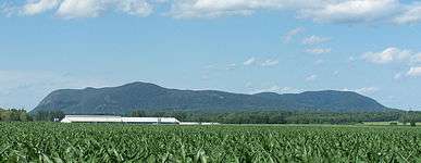 Mont Saint-Hilaire from the south
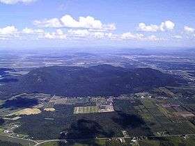 aerial view of Mont Yamaska
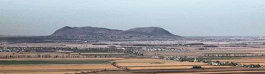 Mont Rougemont as seen from Mt. Saint-Grégoire
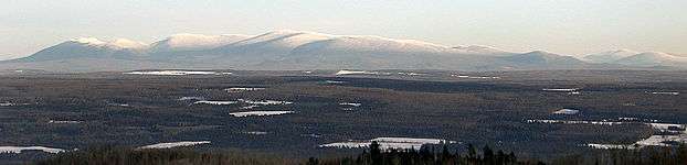 Mont Mégantic as seen from the Stoke Mountains
See also
External links
| Wikimedia Commons has media related to Monteregian Hills. |
- (French) Les collines montérégiennes Geologic information about the chain
References
- ↑ Reference number 76975 of the Commission de toponymie du Québec (French)
- ↑ Tomas Feininger and Alan K. Goodacre, The distribution of igneous rocks beneath Mont Mégantic (the easternmost Monteregian) as revealed by gravity, Can. J. Earth Sci./Rev., 40(5): 765-773 (2003) http://pubs.nrc-cnrc.gc.ca/cgi-bin/rp/rp2_abst_e?cjes_e03-022_40_ns_nf_cjes (abstract)
- ↑ Bédard, Pierre. "La province géologique montérégienne : l'état des connaissances" (pdf) (in French). Communauté métropolitaine de Montréal. p. 6. Retrieved 22 August 2014.
Avec le progrès des connaissances géologiques, le mont Mégantic, les roches intrusives d'Iberville, d'Oka, et de Saint-André se sont progressivement ajoutés à la liste.
- ↑ http://www.nature.com/nature/journal/v446/n7134/fig_tab/nature05675_F2.html Inferred track of the Great Meteor hotspot. Retrieved on 2007-10-04
- ↑ A Hundred-Million Year History of the Corner Rise and New England Seamounts http://www.oceanexplorer.noaa.gov/explorations/05stepstones/background/geologic_history/geologic_history.html Retrieved on 2007-08-01
- ↑ The Monteregian Hills: Igneous Intrusions, http://geoscape.nrcan.gc.ca/montreal/heritage_e.php#mont Natural Resources Canada, Geoscape Montreal, 2006-07-24
- ↑ http://www.mcgill.ca/gault/sainthilaire/natural/geology/ Geology of Gault Nature Reserve, Mont St. Hilaire, McGill University
- ↑ Darbyshire, Fione A.; Eaton, David W.; Frederiksen, Andrew W.; Ertolahti, Leila (2007). "New insights into the lithosphere beneath the Superior Province from Rayleigh wave dispersion and receiver function analysis": 4.
- ↑ "Mont Bleu". Peakbagger.com. Retrieved 20 August 2014.