Montchaton
| Montchaton | |
|---|---|
|
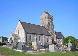
The church of Saint-Georges | |
 Montchaton | |
|
Location within Normandy region  Montchaton | |
| Coordinates: 49°00′34″N 1°29′50″W / 49.0094°N 1.4972°WCoordinates: 49°00′34″N 1°29′50″W / 49.0094°N 1.4972°W | |
| Country | France |
| Region | Normandy |
| Department | Manche |
| Arrondissement | Coutances |
| Canton | Coutances |
| Intercommunality | Communauté de communes de Montmartin-sur-Mer |
| Government | |
| • Mayor (2008–2014) | Gérard Paisnel |
| Area1 | 6.50 km2 (2.51 sq mi) |
| Population (2006)2 | 362 |
| • Density | 56/km2 (140/sq mi) |
| Time zone | CET (UTC+1) |
| • Summer (DST) | CEST (UTC+2) |
| INSEE/Postal code | 50339 / 50660 |
| Elevation |
5–61 m (16–200 ft) (avg. 51 m or 167 ft) |
|
1 French Land Register data, which excludes lakes, ponds, glaciers > 1 km² (0.386 sq mi or 247 acres) and river estuaries. 2 Population without double counting: residents of multiple communes (e.g., students and military personnel) only counted once. | |
Montchaton is a former commune in the Manche department in Normandy in north-western France. On 1 January 2016, it was merged into the new commune of Orval-sur-Sienne.[1]
Heraldry
 |
The arms of Montchaton are blazoned : Per bend sinister vert and sable, a salmon contourny 'leaping' and a roman helmet argent crested gules, and on a chief gules a cross moline argent. |
See also
References
- ↑ Arrêté préfectoral 25 November 2015 (French)
| Wikimedia Commons has media related to Montchaton. |
This article is issued from Wikipedia - version of the 6/28/2016. The text is available under the Creative Commons Attribution/Share Alike but additional terms may apply for the media files.