Montelabbate
| Montelabbate | |
|---|---|
| Comune | |
| Comune di Montelabbate | |
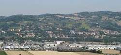 | |
 Montelabbate Location of Montelabbate in Italy | |
| Coordinates: 43°51′N 12°47′E / 43.850°N 12.783°ECoordinates: 43°51′N 12°47′E / 43.850°N 12.783°E | |
| Country | Italy |
| Region | Marche |
| Province / Metropolitan city | Province of Pesaro e Urbino (PU) |
| Frazioni | Montelabbate, Apsella, Osteria Nuova, Farneto, Ripe |
| Area | |
| • Total | 19.6 km2 (7.6 sq mi) |
| Elevation | 65 m (213 ft) |
| Population (Dec. 2004) | |
| • Total | 5,876 |
| • Density | 300/km2 (780/sq mi) |
| Demonym(s) | Montelabbatesi |
| Time zone | CET (UTC+1) |
| • Summer (DST) | CEST (UTC+2) |
| Postal code | 61025 |
| Dialing code | 0721 |
| Website | Official website |
Montelabbate is a comune (municipality) in the Province of Pesaro e Urbino in the Italian region Marche, located about 60 kilometres (37 mi) northwest of Ancona and about 12 kilometres (7 mi) southwest of Pesaro. As of 31 December 2004, it had a population of 5,876 and an area of 19.6 square kilometres (7.6 sq mi).[1]
The municipality of Montelabbate contains the frazioni (subdivisions, mainly villages and hamlets) Montelabbate, Apsella, Osteria Nuova, Farneto, and Ripe.
Montelabbate borders the following municipalities: Colbordolo, Monteciccardo, Pesaro, Sant'Angelo in Lizzola, Tavullia, Urbino.
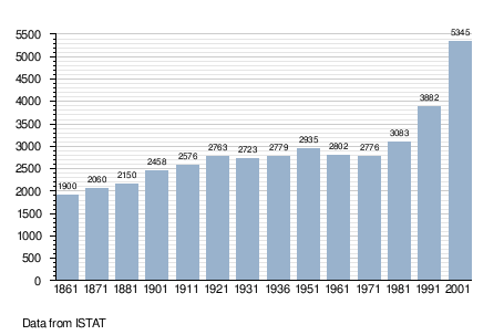
Demographic evolution
References
External links
This article is issued from Wikipedia - version of the 1/31/2015. The text is available under the Creative Commons Attribution/Share Alike but additional terms may apply for the media files.