Monti Sabatini

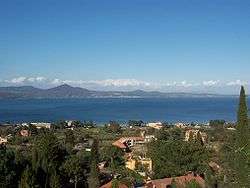
The Monti Sabatini is a geologic region in Lazio, central Italy, a remnant of intense volcanism which started ca. 600,000 years ago, mainly with pyroclastic and maar forming eruptions which continued until 100,000 years ago. The mountains are part of the Lazio's Anti-Apennines. Included between the Monti Sabatini is the Lake Bracciano, which is a volcanotectonic depression formed about 3.7 Ma, and the Lake Martignano. The sedimentary base of the Sabatini complex lies buried under 200 m (660 ft) of volcanic ash and rocks.
The highest point is Monte Rocca Romana (a postcaldera stratocone), at 612 m (2,008 ft).
Other mountains in the area include Monti della Tolfa, Monte Soratte, and more southwards, by the Monti Cornicolani.
See also
External links
| Provinces |  | |
|---|---|---|
| Lakes | ||
| Mountains |
| |
| Geography | ||
| Politics | ||
Categories | ||
Coordinates: 42°10′N 12°15′E / 42.167°N 12.250°E