Mota Lava
| Native name: <span class="nickname" ">Mwotlap | |
|---|---|
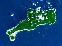 Mota Lava, viewed from space. On the southwest point one may see the islet of Ra. | |
 | |
| Geography | |
| Location | Pacific Ocean |
| Coordinates | 13°42′S 167°39′E / 13.7°S 167.65°ECoordinates: 13°42′S 167°39′E / 13.7°S 167.65°E |
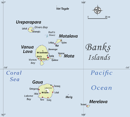
| Archipelago | Vanuatu, Banks Islands |
| Area | 24 km2 (9.3 sq mi) |
| Administration | |
|
Vanuatu | |
| Province | Torba Province |
| Largest settlement | Lahlap |
| Demographics | |
| Population | 1640 (2009) |
| Pop. density | 67 /km2 (174 /sq mi) |
Mota Lava or Motalava (coordinates 13°42′S 167°39′E / 13.7°S 167.65°E) is the fourth largest island in the Banks Islands of Vanuatu, after Gaua, Vanua Lava and Ureparapara, with an area of 24 km2 (9.3 sq mi).
It is the largest and highest (411 m or 1,348 ft) of the eastern chain of islands. 270 meters (886 ft) off its southern coast, attached by high corals that one can wade through at low tide, is the islet of Ra, with an area of 50 ha (120 acres).
The 2009 census figures[1] give a population of 1640 inhabitants (Mota Lava + Ra), yielding a population density of 67 per km².
Name and language
In early texts and maps of the 19th century, the island of Mota Lava was designated as Saddle Island, due to the island's distinctive profile seen from a boat.
The habit of designating the island as Mota Lava was then borrowed by 19th-century missionaries from the neighbouring language Mota. The inhabitants of Mota Lava call their own island Mwotlap (pronounced [ŋmʷɔtˈlap]).
Mwotlap also designates the language spoken by the inhabitants of Mota Lava. It is the most widely spoken of the languages in the Banks Islands, with about 2,100 speakers.
An earlier attempt to transcribe the native name, both for the island and the language, yielded a form Motlav.
History
Mota Lava was first sighted by Europeans during the Spanish expedition of Pedro Fernández de Quirós, from 25 to 29 April 1606. The island’s name was then charted as Lágrimas de San Pedro (“St. Peter's Tears”, in Spanish).[2]
Geology
Mota Lava is composed of at least five basaltic stratovolcanoes. Two of the cones, Vetman and Tuntog, are well-preserved. Vetman is a pyroclastic cone in the centre of the island with a breached summit crater. At the southwest end of the island, Tuntog is a composite cone with a 500 meters (1,640 feet) wide crater.
Geochemical analysis shows that the island's lava has a similar composition to that from nearby Mota and Ureparapara, as well as lava from the south of the country, but differs from material erupted in central Vanuatu. The latter region has been affected by the subduction of a submerged, extinct island arc complex called the D'Entrecasteaux Zone.
Transportation
The island is served by Mota Lava Airport.
References
- ↑ "2009 National Census of Population and Housing: Summary Release" (PDF). Vanuatu National Statistics Office. 2009. Retrieved October 11, 2010.
- ↑ Kelly, Celsus, O.F.M. La Austrialia del Espíritu Santo. The Journal of Fray Martín de Munilla O.F.M. and other documents relating to the Voyage of Pedro Fernández de Quirós to the South Sea (1605-1606) and the Franciscan Missionary Plan (1617-1627) Cambridge, 1966, p.39, 62.
- Sources
- "Motlav". Global Volcanism Program. Smithsonian Institution.
- David W. Peate; Julian A. Pearce; Chris J. Hawkesworth; Howard Colley; Caroline M. H. Edwards; Kei Hirose (1997). "Geochemical Variations in Vanuatu Arc Lavas: the Role of Subducted Material and a Variable Mantle Wedge Composition". Journal of Petrology. 38 (10): 1331–1358. doi:10.1093/petrology/38.10.1331. Retrieved 2007-05-10.
External links
- Tourism site with map
- Site of the linguist Alexandre François, including an introduction to the culture of Mota Lava and its language (Mwotlap), as well as photos, maps, songs, a myth, and a traditional story
| Provinces of Vanuatu |  | ||||||||||||||||||||||
|---|---|---|---|---|---|---|---|---|---|---|---|---|---|---|---|---|---|---|---|---|---|---|---|
| Islands and islets | |||||||||||||||||||||||