Mount Adagdak
| Mount Adagdak | |
|---|---|
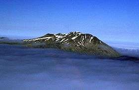 Mount Adagdak in 2000 | |
| Highest point | |
| Elevation | 2,001 ft (610 m) [1] |
| Coordinates | 51°59′16″N 176°35′30″W / 51.98778°N 176.59167°WCoordinates: 51°59′16″N 176°35′30″W / 51.98778°N 176.59167°W [1] |
| Geography | |
 Mount Adagdak | |
| Parent range | Aleutian Range[1] |
| Topo map | USGS Adak C-2 |
| Geology | |
| Age of rock | Pleistocene[1] |
| Mountain type | Stratovolcano[1] |
| Volcanic arc/belt | Aleutian Arc |
Mount Adagdak is a Pleistocene age stratovolcano on the northernmost extremity of Adak Island in the Aleutian Islands, Alaska. Located about 1,180 miles (1,900 km) from Anchorage, the mountain is located about 1.4 kilometers (0.9 mi) south of Cape Adagdak, for which it was named in 1948 by the United States Geological Survey.
John Hunter of Quicklaunch has twice proposed the use of Mount Adagdak's western slope as the emplacement site for a light-gas gun to launch small payloads into orbit for use at ISS.[2]
See also
References
- 1 2 3 4 5 "Adagdak". Global Volcanism Program. Smithsonian Institution. Retrieved 2009-01-16.
- ↑ Livingston, David (January 15, 2010). "Dr. John Hunter". The Space Show. Retrieved 2011-05-22.
External links
This article is issued from Wikipedia - version of the 1/2/2016. The text is available under the Creative Commons Attribution/Share Alike but additional terms may apply for the media files.