Mount Gabi
| Mount Gabi | |
|---|---|
|
Survey map that lead to the discovery of Mt Gabi | |
| Highest point | |
| Elevation | 300 m (980 ft) |
| Geography | |
| Location | Sea floor, 50 kilometres from Augusta, Western Australia |
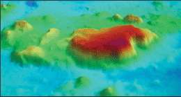
Coordinates: 35°15′0″S 115°07′0″E / 35.25000°S 115.11667°E Mount Gabi is an underwater mountain, similar to a guyot, that was discovered in 2006, fifty kilometres off the coast of Augusta near the south-western tip of Western Australia.[1] It lies at a depth of one thousand metres, rising three hundred metres from the sea floor and is five kilometres wide. It was named by Professor Charitha Pattiaratchi, the chief scientist on the mission.
The formation is very similar to the large sandstone formation named Uluru which has been a popular destination for tourists in the Northern Territory of Australia for many years.
The Surveyor, a National Research vessel, accidentally made the discovery using a swath mapper while investigating continental shelf processes between the Great Australian Bight and Cape Leeuwin.
The discovery was made by Cameron Buchanan, a multibeam sonar specialist from Geoscience Australia, the Australian national agency for geoscience research and geospatial information. At the time he was designing a swath survey after taking advantage of a last minute detour to the planned schedule.
References
- ↑ Geoscience Australia (31 May 2006). "Survey detour discovers underwater mountain". Retrieved 21 October 2010.