Mount Idaho (mountain)
| Mount Idaho | |
|---|---|
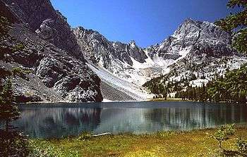 Mount Idaho and Merriam Lake | |
| Highest point | |
| Elevation | 12,065 ft (3,677 m) |
| Prominence | 1,065 ft (325 m) [1] |
| Parent peak | Borah Peak |
| Coordinates | 44°06′22″N 113°46′40″W / 44.106047°N 113.777803°WCoordinates: 44°06′22″N 113°46′40″W / 44.106047°N 113.777803°W |
| Geography | |
 Mount Idaho Custer County, Idaho, U.S. | |
| Parent range | Lost River Range |
| Topo map | USGS Elkhorn Creek |
| Climbing | |
| Easiest route | Scramble, class 3 |
Mount Idaho, at 12,065 feet (3,677 m) above sea level is the seventh highest peak in Idaho and the sixth highest in the Lost River Range. The peak is located in Salmon-Challis National Forest in Custer County. It is 2.2 mi (3.5 km) south of Borah Peak, its line parent, and 2.8 mi (4.5 km) northwest of Leatherman Peak. Merriam Lake is in the basin to the northeast of the peak.[2][3][4]
References
- ↑ "Mount Idaho, Idaho". Peakbagger.com. Retrieved January 2, 2013.
- ↑ "The 100 Highest Peaks". Idaho: A Climbing Guide. Retrieved January 2, 2013.
- ↑ "Mount Idaho". SummitPost.org. Retrieved January 2, 2013.
- ↑ "Idaho 12ers Home Page". Idaho Summits. Retrieved January 2, 2013.
This article is issued from Wikipedia - version of the 2/25/2016. The text is available under the Creative Commons Attribution/Share Alike but additional terms may apply for the media files.