Mount Nitai
| Mount Nitai | |
|---|---|
| Har Nitai | |
 Har Nitai viewed from Mount Arbel | |
| Highest point | |
| Elevation | ? |
| Coordinates | 32°49′32.22″N 35°29′12.04″E / 32.8256167°N 35.4866778°ECoordinates: 32°49′32.22″N 35°29′12.04″E / 32.8256167°N 35.4866778°E |
| Geography | |
 Mount Nitai | |
Mount Nitai (Hebrew: הר נתאי, Har Nitai) is a mountain in Israel; it is situated west of the Sea of Galilee and north of the city of Tiberias and is due west of Mount Arbel. Har Nitai is named after Nittai of Arbela. The cliffs of both Nitai and Arbel are visible when looking southwest from Capernaum on the shore of the Sea of Galillee.
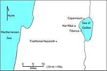
A valley with a stream through it separates Har Nitai from Har Arbel. Atop Har Nitai is a grove of trees and the ruins of an ancient settlement, identified as the ancient village of Arbel[1] (cf. Hosea 10:14). The eastern boundary of the site is marked by the ruins of an ancient wall, and approximately 80 metres east of the wall is a sheer drop-off, or cliff. Ancient residents may have built the wall for safety-reasons (for example, to prevent their children from having access to the cliff); or perhaps to enclose a defendable area, bounded by the wall and the cliff, to repel attackers. Excavation must be performed and evidence unearthed to interpret the site’s history.
| Wikimedia Commons has media related to Mount Nittai. |
References
- ↑ The New Encyclopedia of Archaeological Excavations in the Holy Land, vol. 1, p. 87-88.