Mount Arbel
| Mount Arbel | |
|---|---|
 | |
| Highest point | |
| Elevation | 181 m (594 ft) above sea level |
| Prominence | 380 m (1,250 ft) |
| Coordinates | 32°49′26″N 35°30′25″E / 32.824°N 35.507°ECoordinates: 32°49′26″N 35°30′25″E / 32.824°N 35.507°E |
| Geography | |
 Mount Arbel | |
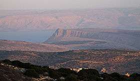
Mount Arbel (Hebrew: הר ארבל, Har Arbel) is a mountain in The Lower Galilee near Tiberias in Israel, with high cliffs, views of Mount Hermon in the Golan Heights, trails to a cave-fortress, and ruins of an ancient synagogue. Mt. Arbel sits across from Mount Nitai; their cliffs were created as a result of the Jordan Rift Valley and the geological faults that produced the valleys.
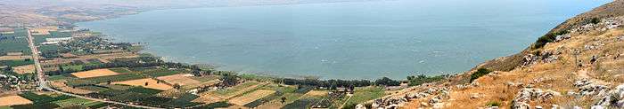
There are four villages on the mountain: Kfar Zeitim, Arbel, Kfar Hittim, and Mitzpa. The peak, at 181 metres above sea level (380 metres above the surrounding area), dominates the surroundings (much of the area is below sea level) and from the lookout atop the mountain, almost all of the Galilee into the Golan Heights including Safed, Tiberias and most of the Sea of Galilee, is visible.
History
.jpg)
Nearby are the ruins of an ancient Jewish settlement with a synagogue from the fourth century CE with pews and columns.
Dug into the mountain itself are a number of cave dwellings, expanded from natural caves. There are documented Jewish cliff dwellings dating back to the Second Temple period in the area. The extant fortification walls protecting some of these caves are from the 17th century and were built by Ali Bek, son of the Druze emir Fakhr ad-Din al-Ma'ani. Josephus writes about how Herod the Great, with the help of Roman soldiers, defeated some of the last rebels who supported the Hasmonean king Antigonus and had taken refuge in the cliffs of Mt Arbel.[1][2][3]
It is also Josephus who, writing about himself in the third person, tells us about his deeds at the beginning of the First Jewish–Roman War in the year 66 CE:
- "Moreover, he [Josephus] built walls about the caves near the lake of Gennesar, which places lay in the lower Galilee".[4]
Nature reserve and national park
The area was declared a nature reserve in 1967, covering 1400 dunams.[5] The national park (8509 dunams) includes most of Nahal Arbel, that begins near Eilabun and empties into the Sea of Galilee near Migdal. The reserve covers the immediate area around the cliff.[6]

On the south side of the cliff, there is a gradual prolonged climb through agricultural and pasture land and from the peak there is a steep 400 meters drop. From here there are metal handholds driven into the rock to aid those who want to make the climb down to the valley below. Below that are a series of switchbacks that eventually lead to the Bedouin village of Hamaam.
Mt. Arbel, with its 110 metre vertical drop, is the only known mountain in Israel to serve as a base jumping site.[7] A hike to the top of Mount Arbel from the south is included in the Israel National Trail, and an approach from the west is part of the Jesus Trail; the trails converge temporarily at the peak.
References
- ↑ "Arbel". Bible Walks. Retrieved 14 December 2015.
- ↑ The Times of Israel article about the cliffs of Arbel (2013)
- ↑ National Parks leaflet
- ↑ Josephus Flavius. "The Wars of the Jews, Book II, ch. 20, paragraph 6". Retrieved 5 February 2016.
- ↑ "List of National Parks and Nature Reserves" (PDF) (in Hebrew). Israel Nature and Parks Authority. Retrieved 2010-10-06.
- ↑ Nature and Parks Authority brochure (PDF) (in Hebrew), retrieved 2010-10-06
- ↑ "Mount Arbel National Park". israel trip planner. Retrieved 14 December 2015.
External links
| Wikimedia Commons has media related to Mount Arbel. |
| Northern District |
|
|---|---|
| Central District |
|
| Southern District | |
| Eilat Region | |
† Located in the Israeli-occupied territories | |