Mount Sannomine
| Mount Sannomine | |
|---|---|
| 三ノ峰 | |
 Mount Sannomine | |
| Highest point | |
| Elevation | 2,128 m (6,982 ft) |
| Coordinates | 36°05′21″N 136°45′15″E / 36.08917°N 136.75417°ECoordinates: 36°05′21″N 136°45′15″E / 36.08917°N 136.75417°E |
| Geography | |
| Location |
Gujō, Gifu Prefecture Hakusan, Ishikawa Prefecture, Japan |
| Parent range | Ryōhaku Mountains |
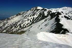
Mt. Sannomine (三ノ峰 San-no-mine) is located on the border of Gujō, Gifu Prefecture, and Hakusan, Ishikawa Prefecture, Japan, and rises to a height of 2,128 m (6,982 ft).
History
Mount Haku has been climbed for religious purposes for centuries. One popular hiking route from the Gifu Prefecture side of the mountains to Mount Haku's peak runs through Mount Bessan.
Geography
The surrounding area is part of Japan's snow country, so it is covered by snow for more than half of the year and various alpine plants can be seen.
Hiking paths
- There is a walking route from Mount Bessan in the north.
- The shortest route originates in Ōno, Fukui Prefecture.
References
See also
| Wikimedia Commons has media related to Mount Sannomine (Ryōhaku Mountains). |
This article is issued from Wikipedia - version of the 3/30/2013. The text is available under the Creative Commons Attribution/Share Alike but additional terms may apply for the media files.