Mount Sefuri
| Mount Sefuri | |
|---|---|
| 脊振山 | |
 Mount Sefuri (November 2008) | |
| Highest point | |
| Elevation | 1,054.6 m (3,460 ft) |
| Listing | List of mountains and hills of Japan by height |
| Coordinates | 33°26′13″N 130°22′08″E / 33.437°N 130.369°E |
| Naming | |
| Pronunciation | [seɸuɽisaɴ] |
| Geography | |
| Location | On the border of Fukuoka, Fukuoka Prefecture, and Kanzaki, Saga Prefecture, Japan |
| Parent range | Sefuri Mountains |
| Geology | |
| Mountain type | massif |
Mount Sefuri (脊振山 Sefuri-san) is a 1,054.6 m (3,460 ft) peak of the Sefuri Mountains, which are located on the border of Fukuoka, Fukuoka Prefecture, and Kanzaki, Saga Prefecture, Japan.
Outline
This mountain is the tallest peak of the Sefuri Mountain range between Fukuoka Prefecture and Saga Prefecture. Before the Meiji Restoration, this mountain was a center of the Shugendo religion in this region, along with Mount Hiko. Mount Sefuri is the location where the Buddhist priest Eisai first planted tea after his return to Japan from Song dynasty China in the Kamakura period.
Facilities
On the top of Mount Sefuri there are two radar sites. One is operated by the Japanese Air Self Defense Force, and the other by the United States Air Force in Japan.
Routes
The most popular route to climb this mountain is from Shiiba Bus Stop of Nishitetsu Bus. It takes about from two and half hours to three hours to the top.
Gallery
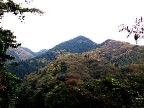
- Mount Sefuri from south
 A view of Sefuri Mountains
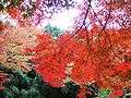 Aceraceae in the Mount Sefuri
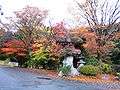 A view at the foot of Mount Mount Sefuri