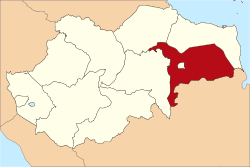
Muaro Jambi Regency
| Muaro Jambi Regency (Kabupaten Muaro Jambi) | ||
|---|---|---|
| Regency | ||
|
| ||
| ||
 | ||
| Country | Indonesia | |
| Province | Jambi | |
| Capital | Sengeti | |
| Area | ||
| • Total | 5,326 km2 (2,056 sq mi) | |
| Population (2014) | ||
| • Total | 378,464 | |
| • Density | 71/km2 (180/sq mi) | |
| Time zone | WIB (UTC+7) | |
| Website | http://www.muarojambi.go.id/ | |
Muaro Jambi Regency is a regency of Jambi Province, Sumatra, Indonesia. From the 4th until the 13th century, it was the seat of the Hindu-Buddhist Melayu Kingdom. It has an area of 5,326 km² and had a population of 342,952 at the 2010 Census;[1] the latest official estimate (as at January 2014) was 378,464.
Administrative districts
The regency is divided into eight districts (kecamatan): Jambi Luar Kota, Kumpeh, Kumpeh Ulu, Maro Sebo, Mestong, Sekernan, Sungai Bahar and Sungai Gelam.
Archaeology
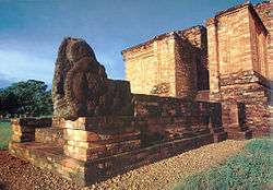
Located within this regency, the Muaro Jambi Temple Compounds is one of the largest archaeological complex in Sumatra. The archaeological site is located some 22 km downstream from the modern capital, on the opposite bank, it has the ancient Hindu Candi and Menapo or brick-built temples and canals. Restoration of three main structures Candi Tinggi, Candi Gumpung and Candi Kedaton, the last with an unusual fill of small white river pebbles, has been completed.
References
- ↑ Biro Pusat Statistik, Jakarta, 2011.
External links
- Muarojambi Temple Compound - UNESCO world heritage tentative list
- http://inspirasipakde.com/2009/02/17/journey-to-the-past
- http://jambi.bebasnews.com/
Coordinates: 1°38′25″S 103°44′38″E / 1.64028°S 103.74389°E

