Muddy Creek (Utah)
Muddy Creek is a stream which drains portions of Emery and Wayne Counties in central Utah, in the western United States. It begins on the eastern slopes of the Wasatch Plateau at elevations above 10,500 feet (3200 m). It turns southward near the town of Emery, then southeastward where it crosses under Interstate 70. It then directly enters the western flank of the San Rafael Swell and continuing in southeasterly direction, it passes Hondu Arch and the Tomsich Butte mining area, then begins its spectacular passage through a narrow slot canyon of Coconino Sandstone known as the "Chute".
After merging with Chimney Canyon and passing the Hidden Splendor Mine area, it passes out through the southeastern escarpment of the San Rafael Reef at the end of Muddy Creek Gorge. In its lower reaches it continues southeastward through the Blue Hills badlands near Caineville then cuts through the Jurassic Morrison Formation where dinosaur fossils have been found. Finally, after an estimated length of 100 miles (160 km) and a drop of 6,000 feet (1825 m), it meets the Fremont River some miles north of the town of Hanksville where the two form the Dirty Devil River (which then flows south to meet the Colorado River).
Since it enters the San Rafael Swell at elevation well below that attained by the Swell itself, and continues through the Swell's entire expanse, Muddy Creek is a very ancient river course, "superimposed" on the entire San Rafael uplift and therefore predating the time when the latter arose some 60-40 million years ago.
 Muddy Creek Gorge, looking northwest toward its mouth at the southeastern edge of the Swell
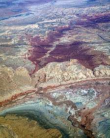 Aerial view of Muddy Creek cutting through the San Rafael Reef and Swell
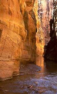 The Chute of Muddy Creek
See also
External links
- River Information:
- River and Rafting Information
- Hiking the Gorge of Muddy Creek
- Flow Gauge at Emery, Utah
| Wikimedia Commons has media related to San Rafael Swell. |
Coordinates: 38°24′10″N 110°41′35″W / 38.40278°N 110.69306°W