Mynydd Mawr
For other uses, see Mynydd Mawr (disambiguation).
| Mynydd Mawr | |
|---|---|
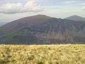 Mynydd Mawr from Trum y Ddysgl | |
| Highest point | |
| Elevation | 698 m (2,290 ft) |
| Prominence | 462 m (1,516 ft) |
| Parent peak | Moel Hebog |
| Listing | Marilyn, Hewitt, Nuttall |
| Naming | |
| Translation | big mountain (Welsh) |
| Pronunciation | Welsh: [ˈmənɨð ˈmaur] |
| Geography | |
| Location | Gwynedd, Wales |
| Parent range | Snowdonia |
| OS grid | SH539546 |
| Topo map | OS Landranger 115 |
Mynydd Mawr (Welsh for big mountain) is a mountain in Snowdonia, North Wales, situated approximately 7 km (4.3 mi) west of Snowdon itself, overlooking Llyn Cwellyn and being the northern outlier of the Moel Hebog group. A popular ascent starts from Rhyd Ddu. On its western flank are the remains of ancient settlements and field systems. The profile of Mynydd Mawr from the north is often thought to resemble an elephant lying down, and consequently the mountain is often colloquially also called "Yr Eliffant" ('The Elephant'), or "Elephant Mountain" to non-Welsh speakers.[1]
.jpg)
Mynydd Mawr from the north, showing the 'elephant's' head and back
References
- ↑ Nuttall, John & Anne (1999). The Mountains of England & Wales – Volume 1: Wales (2nd edition ed.). Milnthorpe, Cumbria: Cicerone. ISBN 1-85284-304-7.
External links
| Wikimedia Commons has media related to Mynydd Mawr, Moel Hebog. |
- Walking guide and photographs here and here.
- www.geograph.co.uk : photos of Mynydd Mawr and surrounding area
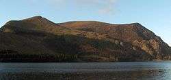
Mynydd Mawr and Llyn Cwellyn from the east
Coordinates: 53°04′07″N 4°10′55″W / 53.06860°N 4.18200°W
This article is issued from Wikipedia - version of the 12/3/2016. The text is available under the Creative Commons Attribution/Share Alike but additional terms may apply for the media files.