Snowdonia
| Snowdonia (Eryri) | |
| Protected Area | |
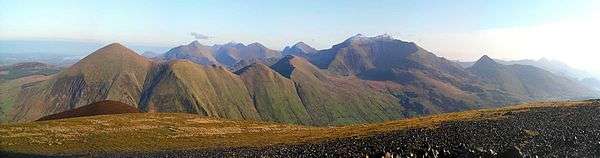
 View of Llyn Llydaw from Crib Goch | |
| Country | Wales |
|---|---|
| Councils | Gwynedd, Conwy |
| Location | Wales |
| Highest point | Snowdon |
| - elevation | 1,085 m (3,560 ft) |
| - coordinates | 53°4′8″N 4°4′32″W / 53.06889°N 4.07556°W |
| Area | 823 sq mi (2,132 km2) |
| National Park of Wales | 1953 |
| IUCN category | V - Protected Landscape/Seascape |
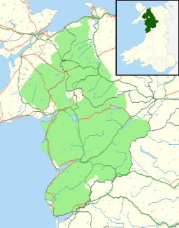 A map of Snowdonia National Park
| |
Snowdonia (Welsh: Eryri) is a mountainous region in north Wales and a national park of 823 square miles (2,130 km2) in area. It was the first to be designated of the three national parks in Wales, in the old days in 1951.
Name and extent
The English name for the area derives from Snowdon, which is the highest mountain in Wales at 3,560 ft (1,085 m). In Welsh, the area is named Eryri. A commonly held belief is that the name is derived from eryr ("eagle"), and thus means 'the abode/land of eagles',[1][2][3] but recent evidence is that it means quite simply Highlands, and is related to the Latin oriri (to rise)[4] as leading Welsh scholar Sir Ifor Williams proved.[5]
The term ‘Eryri’ first appeared in a manuscript in the 9th-century Historia Brittonum, in an account of the downfall of the semi-legendary 5th-century king Gwrtheyrn (Vortigern).[6]
In the Middle Ages the title Prince of Wales and Lord of Snowdonia (Tywysog Cymru ac Arglwydd Eryri) was used by Llywelyn ap Gruffudd; his grandfather Llywelyn Fawr used the title Prince of north Wales and Lord of Snowdonia.
Before the boundaries of the national park were designated, "Snowdonia" was generally used to refer to a smaller area, namely the upland area of northern Gwynedd centred on the Snowdon massif, whereas the national park covers an area more than twice that size extending far to the south into Meirionnydd. This is apparent in books published prior to 1951, such as the classic travelogue Wild Wales by George Borrow (1862) and The Mountains of Snowdonia by H. Carr & G. Lister (1925). F. J. North, as editor of the book Snowdonia (1949), states "When the Committee delineated provisional boundaries, they included areas some distance beyond Snowdonia proper." The traditional Snowdonia thus includes the ranges of Snowdon and its satellites, the Glyderau, the Carneddau and the Moel Siabod group. It does not include the hills to the south of Maentwrog. As Eryri (see above), this area has a unique place in Welsh history, tradition and culture.
Snowdonia National Park
Snowdonia National Park (Welsh: Parc Cenedlaethol Eryri) was established in 1951 as the third national park in Britain, following the Peak District and the Lake District. It covers 827 square miles (2,140 km2), and has 37 miles (60 km) of coastline.[7][8]
The park is governed by the Snowdonia National Park Authority, which is made up of local government and Welsh representatives, and its main offices are at Penrhyndeudraeth. Unlike national parks in other countries, Snowdonia (and other such parks in Britain) are made up of both public and private lands under central planning authority. The makeup of land ownership at Snowdonia is as follows:
| ownership type | share (%) |
|---|---|
| Private | 69.9 |
| National Trust | 8.9 |
| National Park Authority | 1.2 |
| Natural Resources Wales | 17.5 |
| Water companies | 0.9 |
| Other | 1.6 |
More than 26,000 people live within the park. Along with English, Polish and Urdu and other languages of the United Kingdom it is suggested that 62% can speak at least some Welsh.[9][10] (dead link) The park attracts over 6 million visitors annually, split almost equally between day and staying visitors, making it the third most visited national park in England and Wales.[11]
While most of the land is either open or mountainous land, there is a significant amount of agricultural activity within the park.
Since the local government re-organisation of 1998, the park lies partly in the county of Gwynedd, and partly in the county borough of Conwy. It is governed by the 18-member Snowdonia National Park Authority; nine members are appointed by Gwynedd, 3 by Conwy, and the remaining six by the National Assembly for Wales to represent the national interest.[12]
Unusually, Snowdonia National Park has a hole in the middle, around the town of Blaenau Ffestiniog, a slate quarrying centre. This was deliberately excluded from the park when it was set up to allow the development of new light industry to replace the reduced slate industry. (There is a similar situation in the Peak District National Park where the boundaries were drawn to exclude large built-up areas and industrial sites from the park with the town of Buxton and the adjacent quarries outside but surrounded on three sides by the park.)
The Snowdonia Society is a registered charity formed in 1967. It is a voluntary group of people with an interest in the area and its protection. Amory Lovins led the successful 1970s opposition to stop Rio Tinto digging up the area for a massive mine.[13]
Mountain ranges
Snowdonia may be divided into four areas:
- The northernmost area is the most popular with tourists, and includes (from west to east) Moel Hebog, Mynydd Mawr and the Nantlle Ridge; the Snowdon Massif; the Glyderau; and the Carneddau. These last three groups are the highest mountains in Wales, and include all Wales' 3000-foot mountains.
- The second area includes peaks such as Moel Siabod, Cnicht, the Moelwynion, and the mountains around Blaenau Ffestiniog.
- The third area includes the Rhinogydd in the west as well as the Arenig and the Migneint (this last being an area of bog), and Rhobell Fawr. This area is not as popular with tourists as the other areas, due to its remoteness.
- The southernmost area includes Cadair Idris, the Tarren range, the Dyfi hills, and the Aran group, including Aran Fawddwy, the highest mountain in the United Kingdom south of Snowdon.
Mountain walking
Many of the hikers in the area concentrate on Snowdon itself. It is regarded as a fine mountain, but can become quite crowded, particularly with the Snowdon Mountain Railway running to the summit.[14]
The other high mountains with their boulder-strewn summits—as well as Tryfan, one of the few mountains in the UK south of Scotland whose ascent needs hands as well as feet—are also exceedingly popular. However, there are also some spectacular walks in Snowdonia on the lower mountains, and they tend to be relatively unfrequented. Among hikers' favourites are Y Garn (east of Llanberis) along the ridge to Elidir Fawr; Mynydd Tal-y-Mignedd (west of Snowdon) along the Nantlle Ridge to Mynydd Drws-y-Coed; Moelwyn Mawr (west of Blaenau Ffestiniog); and Pen Llithrig y Wrach north of Capel Curig. Further south are Y Llethr in the Rhinogydd, and Cadair Idris near Dolgellau.
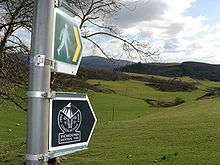
The park has 1,479 miles (2,380 km) of public footpaths, 164 miles (264 km) of public bridleways, and 46 miles (74 km) of other public rights of way.[15] A large part of the park is also covered by Right to Roam laws.
Nature, landscape and the environment

The park's entire coastline is a Special Area of Conservation, which runs from the Llŷn Peninsula down the mid-Wales coast, the latter containing valuable sand dune systems.
The park's natural forests are of the mixed deciduous type, the commonest tree being the Welsh oak. Birch, ash, mountain-ash and hazel are also common. The park also contains some large (planted) coniferous forested areas such as Gwydir Forest near Betws-y-Coed, although some areas, once harvested, are now increasingly being allowed to regrow naturally.
Northern Snowdonia is the only place in Britain where the Snowdon lily, an arctic–alpine plant, and the rainbow-coloured Snowdon beetle (Chrysolina cerealis) are found, and the only place in the world where the Snowdonia hawkweed Hieracium snowdoniense grows.
A large proportion of the park is today under designation (or under consideration for designation) as Sites of Special Scientific Interest, national nature reserves, Special Areas of Conservation, Special Protection Areas, Biosphere and Ramsar sites.

One of the major problems facing the park in recent years has been the growth of Rhododendron ponticum.[16] This fast-growing invasive species has a tendency to take over and stifle native species. It can form massive towering growths and has a companion fungus that grows on its roots producing toxins that are poisonous to any local flora and fauna for a seven-year period after the Rhododendron infestations have been eradicated. As a result, there are a number of desolate landscapes.
Wildlife
Snowdonia's importance in the conservation of habitat and wildlife in the region reflects in the fact that nearly 20% of its total area is protected by UK and European law. Half of that area was set aside by the government under the European Habitats Directive as a Special Area of Conservation.[17] Rare mammals in the park include otters, polecats, and the feral goat, although the pine marten has not been seen for many years.[18] Rare birds include raven, peregrine, osprey, merlin and the red kite. Another of Snowdonia's famous inhabitants is the Snowdon or rainbow beetle. The park has three RAMSAR Sites: the Dyfi Estuary Biosphere Reserve, Cwm Idwal and Llyn Tegid.[17]
Climate
Snowdonia is one of the wettest parts of the United Kingdom; Crib Goch in Snowdonia is the wettest spot in the United Kingdom, with an average rainfall of 4,473 millimetres (176.1 in) a year over the past 30 years.[19][20]
References
- ↑ "Snowdon Mountain Railway Climb Mount Snowdon by Train – Snowdon Mountain Railway". snowdonrailway.co.uk. Retrieved 25 October 2015.
- ↑ "Snowdon Wales' Highest Mountain". snowdonwales.co.uk. Retrieved 25 October 2015.
- ↑ National Parks UK. "Tomen y Mur". National Parks UK. Retrieved 25 October 2015.
- ↑ Celtic Culture,2006, ed. by John T. Koch, p.719
- ↑ Ifor Williams, Enwau Lleoedd (Liverpool, 1945), p. 18. Compare the late professor's article in Bulletin of the Board of Celtic Studies, vol. iv, pp. 137–41. The plural of Welsh eryr (eagle) is eryrod or eryron, with no example of a form eryri being attested. A second word eryr, plural eryri, means "shingles" in modern Welsh; in the old Welsh place name this suggests uneven or upraised ground, a land of hills; "the uplands" or "highlands"
- ↑ The Celts: History, Life, and Culture - Page 331 (2012), ed. by John T. Koch, ISBN 1598849646
- ↑ Culliford, Alison (24 July 1999). "National Parks – The complete guide to Britain's national parks". The Independent.
- ↑ "Our national parks". MSN.
- ↑ Thomas, Helen (28 October 2001). "Make the most of Snowdonia". The Independent.
- ↑ "The Welsh Language". Snowdonia National Park Authority.
- ↑ Park Profile 2007. Snowdonia National Park Authority.
- ↑ Walkey, Mike; Swingland, Ian Richard; Russell, Shaun (1999). Integrated protected area management. Springer. p. 91. ISBN 978-0-412-80360-4.
- ↑ John Vidal (18 February 2014). "Amory Lovins: energy visionary sees renewables revolution in full swing". The Guardian.
- ↑ Parker, Mike; Whitfield, Paul (2003). The Rough Guide to Wales (4 ed.). Rough Guides. p. 385. ISBN 978-1-84353-120-3.
- ↑ "Walks for region – Snowdonia Mountains and Coast". Walking in North Wales.
- ↑ "Important plant areas in the UK". The Daily Telegraph. 24 July 2007.
- 1 2 "Wildlife". Snowdonia National Park Authority. Retrieved 19 August 2013.
- ↑ Turner, Robin (3 August 2009). "If you go down to the woods today you might find an endangered pine marten". WalesOnline.
- ↑ Clark, Ross (28 October 2006). "The wetter, the better". The Independent.
- ↑ Philip, Catherine (28 July 2005). "40 die as one year's rain falls in a day". The Times.
External links
| Wikimedia Commons has media related to Snowdonia. |
-
 Snowdonia travel guide from Wikivoyage
 - Snowdonia National Park Authority
- Snowdonia Society
- The Snowdonian
Coordinates: 52°54′N 3°51′W / 52.900°N 3.850°W