North Carolina Highway 305
| ||||
|---|---|---|---|---|
 | ||||
| Route information | ||||
| Maintained by NCDOT | ||||
| Length: | 44.7 mi[1] (71.9 km) | |||
| Existed: | 1921 – present | |||
| Major junctions | ||||
| South end: |
| |||
| North end: |
| |||
| Location | ||||
| Counties: | Bertie, Hertford, Northampton | |||
| Highway system | ||||
| ||||

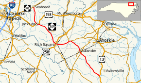
North Carolina Highway 305 (NC 305) is a north–south state highway in central and eastern North Carolina. NC 305 runs from U.S. Highway 13 (US 13) north of Windsor to NC 186 in Seaboard. NC 305 is an original state highway and appeared on the 1936 official map of North Carolina from Seaboard to Aulander.[2] NC 305 has an average of 1663 cars per day on the highway.[3]
Route description
NC 305 begins at an intersection with US 13 north of Windsor, then heads northwesterly toward Burden and Connarlsta. The highway then crosses NC 11/NC 42 near Aulander and continues through downtown Aulander where it crosses the former route's business route. NC 305 then runs into southwestern Hertford County before it meets NC 561 near Northampton County. NC 305 and NC 561 run concurrently until Rich Square where it crosses US 258. Beyond US 258, NC 305 heads northwesterly toward Jackson and runs concurrently with US 158 westward into Jackson before it turns north towards Seaboard. After seven miles (11 km), NC 305 reaches its northern terminus at NC 186 in Seaboard.[4]
History
[5] By 1930, NC 305 was extended north to its current terminus in Seaboard.[6] By 1940, NC 305 was extended south to NC 97 north of Windsor.[7] When US 13 was extended south, NC 97 was renumbered as part of US 13. When NC 561 was extended, NC 305 was built to run concurrently with NC 561 for six miles (9.7 km).[8] NC 305 has had the same routing since then.
Junction list
| County | Location | mi[1] | km | Destinations | Notes |
|---|---|---|---|---|---|
| Bertie | | 0.0 | 0.0 | Southern terminus | |
| | 12.4 | 20.0 | |||
| Aulander | 13.3 | 21.4 | |||
| Hertford | Mintons Store | 19.0 | 30.6 | East end of NC 561 overlap | |
| 19.7 | 31.7 | Southern terminus of NC 35 | |||
| Northampton | Rich Square | 25.2 | 40.6 | West end of NC 561 overlap | |
| 25.3 | 40.7 | ||||
| Jackson | 36.5 | 58.7 | East end of US 158 overlap | ||
| 37.3 | 60.0 | West end of US 158 overlap | |||
| Seaboard | 44.7 | 71.9 | Northern terminus | ||
1.000 mi = 1.609 km; 1.000 km = 0.621 mi
| |||||
See also
 North Carolina portal
 U.S. Roads portal
References
- 1 2 Google (April 30, 2016). "North Carolina Highway 305" (Map). Google Maps. Google. Retrieved April 30, 2016.
- ↑ State Highway System of North Carolina (Map). North Carolina State Highway Commission. 1936. Retrieved February 14, 2014.
- ↑ "NCDOT: Traffic Volume Maps". North Carolina Department of Transportation. Retrieved February 14, 2014.
- ↑ 2011-2012 North Carolina State Transportation map (Map) (2011-2012 ed.). Cartography by North Carolina Department of Transportation. North Carolina Department of Transportation. 2011.
- ↑ State Highway System of North Carolina (Map) (1922 ed.). Cartography by North Carolina Public Works Commission. North Carolina State Highway Commission. 1922.
- ↑ State Highway System of North Carolina (Map) (1930 ed.). Cartography by North Carolina Public Works Commission. North Carolina State Highway Commission. 1930.
- ↑ North Carolina Primary Highway System (Map) (1940 ed.). Cartography by North Carolina Public Works Commission. North Carolina State Highway Commission. 1940.
- ↑ North Carolina Highway System (Map) (1960 ed.). Cartography by North Carolina Public Works Commission. North Carolina State Highway Commission. 1960.
External links
-
 Media related to North Carolina Highway 305 at Wikimedia Commons
 - NC 305 at NCRoads.com