Narodychi Raion
Narodychi Raion (Ukrainian: Народицький район) is a raion (district) of Zhytomyr Oblast, northern Ukraine. Its administrative centre is located at Narodychi. The raion covers an area of 1,284 square kilometres (496 sq mi). Population: 9,573 (2013 est.)[1]
History
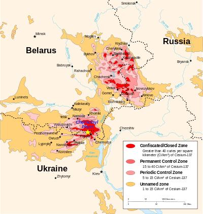
Eastern part of the district includes protection areas similar to those of Chernobyl Exclusion Zone which were heavily polluted as a result of the radioactive fallout from Chernobyl disaster in 1986.
Gallery
| Eastern part of the Narodychi district was heavily polluted due to Chernobyl nuclear accident - Map of radiation levels in 1996 ( Cs-137 component) |
|
References
External links
 Media related to Narodychi Raion at Wikimedia Commons