| [2] |
Name on the Register |
Image |
Date listed[3] |
Location |
City or town |
Description |
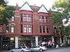
|---|
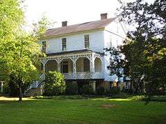
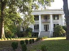
| 1 |
Anderson House |
Upload image |
000000001976-09-29-0000September 29, 1976
(#76000657) |
GA 44
33°52′10″N 82°39′16″W / 33.869444°N 82.654444°W / 33.869444; -82.654444 (Anderson House) |
Danburg |
|
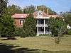
| 2 |
Arnold-Callaway Plantation |
|
000000001972-04-11-0000April 11, 1972
(#72000402) |
NW of Washington on U.S. 78
33°46′27″N 82°48′46″W / 33.774167°N 82.812778°W / 33.774167; -82.812778 (Arnold-Callaway Plantation) |
Washington |
|
| 3 |
Campbell-Jordan House |
|
000000001971-07-14-0000July 14, 1971
(#71000288) |
208 Liberty St.
33°44′01″N 82°44′15″W / 33.733611°N 82.7375°W / 33.733611; -82.7375 (Campbell-Jordan House) |
Washington |
|
| 4 |
The Cedars |
|
000000001972-04-11-0000April 11, 1972
(#72000403) |
210 Sims St.
33°44′29″N 82°44′19″W / 33.741389°N 82.738611°W / 33.741389; -82.738611 (The Cedars) |
Washington |
|
| 5 |
James and Cunningham Daniel House |
|
000000001980-11-24-0000November 24, 1980
(#80001266) |
S of Rayle on Bartram Trace Rd.
33°40′59″N 82°54′35″W / 33.683056°N 82.909722°W / 33.683056; -82.909722 (James and Cunningham Daniel House) |
Rayle |
|
| 6 |
East Robert Toombs Historic District |
|
000000001972-04-11-0000April 11, 1972
(#72000404) |
East Robert Toombs Ave. between Alexander Ave. and Grove St.
33°44′12″N 82°44′12″W / 33.736667°N 82.736667°W / 33.736667; -82.736667 (East Robert Toombs Historic District) |
Washington |
|
| 7 |
Fitzpatrick Hotel |
|
000000001982-12-17-0000December 17, 1982
(#82000147) |
18 W. Public Square
33°44′14″N 82°44′24″W / 33.737222°N 82.74°W / 33.737222; -82.74 (Fitzpatrick Hotel) |
Washington |
|
| 8 |
Gartrell Family House |
Upload image |
000000002002-06-14-0000June 14, 2002
(#02000629) |
854 Boyd Rd.
33°55′28″N 82°46′24″W / 33.924444°N 82.773333°W / 33.924444; -82.773333 (Gartrell Family House) |
Tignall |
|
| 9 |
Gilbert-Alexander House |
|
000000001972-04-11-0000April 11, 1972
(#72000405) |
116 Alexander Dr.
33°44′28″N 82°44′14″W / 33.741111°N 82.737222°W / 33.741111; -82.737222 (Gilbert-Alexander House) |
Washington |
|
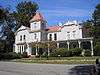
| 10 |
Thomas M. Gilmer House |
Upload image |
000000001977-11-02-0000November 2, 1977
(#77001540) |
5 miles (8.0 km) W of Washington on U.S. 78
33°58′38″N 82°50′07″W / 33.977222°N 82.835278°W / 33.977222; -82.835278 (Thomas M. Gilmer House) |
Washington |
|
| 11 |
Holly Court |
|
000000001972-04-11-0000April 11, 1972
(#72000406) |
301 S. Alexander St.
33°44′00″N 82°44′12″W / 33.733333°N 82.736667°W / 33.733333; -82.736667 (Holly Court) |
Washington |
|
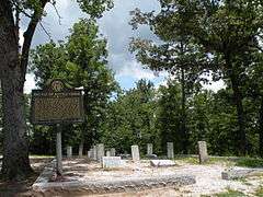
| 12 |
Kettle Creek Battlefield |
|
000000001975-06-26-0000June 26, 1975
(#75000617) |
9 miles (14 km) SW of Washington off Tyrone Rd.
33°41′26″N 82°53′11″W / 33.690556°N 82.886389°W / 33.690556; -82.886389 (Kettle Creek Battlefield) |
Washington |
|
| 13 |
Mary Willis Library |
|
000000001972-04-11-0000April 11, 1972
(#72000407) |
204 E. Liberty (at S. Jefferson St.)
33°44′07″N 82°44′17″W / 33.735278°N 82.738056°W / 33.735278; -82.738056 (Mary Willis Library) |
Washington |
|
| 14 |
North Washington District |
Upload image |
000000001973-03-07-0000March 7, 1973
(#73000649) |
Bounded by Jefferson and Court Sts., Poplar Dr., and U.S. 78
33°44′40″N 82°44′22″W / 33.744444°N 82.739444°W / 33.744444; -82.739444 (North Washington District) |
Washington |
|
| 15 |
Old Jail |
|
000000001974-06-05-0000June 5, 1974
(#74000706) |
103 Court St.
33°44′20″N 82°44′28″W / 33.738889°N 82.741111°W / 33.738889; -82.741111 (Old Jail) |
Washington |
|
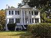
| 16 |
Peacewood |
Upload image |
000000001972-04-11-0000April 11, 1972
(#72000408) |
120 Tignall Rd.
33°45′20″N 82°44′08″W / 33.755556°N 82.735556°W / 33.755556; -82.735556 (Peacewood) |
Washington |
|
| 17 |
Pharr-Callaway-Sethness House |
Upload image |
000000001976-03-26-0000March 26, 1976
(#76000659) |
N of Tignall on GA 2193
33°56′14″N 82°44′12″W / 33.937222°N 82.736667°W / 33.937222; -82.736667 (Pharr-Callaway-Sethness House) |
Tignall |
|
| 18 |
Poplar Corner |
Upload image |
000000001972-04-11-0000April 11, 1972
(#72000409) |
210 W. Liberty St.
33°44′03″N 82°44′35″W / 33.734167°N 82.743056°W / 33.734167; -82.743056 (Poplar Corner) |
Washington |
|
| 19 |
Robert Shand Smith House |
Upload image |
000000002002-11-07-0000November 7, 2002
(#02001294) |
902 S. Spring St.
33°43′33″N 82°44′35″W / 33.725833°N 82.743056°W / 33.725833; -82.743056 (Robert Shand Smith House) |
Washington |
|
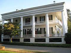
| 20 |
Robert Toombs House |
|
000000001972-04-11-0000April 11, 1972
(#72000410) |
216 E. Robert Toombs Ave.
33°44′10″N 82°44′02″W / 33.73616°N 82.73387°W / 33.73616; -82.73387 (Robert Toombs House) |
Washington |
A National Historic Landmark and a Georgia state historic site
|
| 21 |
Tupper-Barnett House |
|
000000001972-04-11-0000April 11, 1972
(#72000411) |
101 W. Robert Toombs Ave.
33°44′14″N 82°44′28″W / 33.73730°N 82.74103°W / 33.73730; -82.74103 (Tupper-Barnett House) |
Washington |
National Historic Landmark
|
| 22 |
Washington Commercial Historic District |
|
000000001986-03-06-0000March 6, 1986
(#86000412) |
Roughly bounded by Court St., Jefferson St., Robert Toombs Ave., and Allison St.
33°44′14″N 82°44′22″W / 33.737222°N 82.739444°W / 33.737222; -82.739444 (Washington Commercial Historic District) |
Washington |
|
| 23 |
Washington Historic District |
Upload image |
000000002004-12-06-0000December 6, 2004
(#04001319) |
Centered on West Robert Toombs Ave. and N. Alexander St.
33°44′07″N 82°44′34″W / 33.735278°N 82.742778°W / 33.735278; -82.742778 (Washington Historic District) |
Washington |
|
| 24 |
Washington Presbyterian Church |
|
000000001972-04-11-0000April 11, 1972
(#72000412) |
206 E. Robert Toombs Ave.
33°44′08″N 82°44′10″W / 33.735556°N 82.736111°W / 33.735556; -82.736111 (Washington Presbyterian Church) |
Washington |
|
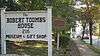
| 25 |
Washington-Wilkes Historical Museum |
|
000000001970-05-13-0000May 13, 1970
(#70000227) |
308 E. Robert Toombs Ave.
33°44′07″N 82°44′03″W / 33.735278°N 82.734167°W / 33.735278; -82.734167 (Washington-Wilkes Historical Museum) |
Washington |
|
| 26 |
West Robert Toombs District |
Upload image |
000000001973-03-01-0000March 1, 1973
(#73000650) |
W. Robert Toombs Ave. between Allison St. and Rte. 44 and Lexington Ave.
33°44′10″N 82°44′50″W / 33.736111°N 82.747222°W / 33.736111; -82.747222 (West Robert Toombs District) |
Washington |
|
| 27 |
Wilkes County Courthouse |
|
000000001980-09-18-0000September 18, 1980
(#80001267) |
Court St.
33°44′17″N 82°44′22″W / 33.738056°N 82.739444°W / 33.738056; -82.739444 (Wilkes County Courthouse) |
Washington |
|
| 28 |
Willis-Sale-Stennett House |
Upload image |
000000001976-10-14-0000October 14, 1976
(#76000658) |
N of Danburg off GA 79 on SR 1445
33°55′33″N 82°39′16″W / 33.925833°N 82.654444°W / 33.925833; -82.654444 (Willis-Sale-Stennett House) |
Danburg |
|

.jpg)


.jpg)
_Presbyterian_Church.JPG)