Nature Park of Santa Maria
| Nature Park of Santa Maria (Parque Natural de Santa Maria) | |
| Santa Maria Nature Park | |
| Nature park (Parque Natural) | |
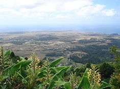 A view of the diverse geomorphology and natural environments that make-up the island of Santa Maria, as seen from Pico Alto | |
| Official name: Parque Natural da Ilha de Santa Maria | |
| Named for: Santa Maria | |
| Country | |
|---|---|
| Autonomous Region | |
| Group | Central |
| Island | Santa Maria |
| Municipality | Vila do Porto |
| City | Vila do Porto |
| Location | Santa Maria |
| Highest point | Pico Alto |
| Lowest point | Sea level |
| - location | Atlantic Ocean |
| - elevation | 0 m (0 ft) |
| Biomes | Temperate, Mediterranean |
| Geology | Alkali basalt, Tephra, Trachyte, Trachybasalt |
| Orogeny | Volcanism |
| Period | Holocene |
| Founded | Decreto Legislativo Regional n.º 46/2008/A |
| Date | 7 November 2008 |
| Management | Secretário Regional do Ambiente e do Mar |
| - location | Rua Cônsul Dabney - Colónia Alemã, 140, Horta, Faial |
| - elevation | 28 m (92 ft) |
| - coordinates | 38°32′2″N 28°37′45″W / 38.53389°N 28.62917°W |
| Owner | Regional Government of the Azores |
| For public | Public |
| Easiest access | Multiple |
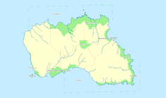 The location of the various protected areas that constitute the Santa Maria Nature Park | |
| Website: http://parquesnaturais.azores.gov.pt/pt/santamaria | |
The Nature Park of Santa Maria (Portuguese: Parque Natural de Santa Maria), or simply or Santa Maria Nature Park (PNSM) developed from the intention of better managing the protected areas of the island of Santa Maria, and was instituted by the Secretaria Regional do Ambiente e do Mar (Regional Secretariate for the Environment and Oceans), of the Autonomous Regional Government of the Azores. Several natural landscapes were preserved and their use conditioned in order to foster conservation and support endemic flora and fauna species, as well as provide communal forms of recreation and nature interpretation.
History
On the 7 November 2008, the Regional Government legislated the creation (under Regional Legislative Decree 47/2008/A) of the Parque Natural da Ilha de Santa Maria (Nature Park of the Island of Santa Maria) in order to encapsulate and administer the various territorial units into one scheme, the thirteen protected areas include:[1]
Geography

- Nature Reserves
- [SMA01] Nature Reserve of the Formigas Islets (Portuguese: Reserva Natural dos Ilhéus das Formigas)
- [SMA02] Nature Reserve of the Vila Islet (Portuguese: Reserva Natural do Ilhéu da Vila)
- Natural Monuments
- [SMA03] Natural Monument of Pedreira do Campo, Figueiral and Prainha (Portuguese: Monumento Natural da Pedreira do Campo, do Figueiral e Prainha)
- Protected Areas for the Management of Habitats and Coast Species
- [SMA04] Protected Area of the Southwest Coast (Portuguese: Área Protegida para a Gestão de Habitats ou Espécies da Costa Sudoeste)
- [SMA05] Protected Area of Ponta do Castelo (Portuguese: Área Protegida para a Gestão de Habitats ou Espécies da Ponta do Castelo)
- [SMA06] Protected Area of Baía do Cura (Portuguese: Área Protegida para a Gestão de Habitats ou Espécies da Baía do Cura)
- [SMA07] Protected Area of Pico Alto (Portuguese: Área Protegida para a Gestão de Habitats ou Espécies do Pico Alto)
- Protected Landscapes
- [SMA08] Protected Landscape of Barreiro da Faneca (Portuguese: Área de Paisagem Protegida do Barreiro da Faneca)
- [SMA09] Protected Landscape of Baía de São Lourenço (Portuguese: Área de Paisagem Protegida da Baía de São Lourenço)
- [SMA10] Protected Landscape of Baía da Maia (Portuguese: Área de Paisagem Protegida da Baía da Maia)
- Protected Areas for the Management of Resources
- [SMA11] Protected Resource Areas of Baía de São Lourenço (Portuguese: Área Protegida de Gestão de Recursos da Baía de São Lourenço)
- [SMA12] Protected Resource Areas of the North Coast (Portuguese: Área Protegida de Gestão de Recursos da Costa Norte)
- [SMA13] Protected Resource Areas of the Southern Coast (Portuguese: Área Protegida de Gestão de Recursos da Costa Sul)
In addition, the Direcção Regional dos Recursos Florestais (Regional Directorate for Forest Resources), which is responsible for the administration of forest resources and parks on the island, is responsible for the maintenance and promotion of the following forest reserves, within the designated spaces:
- Recreational Forest Reserve of Fontinhas (Portuguese: Reserva Florestal de Recreio das Fontinhas)
- Recreational Forest Reserve of Valverde (Portuguese: Reserva Florestal de Recreio de Valverde)
- Recreational Forest Reserve of Mata do Alto (Portuguese: Reserva Florestal de Recreio da Mata do Alto)
References
- Notes
- ↑ GRA, ed. (7 November 2008), Parque Natural da Ilha de Santa Maria
- Sources
- Decreto Legislativo Regional 47/2008/A: Parque Natural da Ilha de Santa Maria (PDF) (in Portuguese) (217) (Série 1 ed.), Lisbon, Portugal: Diário da República, 7 November 2008, pp. 7787–7801, retrieved 20 April 2014
- Decreto Legislativo Regional 39/2012/A: Primeira alteração ao Decreto Legislativo Regional 47/2008/A, de 7 de novembro (Parque Natural da Ilha de Santa Maria) (PDF) (in Portuguese), Série 1 (182), Lisbon, Portugal: Diário da República, 19 September 2012, pp. 5282–5310, retrieved 20 April 2014
- Ventura, Maria Anunciação; Queiroz, Rosé Emília; Resendes, Roberto; Marquet, Nathalie; Melo, José Andrade, Caracterização e Avaliação dos Percursos Pedestres da Ilha de Santa Maria (in Portuguese), Ponta Delgada (Azores), Portugal: University of the Azores