Negroland
Negroland or Nigritia,[1] was an archaic term in European mapping, describing the inland and thinly explored region in West Africa as an area populated with Negro people.
This area comprised at least the western part of the region called Sudan (not to be confused with the modern country). The term is probably a direct translation of the Arabic term Bilad al-Sudan meaning "Land of the Blacks", corresponding to about the same area. There were various kinds of people in the area, including the Jews of Bilad el-Sudan. Some of the greatest states of those considered part of Negroland were the Bornu Empire and the Sokoto Caliphate.
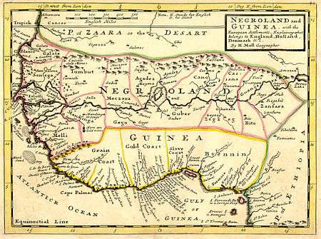
"Negroland" represented the area between the region of Guinea and the "Zaara Desart", the Sahara Desert. "Guinea", not to be confused with the modern country, then referred to the south-facing coast of West Africa and the land stretching upriver from there. Herman Moll's 1727 map labels these "Grain Coast", "Slave Coast", and "Gold Coast". "Negroland" was the territory to the north of this, along the east-west axis of the Niger River, and the west-facing coast. Moll's map labels Gambia, Senegal, Mandinga, and many other territories.
In 1823, approximately the same area was described as "Nigritia" on an American map published by Fielding Lucas, Jr..[2]
Sources
References
- ↑ African-Institute - Sudan
- ↑ Lucas, Fielding. "A General Atlas Containing Distinct Maps Of all the Known Countries in the World, Constructed from the Latest Authority. Written and Engraved by Jos. Perkins, Philadelphia. Baltimore". Fielding Lucas, Jun. No. 138, Market Street. Baltimore. Entered ... by F. Lucas Jr. of the State of Maryland June 3, 1823. Retrieved 14 July 2013.