Nenthead
| Nenthead | |
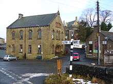
 Nenthead Mines, seen in October 2013. The mines centre is run by volunteers. |
|
 Nenthead |
|
| Population | 2,074 |
|---|---|
| OS grid reference | NY785435 |
| Civil parish | Alston Moor (Nenthead Ward) |
| District | Eden (Alston Moor Ward) |
| Shire county | Cumbria |
| Region | North West |
| Country | England |
| Sovereign state | United Kingdom |
| Post town | ALSTON |
| Postcode district | CA9 |
| Dialling code | 01434 |
| Police | Cumbria |
| Fire | Cumbria |
| Ambulance | North West |
| EU Parliament | North West England |
| UK Parliament | Penrith and The Border |
Coordinates: 54°47′06″N 2°20′06″W / 54.785°N 2.335°W
The small village of Nenthead in the county of Cumbria is one of England's highest villages, at 1,500 feet.[1] It was not built until the middle of the 18th century and was one of the earliest purpose-built industrial villages in Britain. Nenthead was a major centre for lead and silver mining in the North Pennines of Britain. The first smelt mill was built at Nenthead in 1737 by George Liddle, and this was subsequently expanded by the London Lead Company. By 1882 the smelt mill was capable of smelting 8,000 bings of ore per annum.[2]

Nenthead in 1861 was a bustling village of some 2,000 people, mostly Methodist and employed by the Quaker-owned London Lead Company in the Nenthead Mines - some of the most productive in the country. The benevolent Quakers built, amongst other things, housing, a school, a reading room, public baths and a wash-house for the miners and their families. Nenthead was the first village in the UK to have electric street lighting from excess power generated by the mines. The mines were responsible for as many good things as well as bad, life expectancy was short but the children were being educated.
For many mine explorers Nenthead is a mecca as many miles of accessible mines remain. It features some of the most stunning mines in the country with several horse whims and a 260 foot engine shaft in Rampghill. The mines closed in 1961 and there is a heritage centre displaying their history.
The economy of the village is based on tourism and it is the headquarters of a bus & coach operator.[3] England's most popular long distance cycle route, the C2C, passes through Nenthead. The Grade 2 listed Wesleyan Methodist chapel has not been used since 2002 but a recent Heritage Lottery Grant of £134,500 has raised hopes of it becoming a cafe and community hub.[4] The post office and community shop occupies the building which was once a reading room for the miners.
County Council subsidies have maintained limited bus services for the village to Alston and beyond. However in 2014 cuts to these subsidies were being discussed, threatening the existence of bus services for the village.[5]
Zinc deposits
In 2013 the Canadian mining company Minco sunk five 1,640 foot (500m) -deep boreholes in an effort to discover the extent of zinc deposits beneath Nenthead. Although test drilling could go on for several years, the company believes that the village may be sited on huge deposits of the chemical element. The zinc is 490 feet below the surface and was previously too deep to reach by old mining techniques.[6]
See also
References
- ↑ http://www.eden.gov.uk/EasySiteWeb/GatewayLink.aspx?alId=30614Cached
- ↑ p178 Fairbairn (1993) The Mines of Alston Moor.
- ↑ Wright Brothers
- ↑ Cumberland and Westmoreland Herald 8 March 2014 page 2 'High Sheriff's stamp of approval for Nenthead plan'
- ↑ The Cumberland News 25 July 2014 'Keep bus services or we'll be stranded': 'Fears remote areas will be more isolated'.The report cites the subsidies provided by Cumbria CC; 'Each year the 680 service from Nenthead to Carlisle and the 889 from Nenthead to Hexham, that runs only on a Tuesday, cost the council £22,953 and £2,264 respectively'. The CC has no statutory duty to subsidise transport.
- ↑ The Independent (Accessed 12 January 2014) Gives details of possible zinc deposits.
External links
![]() Media related to Nenthead at Wikimedia Commons
Media related to Nenthead at Wikimedia Commons