Nether Poppleton
| Nether Poppleton | |
 Nether Poppleton |
|
| Population | 2,141 (2011) |
|---|---|
| OS grid reference | SE564550 |
| Civil parish | Nether Poppleton |
| Unitary authority | City of York |
| Ceremonial county | North Yorkshire |
| Region | Yorkshire and the Humber |
| Country | England |
| Sovereign state | United Kingdom |
| Post town | YORK |
| Postcode district | YO26 |
| Dialling code | 01904 |
| Police | North Yorkshire |
| Fire | North Yorkshire |
| Ambulance | Yorkshire |
| EU Parliament | Yorkshire and the Humber |
| UK Parliament | York Outer |
Coordinates: 53°59′18″N 1°08′27″W / 53.988460°N 1.140790°W
Nether Poppleton is a village and civil parish in the unitary authority of the City of York in North Yorkshire, England. It is situated by the West bank of the River Ouse adjacent to Upper Poppleton, and west of York close to the A59 road from York to Harrogate. The village is served by Poppleton railway station on the Harrogate Line.
According to the 2001 census, the parish had a population of 2,077,[1] increasing to 2,141 at the 2011 Census.[2] Before 1996, it had been part of the Harrogate district.
The name is derived from popel (pebble) and tun (hamlet, farm), and means "Pebble Farm", due to the gravel bed upon which the village was built.[3] The neighbouring village of Upper Poppleton has been referred to as "Land Poppleton" and Nether Poppleton as "Water Poppleton", indicating the villages' position relative to the river.
The village is mentioned in the Domesday Book and the Anglo-Saxon Chronicles.[3] It became a Conservation Area in 1993. The earthworks to the north and east of the parish church are designated as a Scheduled Monument(53°59′23.12″N 1°8′25.95″W / 53.9897556°N 1.1405417°W).[4]
History
In 972, the village was recorded as "Popeltun" in a list made for Archbishop of York Oswald of Church property lost in the wars earlier in the century,[5] and in the Domesday Book as "Popeltune".[3] The villages and lands were given by Osbern De Arches to the Abbot of St Mary's in York. It was, therefore, under the ecclesiastical rule of the Parish of St Mary-Bishophill Junior.[6]
During the reign of Richard II, the village was the scene of the murder of a Mayor of York.[7]
In 1644, the 25,000-strong Scottish and Parliament Armies, led by the Earl of Manchester, laid siege to the city of York. To facilitate communications, they built a "Bridge of Boats" at Poppleton. This bridge was eventually taken by Prince Rupert and his Royalist Forces, but he subsequently lost the battle at Marston Moor.[8]
The village benefited from the growth in the railways in the 19th century when the York, Knaresborough and Harrogate Railway routed its line through Poppleton and erected a station.[9]
Time Team Dig 2004
In June 2004, the British broadcaster Channel 4 made an episode of its archaeological programme Time Team in the village[10] in association with Yorkshire Wessex Archaeology. It was to investigate the origins of the village based near some of the earthenworks around the village, especially near the church and Manor Farm.
In total, 12 trenches were dug in addition to 32 test pits dug by the local population. The dig found evidence that there had been a monastic building in the village that was dated between AD 450–850,[4] and a formerly-unknown Tudor manor.
Governance
Nether Poppleton lies within the Rural West Ward of the City of York Unitary Authority. As of the 2011 elections, it is represented by Councillors Ian Gillies, Paul Healey and Chris Steward who are all members of the local Conservative Party.[11] It is also a part of the UK Parliamentary Constituency of York Outer as well as the EU region of Yorkshire and the Humber
Locally, there is a parish council with seven council members.[12]
Economy
Poppleton was formerly an agricultural settlement with many farms, but the modern village is mostly a dormitory for commuters to the nearby towns and cities. It has benefited from its good road and rail links. The village shares local retail facilities, including a Post Office, and some small enterprises, with Upper Poppleton.
Demography
In the 19th century, the population has varied between 254 and 346.[6] The 2001 census recorded the population as 1,961.
Education
As of 2010, Poppleton Ousebank Primary provides primary education for both Poppletons.[13]
For secondary education, the village is in the catchment area of York High School on Cornlands Road in nearby Acomb, but the nearest secondary school is Manor Church of England on Millfield Lane.[14] The school in Millfield Lane is a Church of England School and has its own admissions policy separate from the local city council's policy.[15] It was originally built in 1813 at Kings Manor and has moved several times before being sited in Millfield Lane.[16]
Transport
Harrogate Coach Travel buses run past the village as part of the York to Ripon route.[17]
Northern Rail operate a service on the line between York and Leeds that stops at Poppleton station.[18]
Transdev York & First York also run service through the village see Upper Poppleton.
Religion
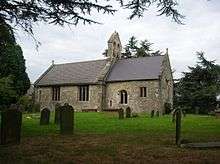
St. Everilda's Church is at the end of Church Lane and is thought to have origins as early as the 7th century.[19] The stained glass in the eastern window and in one of the windows in the south aisle is of late 13th century and early 14th century. St Everilda's Church is named after a 7th-century Saxon saint. It is one of only two churches in the United Kingdom dedicated to this saint. The other is at Everingham some 20 miles (32 km) to the south-east in the East Riding of Yorkshire.[20]
Sports
The local football team, Poppleton United, and a lawn tennis club are in nearby Upper Poppleton. In addition there is a Junior Football club, Poppleton Tigers, based on Millfield Lane. The team play at the Poppleton Community Sports Pavilion, which was opened by John Sentamu, Archbishop of York on 10 October 2011.[21]
References
- ↑ "Census 2001: Parish Headcounts: York". Neighbourhood Statistics. Office for National Statistics. Retrieved 13 July 2012.
- ↑ "Civil Parish population 2011". Neighbourhood Statistics. Office for National Statistics. Retrieved 19 February 2016.
- 1 2 3 "Origin of name". Retrieved 14 November 2010.
- 1 2 "Scheduled Monument". Retrieved 19 November 2010.
- ↑ "Time Team". Retrieved 8 February 2012. For video on 4OD see http://www.channel4.com/programmes/time-team/4od#2929881
- 1 2 Bulmer's Topography, History and Directory (Private and Commercial) of North Yorkshire 1890. S&N Publishing. 1890. p. 882. ISBN 1-86150-299-0.
- ↑ Bulmer's Topography, History and Directory (Private and Commercial) of North Yorkshire 1890. S&N Publishing. 1890. p. 882. ISBN 1-86150-299-0.
- ↑ "Civil War". Retrieved 14 November 2010.
- ↑ The York, Knaresborough and Harrogate Railway. C.T.Goode. 2001. ISBN 1-870313-22-4.
- ↑ "Time Team". Retrieved 19 November 2010. For video on 4OD see http://www.channel4.com/programmes/time-team/4od#2929881
- ↑ "Councillors". Retrieved 6 November 2010.
- ↑ "Parish Council". Retrieved 14 November 2010.
- ↑ "Primary education". Retrieved 14 November 2010.
- ↑ "Secondary Education" (PDF).
- ↑ "Manor CE School Admissions". Retrieved 14 November 2010.
- ↑ "Manor CE School". Retrieved 14 November 2010.
- ↑ "Transport". Archived from the original on 28 October 2009. Retrieved 8 November 2010.
- ↑ "Rail links". Retrieved 14 November 2010.
- ↑ "Church History" (PDF). Retrieved 19 November 2010.
- ↑ "Local Church". Retrieved 19 November 2010.
- ↑ "New Sports Pavilion". Retrieved 11 October 2012.
External links
- Nether Poppleton Parish Council website
- The ancient parish of Nether Poppleton: historical and genealogical information at GENUKI.
![]() Media related to Nether Poppleton at Wikimedia Commons
Media related to Nether Poppleton at Wikimedia Commons