Nevada State Route 430
U.S. Route 395 Business | ||||
|---|---|---|---|---|
| Virginia Street | ||||
| Route information | ||||
| Maintained by NDOT | ||||
| Length: |
3.161 mi[1] (5.087 km) Length of US 395 Bus. not included in this figure | |||
| Existed: | 1976 – present | |||
| Major junctions | ||||
| South end: |
| |||
| North end: |
| |||
| Highway system | ||||
| ||||


State Route 430 (SR 430) is a north–south state highway in Reno, Washoe County, Nevada. On the north end of the city, the highway follows Virginia Street, the primary north–south arterial street of the area. SR 430 is also designated as U.S. Route 395 Business within Reno city limits—the business route extends along the entirety of Virginia Street in the city of Reno, although the designation is mostly unsigned.
SR 430 was previously a much longer route, extending from the northern reaches of Reno all the way through Washoe City along Virginia Street and the Carson–Reno highway. The entirety of the route formerly served as the mainline alignment of U.S. Route 395 (US 395) before being bypassed by freeway segments. Most of SR 430 has gradually been phased out by either being turned over to local control or becoming part of U.S. Route 395 Alternate.
Route description
US 395 Business
_at_California_Avenue_in_Reno%2C_Nevada.jpg)
As Virginia Street passes north under Interstate 580 (I-580) and US 395 freeway on the south end of Reno, the U.S. Route 395 Business designation begins along the road (concurrent with US 395 Alt.). The roadway turns slightly westward as it travels further north into Reno. In about three miles (5 km), the highway again meets the I-580 / US 395 freeway. The alternate route ends just north of here, at the intersection with Patriot Boulevard; US 395 Business, however continues to follow Virginia Street northward.
Beyond the terminus of the alternate route, businesses appear more frequently along the arterial. Large retail stores, shopping malls and restaurants begin to line the sides of the business route. After passing another interchange with I-580 / US 395 and the junction with Kietzke Lane, the Reno-Sparks Convention Center can be seen along the east side of the road, along with larger casino properties and additional businesses as the route continues north. Passing north of California Avenue, Virginia Street narrows down and reaches Downtown Reno. Seen amongst other businesses along the highway are major office buildings, government institutions, and cultural centers.
In the center of Reno, US 395 Business crosses over the Truckee River on the Virginia Street Bridge. The river crossing dates back to 1860, prior to the Reno's existence as "Lake's Crossing".[2] The current structure, built in 1905 as the fifth bridge at this location, is the oldest bridge in Reno and was one of the first reinforced concrete bridges built in Nevada. Designed by John B. Leonard, the structure includes etchings to resemble masonry.[3] Since 1992, the bridge structure has been declared structurally deficient due to its impedance of high water flows on the Truckee. Balancing the structure's historic status with the required flood water flow conveyance has stalled rehabilitation or replacement of the structure.[4]
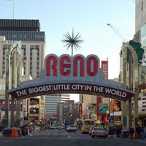
On the opposite side of the river crossing, US 395 Business enters the downtown core. Each side of the highway is lined with numerous casinos and small businesses. Portions of Virginia Street between First Street and Sixth Street are frequently closed to vehicular traffic (most often in the summertime) to host special events that attract tourists and locals to the downtown area; such events include Hot August Nights, Street Vibrations, parades, and other activities. A notable landmark along this stretch of roadway is the Biggest Little City in the World sign. Located at Virginia Street and Commercial Row (just south of Third Street), the current version of this famous arch was erected in 1987.[5]
North of downtown, the business route intersects I-80 as it heads away from the casinos. Just past the Interstate, US 395 Business encounters the University of Nevada, Reno campus. Academic buildings, residence halls, the student union, Lawlor Events Center and Fleischmann Planetarium are several of the university buildings visible from Virginia Street, which follows the western border of the campus.
State Route 430
_in_Reno%2C_Nevada.jpg)
State Route 430 begins as Virginia Street crosses North McCarran Boulevard (State Route 659). Roadside businesses taper off as the route travels north out of Reno, paralleling the Union Pacific railroad tracks heading towards northern California. Both SR 430 and US 395 Business terminate at the route's final interchange with US 395 near Panther Valley north of Reno.
History
SR 430 is the original routing of US 395 through the Reno area. The US 395 designation was removed from Virginia Street and added to the new highway segmentally as new stretches of freeway were completed. SR 430 was designated as US 395 Business for some time after the freeway was completed. By 2001, any Business US 395 shields on Virginia Street had been removed; however, a few business shields remain on older overhead guide signs in the Reno area.
In 2001, the gap between the two segments of SR 430 along Virginia Street was much smaller. The southern section had a northern terminus at the intersection with Plumb Lane (SR 653). However, the state maintained part of South Virginia Street was truncated to the I-580 half interchange by 2006. More of SR 430 was given to local control by 2008, when the northern terminus of the southern section was moved to Patriot Boulevard. Also in 2001, the northern segment of SR 430 had a southern terminus at I-80. However, the portion of North Virginia Street along the west edge of the University of Nevada, Reno between I-80 and North McCarran Boulevard (SR 659) was relinquished to the City of Reno by January 2008.[6]
Major intersections
The major intersections table lists junctions for both U.S. 395 Business and State Route 430. Mileposts for both routes are continuous and based on the former alignment of U.S. Route 395.
The entire route is in Reno, Washoe County.
| mi | km | Destinations | Notes | ||
|---|---|---|---|---|---|
| 17.00 | 27.36 | South end of US 395 Bus.; South end of US 395 Alt. overlap | |||
| South Meadows Parkway (SR 426) | |||||
| 19.80 | 31.87 | Holcomb Ranch Lane (SR 671) | |||
| 20.10 | 32.35 | ||||
| Patriot Boulevard | North end of US 395 Alt. overlap | ||||
| 22.30 | 35.89 | S. McCarran Boulevard (SR 659) | |||
| 22.70 | 36.53 | Kietzke Lane (SR 667) | |||
| 24.29 | 39.09 | Plumb Lane | To Reno-Tahoe International Airport; former SR 653 | ||
| Virginia Street Bridge over the Truckee River | |||||
| W. 4th Street (I-80 Bus.) | Former US 40 | ||||
| 25.57 | 41.15 | N. McCarran Boulevard (SR 659) | South end of SR 430 | ||
| N. Virginia Street, Panther Drive | Former US 395 north | ||||
| North end of US 395 Bus. and SR 430 | |||||
1.000 mi = 1.609 km; 1.000 km = 0.621 mi
| |||||
See also
 Nevada portal
 U.S. Roads portal
References
- ↑ Nevada Department of Transportation (January 2013). "State Maintained Highways of Nevada: Descriptions and Maps". Retrieved January 26, 2013.
- ↑ "History of Virginia Street Bridge". City of Reno. 2008-07-29. Retrieved 2009-01-09.
- ↑ "Virginia Street Bridge". Three Historic Nevada Cities: Carson City, Reno, Virginia City. National Park Service. Retrieved 2009-01-09.
- ↑ "Background - Virginia Street Bridge". City of Reno. 2008-08-01. Retrieved 2009-01-09.
- ↑ "Reno Arch History Downtown". New To Reno.com. Retrieved 2009-01-09.
- ↑ Nevada Department of Transportation (January 2008). "Nevada State Maintained Highways: Descriptions, Index and Maps". Retrieved 2009-01-08.