Interstate 580 (Nevada)
| ||||
|---|---|---|---|---|
_map.svg.png) | ||||
| Route information | ||||
| Maintained by NDOT | ||||
| Length: | 30.090 mi[1] (48.425 km) | |||
| Existed: | October 27, 1978 – present | |||
| History: | Number approved on October 27, 1978; constructed in phases 1964–2012; signed in 2012 | |||
| Major junctions | ||||
| South end: |
| |||
| ||||
| North end: |
| |||
| Highway system | ||||
| ||||
.svg.png)
Interstate 580 (I-580) is an Interstate Highway in northwestern Nevada. It runs concurrently with U.S. Highway 395 (US 395) from I-80 in Reno, to the east leg of US 50 in Carson City. Although the freeway has existed in Reno with the I-580 designation since the 1970s, the Interstate was signed only as US 395 until the portion between Reno and Carson City was completed in 2012. I-580 is not complete; the highway is expected to be signed between the east and west legs of US 50 in Carson City, however the final phase of freeway construction between Fairview Drive and US 50 west has been postponed several times with an uncertain completion date.
Route description
I-580 is still under development. The freeway exists today from I-80 near downtown Reno south to Fairview Drive in Carson City. Eventually, the highway will continue in a southerly direction from Fairview Drive to terminate at the junction of US 395 and US 50 just south of Carson City. Fairview Drive is being temporarily used as a connector to Carson Street and US 395.
The constructed portion begins at Fairview Drive along the eastern edge of Eagle Valley, where most of the population of Carson City lives. The highway loosely follows the former alignments of Edmonds Drive and Lompa Lane along the eastern half of the city, which were relocated or truncated to make room for the freeway.
After rejoining the original alignment of US 395 near the Carson Tahoe Regional Medical Center, the highway crests Lakeview Hill to enter the Washoe Valley. The portion of I-580/US 395 and US 395 Alternate through Washoe Valley are prone to high crosswinds and, as such, the highways are frequently closed to high-profile vehicles. During prohibited times, trucks are re-routed to Eastlake Boulevard and U.S. Route 395 Alternate, which is the old routing of US 395. The high wind area ends near the Bowers Mansion interchange near the northern end of the Washoe Valley.
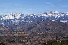
Unlike the old US 395 which ran along the valley floor of Pleasant Valley, I-580 is routed in the mountains overlooking the valley. While traversing Pleasant Valley, the highway crosses the Galena Creek Bridge, the largest cathedral arch bridge in the world. Upon the descent from these mountains the highway cuts through the center of one of the largest geothermal power plants in the United States, Ormat Industries' Nevada Power station, just before entering Reno.
_in_Reno%2C_Nevada.jpg)
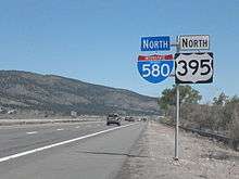
At the extreme southern edge of Reno, the highway has a junction with the Mount Rose Highway (SR 431) and Geiger Grade (SR 341), which connect the freeway with North Lake Tahoe and Virginia City, respectively. Upon entering Reno, the freeway proceeds in a generally northern direction, crossing Virginia Street, the old routing of US 395, several times. Along the way the freeway passes to the side of the The Summit Sierra Mall, Meadowood Mall and Reno–Tahoe International Airport. The I-580 designation ends at the Reno Spaghetti Bowl where the highway crosses I-80; however, the freeway continues on only as US 395, heading towards the north valley neighborhoods of Sun Valley, Lemon Valley and Stead before eventually crossing the California state line.
Named sections
The freeway has two memorial designations, within the Reno city limits the freeway is designated the Martin Luther King Jr. freeway. Within the Carson City limits the freeway is designated the Carson City Deputy Sheriff Carl Howell Memorial Freeway in honor of a sheriff's officer who was fatally shot while attempting to extricate a victim of domestic violence from their house.[2][3]
History
Development of the I-580/US 395 freeway has been in planning since 1956, but significant construction did not occur until over a decade later. Below is a timeline of the opening dates of the current freeway segments that are or will be part of I-580.[4]
- 1964–1970: Winters Ranch area (junction Carson–Reno Highway / US 395 and Old Highway 395 / SR 429) south to Washoe Valley—Washoe County—Carson City line
- 1973: Reno—Panther Valley (Exit 72) south to East 2nd Street / Glendale Avenue (Exit 67), only the portion of this segment between I-80 and East 2nd Street / Glendale Avenue was designated as I-580; the remainder was and remains signed only as US 395
- 1978: Reno—East Second Street / Glendale Avenue (Exit 67) south to Mill Street (Exit 66)
- 1979: Reno—Mill Street (Exit 66) south to Plumb Lane / Villanova Drive (Exit 65)
- 1981: Reno—Plumb Lane / Villanova Drive (Exit 65) south to South Virginia Street (at the Exit 63 half-interchange)
- 1986: Reno—South Virginia Street (Exit 63) to Del Monte Lane, now Neil Road (Exit 62)
- 1989: Reno—Del Monte Lane, now Neil Road (Exit 62) south to South Virginia Street (at Exit 61)
- 1996: Reno—South Virginia Street (Exit 61) south to SR 431 / Mount Rose Highway (Exit 56)
- 2006: Carson City—Washoe County—Carson City line: North Carson Street (Exit 43) south to US 50 east / East William Street (Exit 39)
- 2009: Carson City—US 50 east / East William Street (Exit 39) south to Fairview Drive (Exit 38)
- 2012: Steamboat Hills—Winters Ranch area: SR 431 / Mount Rose Highway (Exit 56) south to US 395 Alt. / Bowers Mansion Road (Exit 50)
- 2017: Carson City—Fairview Drive (Exit 38) south to South Carson Street (Exit 35)
The I-580 designation was first approved by the American Association of State Highway and Transportation Officials (AASHTO) on October 27, 1978; at the time, this route extended from I-80 to US 395 (South Virginia Street, at the current exit 63).[5] AASHTO approved the remainder of planned I-580, to the future southern terminus at US 395 south of Carson City, at its December 7, 1984, meeting.[6] Despite the route number being approved and being shown on some maps in the 1980s, I-580 was not signed along the Interstate until the freeway gap between Mount Rose Highway and Bowers Mansion Road was completed in 2012.
The segment completed in 2012 connected Carson City to the Interstate Highway system, leaving four state capitals not served by the Interstate Highway System: Dover, Delaware, Juneau, Alaska, Pierre, South Dakota and Jefferson City, Missouri.
Future
The remaining portion of I-580 that is not complete is what the Nevada Department of Transportation (NDOT) has internally designated as phase 2B of the Carson City Freeway. Phase 2B will complete the remaining freeway to US 50 west, including the interchange with US 395 and South Carson Street. Construction of Phase 2A finished in September 2009;[7] however, construction of Phase 2B has been split into four sub-phases. Phase 2B-2 (Snyder Avenue Bridge, Grading and Drainage Improvements) was completed in the middle of 2014. Phase 2B-3 (completion of the existing freeway to an interim grade crossing at South Carson Street) began in 2015 with completion expected in 2017. Phase 2B-4 (which would build the South Carson Street interchange and complete the freeway) does not have an estimated date of completion.[8]
Exit list
For other exits on US 395, see U.S. Route 395 in Nevada.
| County | Location | mi | km | Exit[lower-alpha 1] | Destinations | Notes |
|---|---|---|---|---|---|---|
| City of Carson City 0.00–9.56 | — | Continuation beyond US 50 east | ||||
| 39 | Southern end of I-580 | |||||
| 41 | College Parkway | Serves Carson Airport and Western Nevada College | ||||
| 42 | Arrowhead Drive | Northbound exit and southbound entrance; serves Carson Tahoe Regional Medical Center | ||||
| 43 | Southbound exit and northbound entrance; serves Carson Tahoe Regional Medical Center | |||||
| Washoe 0.00–42.10 | Washoe Valley | 44 | Eastlake Boulevard (to US 395 Alt.) | Serves Washoe Lake State Park | ||
| 46 | Bellevue Road | |||||
| Washoe City | 50 | Old US 395 (US 395 Alt., Bowers Mansion Road, Carson–Reno Highway) – Washoe City | Serves Bowers Mansion | |||
| Pleasant Valley | Galena Creek Bridge | |||||
| Reno | 56 | Also serves SR 341 (Geiger Grade) to Virginia City | ||||
| 57B | S. Virginia Street south (US 395 Alt. south) – Virginia City, Washoe City | Southbound exit and northbound entrance | ||||
| 57A | S. Virginia Street north (US 395 Alt. north / US 395 Bus. north) | Southbound exit and northbound entrance | ||||
| 59 | Damonte Ranch Parkway | |||||
| 60 | South Meadows Parkway (SR 426 west) | |||||
| 61 | S. Virginia Street (US 395 Alt. / US 395 Bus.) | |||||
| 62 | Neil Road, Meadowood Mall Way | |||||
| 63 | S. Virginia Street (US 395 Bus.), Kietzke Lane | Southbound exit and northbound entrance | ||||
| 64 | Moana Lane | Serves Reno-Sparks Convention Center | ||||
| 65 | Signed as exits 65A (Villanova Drive, Plumb Lane) and 65B (airport) southbound | |||||
| 66 | Mill Street | Serves Renown Regional Medical Center | ||||
| 67 | E. Second Street, Glendale Avenue (SR 648) | |||||
| 68 | Northern end of I-580; signed as exits 68A (east) and 68B (west) northbound; I-80 exit 15 | |||||
| — | Continuation beyond I-80 | |||||
| 1.000 mi = 1.609 km; 1.000 km = 0.621 mi | ||||||
See also
-
 Nevada portal
 -
 U.S. Roads portal
Notes
- ↑ Exits are numbered using cumulative mileage along US 395 from the California–Nevada border near Topaz Lake.
References
- ↑ Nevada Department of Transportation (January 2013). "State Maintained Highways of Nevada: Descriptions and Maps". Nevada Department of Transportation. Retrieved January 26, 2013.
- ↑ Munson, Jeff (December 8, 2015). "Stretch of Carson City Freeway Officially Named in Honor of Deputy Carl Howell". Carson Now. Retrieved December 8, 2015.
- ↑ Munson, Jeff (August 16, 2015). "Carson City Deputy Killed in the Line of Duty Identified". Carson Now. Retrieved December 8, 2015.
- ↑ Nevada Department of Transportation. "History & Overview". I-580 Extension Project website. Nevada Department of Transportation. Archived from the original on May 27, 2008. Retrieved September 11, 2008.
- ↑ Special Committee on U.S. Route Numbering (October 28, 1978). "Route Numbering Committee Agenda Showing Action Taken by the Executive Committee" (PDF) (Report). Louisville, KY: American Association of State Highway and Transportation Officials. Retrieved November 7, 2014 – via Wikimedia Commons.
- ↑ Special Committee on U.S. Route Numbering (December 7, 1984). "Route Numbering Committee Agenda" (PDF) (Report). New Orleans, LA: American Association of State Highway and Transportation Officials. Retrieved November 7, 2014 – via Wikimedia Commons.
- ↑ Norton, F.T. (September 24, 2009). "New Bypass Opens Today". Nevada Appeal. Retrieved January 20, 2010.
- ↑ author (August 22, 2015). "Carson City Freeway". Carson City Freeway project Web page. Nevada Department of Transportation. Retrieved December 8, 2015.
External links
| Wikimedia Commons has media related to Interstate 580 (Nevada). |
| ||