Nevada State Route 88
| ||||
|---|---|---|---|---|
| Woodfords Road | ||||
 | ||||
| Route information | ||||
| Maintained by NDOT | ||||
| Length: | 7.868 mi[1] (12.662 km) | |||
| Existed: | 1957 – present | |||
| History: | Established as SR 37 by 1935 | |||
| Major junctions | ||||
| South end: |
| |||
| North end: |
| |||
| Location | ||||
| Counties: | Douglas | |||
| Highway system | ||||
| ||||

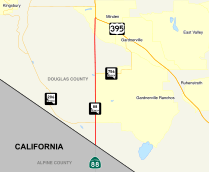
State Route 88 (SR 88) is a state highway in Douglas County, Nevada. It runs from the California state line along Woodfords Road to U.S. Route 395 in Minden. Prior to 1957, the highway existed as State Route 37. The highway continues into California as California State Route 88; both highways are closely related. Although Route 88 is a secondary route today, the highway is a historical route from when Carson Pass was a major crossing of the Sierra Nevada.
Route description
_in_Douglas_County%2C_Nevada.jpg)
The route enters Nevada from California near Woodfords, California. Just after exiting the Sierra Nevada via the Carson River. The road loosely follows the river, and the Carson Valley on the western edge of communities of Gardnerville, Centerville and Minden where the highway ends at a Y junction with U.S. Route 395. Despite the fact that California State Route 88 is an east-west highway, Nevada State Route 88 follows a nearly straight north-south path.
History
The highway shares much of its history with its California counterpart. Both formed part of a trail that went under such names as "Emigrant Trail", "Kit Carson Emigrant Trail" which has existed since the 1840s.[2] The Carson Pass route was one of two primary divisions of the California Trail. The trail's use diminished with the establishment of the First Transcontinental Railroad which was completed in 1869, and follows a path closer to modern Interstate 80 across the Sierra Nevada.[2] Newer names for the road have included "Carson Pass Road" after Carson Pass in California.
Woodsford Road first appears on state maps in 1934 as a gravel and graded highway.[3] By 1935, State Route 37 had been established along the roadway.[4] The route remained unchanged until being renumbered as State Route 88 by 1957.[5]
Major intersections
The entire route is in Douglas County.
| Location | mi[1] | km | Destinations | Notes | |
|---|---|---|---|---|---|
| | 0.00 | 0.00 | Continuation beyond California state line | ||
| | |||||
| Gardnerville | |||||
| Minden | 7.868 | 12.662 | |||
| 1.000 mi = 1.609 km; 1.000 km = 0.621 mi | |||||
See also
 Nevada portal
 U.S. Roads portal
References
- 1 2 "Nevada's State Maintained Highways, Descriptions, Index & Maps" (PDF). Nevada Department of Transportation. Retrieved 2008-05-24.
- 1 2 Kyle, Douglas E.; Hoover, Mildred Brooke (2002). Historic Spots in California. Stanford University Press. p. 29. ISBN 0-8047-4483-1.
- ↑ Official Road Map of Nevada (Map). Nevada State Highway Department. 1934. Retrieved 2008-05-24.
- ↑ Road Map of the State of Nevada (Map). Nevada State Highway Department. 1935. Retrieved 2008-05-24.
- ↑ Official Highway Map of Nevada (Map). Nevada Department of Highways. 1957. Retrieved 2008-05-24.