New York State Route 199
| ||||
|---|---|---|---|---|
|
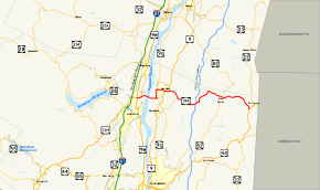
Map of the Mid-Hudson Valley with NY 199 highlighted in red | ||||
| Route information | ||||
| Maintained by NYSDOT and NYSBA | ||||
| Length: | 30.91 mi[1] (49.74 km) | |||
| Existed: | 1930[2] – present | |||
| Major junctions | ||||
| West end: |
| |||
|
| ||||
| East end: |
| |||
| Location | ||||
| Counties: | Ulster, Dutchess | |||
| Highway system | ||||
| ||||

New York State Route 199 (NY 199) is a state highway located in the Hudson Valley of New York in the United States. It extends for 30.91 miles (49.74 km) from an interchange with U.S. Route 9W (US 9W) and US 209 north of Kingston to an intersection with US 44 and NY 22 southwest of Millerton. In between, NY 199 crosses over the Hudson River by way of the Kingston–Rhinecliff Bridge and passes through the communities of Red Hook and Pine Plains. NY 199 meets US 9 in Red Hook and the Taconic State Parkway midway between Red Hook and Pine Plains.
The portion of NY 199 east of its junction with the Taconic State Parkway was originally part of the Ulster and Delaware Turnpike, a toll road linking Bainbridge to Salisbury, Connecticut. This segment of the turnpike was incorporated into New York State Route 41, a new route connecting Barrytown to Millerton, in the mid-1920s. NY 41 was renumbered to NY 199 as part of the 1930 renumbering of state highways in New York.
When the Kingston–Rhinecliff Bridge opened in 1957, NY 199 was realigned to continue across the bridge to the town of Ulster. The former routing of NY 199 between Barrytown and NY 9G along Barrytown Road remained state maintained until 1980, when ownership and maintenance of the highway was transferred to Dutchess County. It is now designated as County Route 82 (CR 82).
Route description
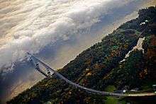
NY 199's western terminus is at a cloverleaf interchange with US 9W in the town of Ulster, situated just north of the city of Kingston and south of the hamlet of Lake Katrine. US 209 ends here and becomes NY 199. The portion of US 209 near Kingston is a four-lane limited-access highway, and the first mile (1.6 km) of NY 199 serves as a continuation of the expressway. NY 199 has one interchange with NY 32 before narrowing to two lanes as it approaches the Hudson River. The route crosses the river by way of the Kingston–Rhinecliff Bridge, a two-lane toll bridge linking the towns of Ulster and Rhinebeck.[3]
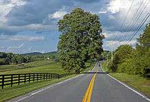
Now on the eastern bank of the river, NY 199 heads eastward for 1.5 miles (2.4 km) through forested areas to an intersection with NY 9G near the Rhinebeck–Red Hook town line. NY 199 turns northward, overlapping NY 9G through southern Red Hook. The two routes separate east of the hamlet of Barrytown. While NY 9G continues northward, NY 199 heads east through the village of Red Hook and across the hills and fields of northern Dutchess County, coming within 2 miles (3 km) of the Old Rhinebeck Aerodrome aviation museum (via Orlick & Norton Road) south of it. Along the way, NY 199 intersects US 9 in Red Hook and the Taconic State Parkway in Milan. Past the latter, it enters the hamlet of Pine Plains, where it is joined by NY 82 from the south. Together, the two highways form the main street of Pine Plains before separating in a more wooded area just east of the community.[3]
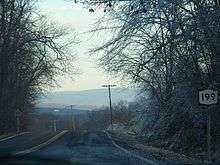
East of Pine Plains, the route passes through mostly wooded areas until it reaches the upper Harlem Creek valley. Here, NY 199 turns to the southeast and descends into the valley as it enters the town of North East. The route ends 2.5 miles (4.0 km) to the southeast at an obliquely-angled junction with US 44 and NY 22 southwest of the village of Millerton.[3]
History
Origins and designation
On April 2, 1802, the New York State Legislature created a turnpike corporation for the purpose of building a road—the Ulster and Delaware Turnpike—from the Susquehanna River in the vicinity of the town of Jericho (now Bainbridge) to the Connecticut state line at Salisbury.[4] The portion of the Ulster and Delaware Turnpike east of the Hudson River was also commonly known as the "Ulster and Salisbury Turnpike" or just the "Salisbury Turnpike". The turnpike crossed the Hudson River from Kingston to Rhinecliff by way of the Kingston–Rhinecliff Ferry and used modern Rhinecliff Road and West Market Street to reach the village of Rhinebeck. East of Rhinebeck, the turnpike passed through the hamlets of Eighmyville, Milan, Lafayetteville, and Pine Plains and the village of Millerton on its way to the Connecticut border.[5] The turnpike corporation operated through the late 19th century.
In the mid-1920s, the portion of the Ulster and Delaware Turnpike from Lafayetteville to modern NY 22 in North East was designated as part of NY 41, a new route extending from Barrytown, a riverside hamlet 6 miles (10 km) north of Rhinecliff, to North East by way of Red Hook, Lafayetteville, and Pine Plains.[6][7] The designation lasted for only half a decade as NY 41 was renumbered to NY 199 as part of the 1930 renumbering of state highways in New York.[2]
Kingston–Rhinecliff Bridge
Initial plans for the Kingston–Rhinecliff Bridge, a structure that replaced the ferry between the two locations, called for the bridge to span the Hudson River between downtown Kingston (at Kingston Point) and the village of Rhinebeck along a corridor similar to that of then-NY 308. Due to political and economic factors, the bridge site was moved 3 miles (5 km) upstream (northward).[8] The partially completed bridge opened to traffic on February 2, 1957,[9] as a realignment and extension of NY 199. The route left its original alignment east of Barrytown and followed NY 9G southward to the eastern bridge approach in the town of Rhinebeck. From there, NY 199 crossed the new bridge and ended at a junction with NY 32 just west of the Hudson River, then the western endpoint of the Kingston bridge approach. An extension of NY 199 west to US 9W was completed in the late 1950s.[10][11]
The original routing of NY 199 from the Hudson River at Barrytown to NY 9G remained state-maintained as a reference route for just over two decades. On April 1, 1980, ownership and maintenance of the highway, named Barrytown Road, was transferred from the state of New York to Dutchess County as part of a highway maintenance swap between the two levels of government.[12] Barrytown Road is now designated as CR 82.[13]
Major intersections
| County | Location | mi[1] | km | Destinations | Notes |
|---|---|---|---|---|---|
| Ulster | Ulster | 0.00 | 0.00 | Cloverleaf interchange; northern terminus of US 209 | |
| 0.98 | 1.58 | Parclo interchange | |||
| Hudson River | 1.37 | 2.20 | Kingston–Rhinecliff Bridge | ||
| Dutchess | Town of Red Hook | 4.44 | 7.15 | Southern terminus of NY 9G / NY 199 overlap | |
| 6.39 | 10.28 | Northern terminus of NY 9G / NY 199 overlap | |||
| Village of Red Hook | 8.15 | 13.12 | |||
| Milan | 11.91 | 19.17 | Hamlet of Rock City; eastern terminus of NY 308 | ||
| 15.63 | 25.15 | ||||
| Town of Pine Plains | 22.58 | 36.34 | Hamlet of Pine Plains; western terminus of NY 82 / NY 199 overlap | ||
| 24.01 | 38.64 | Eastern terminus of NY 82 / NY 199 overlap | |||
| North East | 30.91 | 49.74 | |||
1.000 mi = 1.609 km; 1.000 km = 0.621 mi
| |||||
See also
References
- 1 2 "2008 Traffic Data Report for New York State" (PDF). New York State Department of Transportation. June 16, 2009. p. 263. Retrieved October 5, 2009.
- 1 2 Dickinson, Leon A. (January 12, 1930). "New Signs for State Highways". The New York Times. p. 136.
- 1 2 3 Google (October 4, 2009). "overview map of NY 199" (Map). Google Maps. Google. Retrieved October 4, 2009.
- ↑ State of New York (1804). Laws of the State of New York, Vol. III. Albany, New York: Charles R. and George Webster. p. 113. OCLC 65113901.
- ↑ Sive, Mary Robinson (1998). Lost Villages: Historic Driving Tours in the Catskills. Delhi, New York: Delaware County Historical Association. ISBN 1-892289-00-8. OCLC 39778943.
- ↑ "New York's Main Highways Designated by Numbers". The New York Times. December 21, 1924. p. XX9.
- ↑ Rand McNally Auto Road Atlas (eastern New York) (Map). Rand McNally and Company. 1926. Retrieved October 5, 2009.
- ↑ "The "George Clinton" Kingston–Rhinecliff Bridge". New York State Bridge Authority. Retrieved October 5, 2009.
- ↑ Kaplan, Morris (February 3, 1957). "Harriman Opens Kingston Bridge". The New York Times. p. 59.
- ↑ New York with Special Maps of Putnam–Rockland–Westchester Counties and Finger Lakes Region (Map) (1958 ed.). Cartography by General Drafting. Esso. 1958.
- ↑ New York and New Jersey Tourgide Map (Map). Cartography by Rand McNally and Company. Gulf Oil Company. 1960.
- ↑ New York State Legislature. "New York State Highway Law § 341". Retrieved October 5, 2009.
- ↑ Saugerties Digital Raster Quadrangle (Map). 1:24,000. New York State Department of Transportation. 1989. Retrieved October 5, 2009.
External links
| Wikimedia Commons has media related to New York State Route 199. |
- New York State Route 199 at Alps' Roads • New York Routes • New York State Highway Termini • Upstate New York Roads
- Kingston–Rhinecliff Bridge @ NYCROADS.com
- Unbuilt Catskill Expressway @ NYCROADS.com