New York State Route 206
| |||||||
|---|---|---|---|---|---|---|---|
|
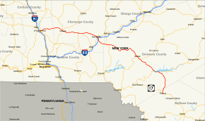
Map of south central New York with NY 206 highlighted in red | |||||||
| Route information | |||||||
| Maintained by NYSDOT, NYCDOT, Delaware County, and Sullivan County | |||||||
| Length: | 74.57 mi[1] (120.01 km) | ||||||
| Existed: | 1930[2] – present | ||||||
| Major junctions | |||||||
| West end: |
| ||||||
|
| |||||||
| East end: |
| ||||||
| Location | |||||||
| Counties: | Broome, Chenango, Delaware, Sullivan | ||||||
| Highway system | |||||||
| |||||||

New York State Route 206 (NY 206) is a state highway in the Southern Tier of New York in the United States. It runs through some lightly populated regions along the state's southern border, from Central New York to the Catskills. It begins near a busy intersection with Interstate 81 (I-81) at Whitney Point and runs east from there through Greene. The eastern terminus is located at a junction with NY 17 (future I-86) at Roscoe in Sullivan County. It is one of the longest three-digit routes in New York, and the only long one not associated with a two-digit route or a former U.S. Route. Yet due to its location it sees little traffic, although for much of its length it follows the route of a main 19th century thoroughfare, the Catskill Turnpike. It is primarily a long shortcut around Binghamton.
NY 206 was assigned as part of the 1930 renumbering of state highways in New York, but only from Bainbridge to Downsville. NY 206 was extended west to Whitney Point in the early 1940s; another extension in the late 1970s moved the route's eastern terminus to Roscoe. Prior to becoming NY 206, the Whitney Point–Greene segment was once New York State Route 219 and New York State Route 383 while the portion from Coventry to Bainbridge was previously New York State Route 218.
Route description

Broome County
Signs on I-81 include 206 along with the other highways at the Whitney Point exit even though it actually begins at NY 79 a short distance east of the interstate. From there it crosses the town of Triangle prior to entering Chenango County.
Chenango County
In the village of Greene, NY 206 intersects with NY 12 downtown. NY 41 also joins 206 here.
Upon leaving Greene, the concurrent routes cross the Chenango River and head east through rural areas across the county. Both proceed into the town of Coventry, where NY 235 drops off to the south in the hamlet of Coventry, followed a few miles later by 41 in Coventryville.
At the next village, Bainbridge, 206 intersects NY 7 in the center of town, then crosses the Susquehanna River to its exit with I-88. After a short stretch heading south from here, 206 turns east once again to enter Delaware County.
Delaware and Sullivan counties
The farms along the road become bigger and the houses fewer as the road begins to climb gently into the Catskill Plateau. At Masonville, 206 intersects another major north–south trunk route, NY 8, after which it begins to head south, making its way over the ridges and through valleys to Walton, a small mountain town that hosts the Delaware County Fair every summer.

It shares that mountain town's main street with NY 10 for several blocks, then leaves it to cross the West Branch of the Delaware River and climb into the mountains to the southeast. Here it passes one of the largest tracts of state-owned land in the county outside the nearby Catskill Park, the Bear Spring Mountain Game Preserve, a popular hunting destination.
Descending once again, 206 meets NY 30 in the hamlet of Downsville. Leaving town, the two highways cross the Delaware's East Branch, and thus the Blue Line, entering the Catskill Park.
After following 30 a short distance along Pepacton Reservoir, 206 once again heads up into the hills. This stretch brings it ultimately into Sullivan County, where it ends in downtown Roscoe at the interchange with NY 17.
NY 206 is maintained by Delaware County as County Route 7 (CR 7, named Cat Hollow Road) from NY 30 to the Sullivan County line. It is maintained by Sullivan County as CR 91 (Rockland Road) from the Delaware County line to CR 179 and CR 179A (Old Route 17) and CR 179 (Old Route 17) from CR 91 and CR 179A to NY 17.
History
The stretch of NY 206 from Whitney Point to Bainbridge was once part of the Catskill Turnpike.
NY 206 was assigned as part of the 1930 renumbering of state highways in New York to the portion of its modern alignment between NY 7 in Bainbridge and NY 30 in Downsville. At the same time, the portion of modern NY 206 west of Bainbridge was designated as NY 219 from Whitney Point to Greene, part of NY 41 from Greene to Coventryville, and NY 218 from Coventryville to Bainbridge.[2] When U.S. Route 219 was extended into New York c. 1935, NY 219 was renumbered to NY 383 to eliminate numerical duplication with the new U.S. Highway.[3][4] In the early 1940s, NY 206 was extended west to Whitney Point, supplanting both NY 218 and NY 383.[5][6] The extension was partially reverted on January 1, 1949, as the route was cut back to Greene;[7] however, NY 206 was reextended to Whitney Point in the mid-1950s.[8][9] Another addition in the late 1970s moved the east end of NY 206 from Downsville south to NY 17 in Roscoe.[10][11]
On June 19, 2007, a flash flood along the Beaverkill River and some nearby tributaries along NY 206 near the highway's east end took several lives.[12][13] Several sections of road were washed out and an 8-mile (13 km) portion of NY 206 was closed.[14] The highway reopened to through traffic on November 16, 2007.[15]
Major intersections
| County | Location | mi[1] | km | Destinations | Notes |
|---|---|---|---|---|---|
| Broome | Whitney Point | 0.00 | 0.00 | ||
| Chenango | Village of Greene | 10.81 | 17.40 | Western terminus of NY 41 / NY 206 overlap | |
| Coventry | 18.30 | 29.45 | Northern terminus of NY 235 | ||
| 20.41 | 32.85 | Eastern terminus of NY 41 / NY 206 overlap | |||
| Village of Bainbridge | 27.19 | 43.76 | |||
| Town of Bainbridge | 27.68 | 44.55 | Exit 8 (I-88) | ||
| Delaware | Masonville | 34.27 | 55.15 | ||
| Village of Walton | 49.97 | 80.42 | Western terminus of NY 10 / NY 206 overlap | ||
| 50.46 | 81.21 | Eastern terminus of NY 10 / NY 206 overlap | |||
| Colchester | 60.15 | 96.80 | Hamlet of Downsville; western terminus of NY 30 / NY 206 overlap | ||
| 63.25 | 101.79 | Eastern terminus of NY 30 / NY 206 overlap | |||
| Sullivan | Rockland | 74.57 | 120.01 | Hamlet of Roscoe; exit 94 (NY 17) | |
1.000 mi = 1.609 km; 1.000 km = 0.621 mi
| |||||
See also
- List of county routes in Delaware County, New York
- List of county routes in Sullivan County, New York
References
- 1 2 "2008 Traffic Data Report for New York State" (PDF). New York State Department of Transportation. June 16, 2009. pp. 264–265. Retrieved January 13, 2010.
- 1 2 Road Map of New York (Map). Cartography by General Drafting. Standard Oil Company of New York. 1930.
- ↑ Road Map of New York (Map). Cartography by Rand McNally and Company. Texas Oil Company. 1934.
- ↑ Road Map & Historical Guide – New York (Map). Cartography by Rand McNally and Company. Sun Oil Company. 1935.
- ↑ New York Info-Map (Map). Cartography by Rand McNally and Company. Gulf Oil Company. 1940.
- ↑ New York with Pictorial Guide (Map). Cartography by General Drafting. Esso. 1942.
- ↑ "Highway Route Designations Change Jan. 1". Evening Recorder. Amsterdam, NY. Associated Press. December 9, 1948. p. 19.
- ↑ New York with Special Maps of Putnam–Rockland–Westchester Counties and Finger Lakes Region (Map) (1957 ed.). Cartography by General Drafting. Esso. 1956.
- ↑ New York with Special Maps of Putnam–Rockland–Westchester Counties and Finger Lakes Region (Map) (1958 ed.). Cartography by General Drafting. Esso. 1958.
- ↑ New York (Map) (1977–78 ed.). Cartography by General Drafting. Exxon. 1977.
- ↑ New York (Map). Cartography by General Drafting. Exxon. 1979.
- ↑ Bosch, Adam (July 7, 2007). "FEMA declares Sullivan eligible for disaster aid". Times Herald-Record. Middletown, NY. Retrieved April 2, 2009.
- ↑ Bosch, Adam (June 23, 2007). "Flash flood recovery continues; second body is found". Times Herald-Record. Middletown, NY. Retrieved April 2, 2009.
- ↑ "FEMA OKs $4.5 million for flood repairs in Sullivan, Delaware counties". Times Herald-Record. Middletown, NY. September 27, 2007. Retrieved April 2, 2009.
- ↑ Breakey, Patricia (November 14, 2007). "Flood-ravaged Cat Hollow to reopen Friday". The Daily Star. Oneonta, NY. Retrieved April 2, 2009.
External links
| Wikimedia Commons has media related to New York State Route 206. |
- New York State Route 206 at Alps' Roads • New York Routes • New York State Highway Termini