Roscoe, New York
| Roscoe, New York | |
|---|---|
| CDP | |
|
Aerial view of Roscoe from the south (2013) | |
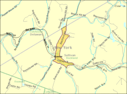 U.S. Census Map | |
 Roscoe, New York Location within the state of New York | |
| Coordinates: 41°56′10″N 74°54′58″W / 41.93611°N 74.91611°WCoordinates: 41°56′10″N 74°54′58″W / 41.93611°N 74.91611°W | |
| Country | United States |
| State | New York |
| County | Sullivan |
| Area | |
| • Total | 0.7 sq mi (1.9 km2) |
| • Land | 0.7 sq mi (1.9 km2) |
| • Water | 0.0 sq mi (0.0 km2) |
| Elevation | 1,296 ft (395 m) |
| Population (2010) | |
| • Total | 541 |
| Time zone | Eastern (EST) (UTC-5) |
| • Summer (DST) | EDT (UTC-4) |
| ZIP code | 12776 |
| Area code(s) | 607 Exchange: 498 |
| FIPS code | 36-63583 |
| GNIS feature ID | 0962895 |
.jpg)
Roscoe is a hamlet (and census-designated place) in Sullivan County, New York, United States. The population was 541 at the 2010 census.
Roscoe is in the southwest part of the Town of Rockland, adjacent to New York State Route 17.
It is named for New York Senator Roscoe Conkling.[1]
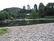
Roscoe calls itself the "Trout Town, USA." The town is a destination for fly-fishing enthusiasts because of its location at the intersection of two rivers popular for trout fishing (the Beaver Kill and the Willowemoc Creek). The community is a traditional stopping point for people traveling along Route 17 (between New York City and Binghamton, New York) because the facilities are right by the access road to the highway. These include gas stations and convenience stores.
History
In 1789 Roscoe was called Westfield Flats. It was the home of the Delaware Indians, where wolves roamed freely.
Roscoe, like most of the Catskills, was part of the Hardenbergh Patent in the early 18th century which in turn was purchased by the last Lord of the Manor of Livingston Manor, Robert Livingston. The first settlers were brothers who bought the area around Roscoe from Livingston's son Jonathan Livingston. Stewart Street is one of the community's main streets. [1]
During the construction of New York State Route 17 (Southern Tier Expressway), the section near Roscoe was one of the last to be completed, requiring travelers to exit onto the local truck roads for several miles.
The Dundas Castle and Roscoe Presbyterian Church and Westfield Flats Cemetery are listed on the National Register of Historic Places.[2]
Geography
Roscoe is located at 41°56′10″N 74°54′58″W / 41.936128°N 74.916121°W.[3]
According to the United States Census Bureau, the CDP has a total area of 0.7 square miles (1.8 km2), all land.
Roscoe is just inside the boundary of the Catskill Park and is at the junction of Beaver Kill and Willowemoc Creek.
Demographics
As of the census[4] of 2000, there were 597 people, 261 households, and 157 families residing in the CDP. The population density was 801.6 per square mile (311.5/km2). There were 314 housing units at an average density of 421.6/sq mi (163.8/km2). The racial makeup of the CDP was 95.14% White, 1.17% African American, 1.68% Asian, 0.17% from other races, and 1.84% from two or more races. Hispanic or Latino of any race were 2.01% of the population.
There were 261 households out of which 28.0% had children under the age of 18 living with them, 46.4% were married couples living together, 10.7% had a female householder with no husband present, and 39.8% were non-families. 35.2% of all households were made up of individuals and 19.5% had someone living alone who was 65 years of age or older. The average household size was 2.29 and the average family size was 2.96.
In the CDP the population was spread out with 21.8% under the age of 18, 7.4% from 18 to 24, 24.1% from 25 to 44, 23.8% from 45 to 64, and 22.9% who were 65 years of age or older. The median age was 42 years. For every 100 females there were 88.9 males. For every 100 females age 18 and over, there were 89.8 males.
The median income for a household in the CDP was $35,625, and the median income for a family was $45,577. Males had a median income of $41,618 versus $19,500 for females. The per capita income for the CDP was $17,307. About 2.1% of families and 4.8% of the population were below the poverty line, including none of those under age 18 and 14.5% of those age 65 or over.
Notable people
- Eric Banks, musician
- Russ Hodge, former American track and field athlete
- Steven Matiatos, entrepreneur
References
- 1 2 http://www.sullivancountyhistory.org/new_page_4.htm
- ↑ National Park Service (2009-03-13). "National Register Information System". National Register of Historic Places. National Park Service.
- ↑ "US Gazetteer files: 2010, 2000, and 1990". United States Census Bureau. 2011-02-12. Retrieved 2011-04-23.
- ↑ "American FactFinder". United States Census Bureau. Retrieved 2008-01-31.
External links
Municipalities and communities of Sullivan County, New York, United States | ||
|---|---|---|
| Towns | 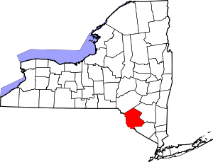 | |
| Villages | ||
| CDPs | ||
| Other hamlets | ||
| Indian reservation | ||
| Footnotes | ‡This populated place also has portions in another county or counties. | |