New Zealand State Highway 60
| ||||
|---|---|---|---|---|
 | ||||
| Route information | ||||
| Maintained by New Zealand Transport Agency | ||||
| Length: | 116.0 km (72.1 mi) | |||
| Major junctions | ||||
| South end: |
Main Road Hope/Gladstone Road | |||
| North end: | Collingwood | |||
| Location | ||||
| Primary destinations: | Motueka, Riwaka, Takaka | |||
| Highway system | ||||
| ||||

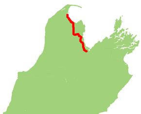
State Highway 60 is a state highway servicing the far northwest of the South Island of New Zealand. Running between the settlements of Richmond (south of Nelson) and Collingwood, it is 116 kilometres (72 mi) long and lies entirely within the Tasman District. It is the northernmost highway in the South Island and is a popular tourist route, servicing Motueka, Abel Tasman National Park, Golden Bay, and Farewell Spit.
Route
The highway starts at Richmond at a roundabout junction with SH 6 and proceeds in the northwesterly direction across the Waimea Plains. Near Mapua, the road deviates onto the Ruby Bay bypass (Mamaku Drive) and emerges on the shores of the Moutere Inlet adjacent to Tasman Village. The highway then passes along the edge of Motueka Estuary and through the major town of Motueka. Just past Riwaka, the road to Kaiteriteri and Abel Tasman National Park branches off to the right while SH 60 branches to the left. The highway then rises towards Takaka Hill and the notorious Eureka Bend (elevation 791 metres above sea level).[1] The highway then descends into the Takaka Valley and passes through the town of Takaka. The highway then hugs the coastline of Golden Bay before terminating at Collingwood.[2]
History
At first there was no road connecting the coastal areas about Bronte, Mapua and Tasman. Early settlers had roads from landing sites on Waimea Inlet and along ridges, and they avoided crossing the peripheral swampy valleys. When the Coastal Highway was constructed it was gravel and the Inland (Moutere) Highway was the main highway. At some point in about the 1970s, the coastal route became the main route. Until 2010, before the construction of the Ruby Bay bypass, SH 60 followed the coastline around Mapua.[3][4][5]
Gallery
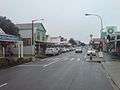 SH 60 as Commercial Street passing through Takaka
%2C_Skydiving.jpg) Aerial view of SH 60 passing through the southern section of Motueka
Aerial view of SH 60 passing through the southern section of Motueka
See also
References
| Wikimedia Commons has media related to State Highway 60 (New Zealand). |
- ↑ "Eureka Bend to be fixed". Nelson Mail. 17 January 2009. Retrieved 13 May 2016.
- ↑ State Highway 60 on Google Maps
- ↑ "Old meets new as bypass opens". Nelson Mail. 23 October 2010.
- ↑ "Ruby Bay Bypass Road Name Changes". Tasman District Council. Retrieved 12 May 2016.
- ↑ "Declaring a Section of State Highway-State Highway 60, Coastal Highway, Tasman District". NZ Gazette. 22 September 2011. Retrieved 5 July 2016.
External links
| National | ||
|---|---|---|
| North Island |
| |
| South Island | ||
| Former state highways | ||
| Touring routes |
| |