Nhandeara
| Nhandeara | |||
|---|---|---|---|
| Municipality | |||
| |||
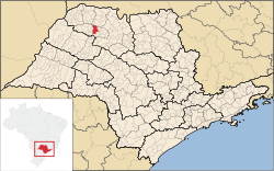 Location of Nhandeara | |||
 Nhandeara Location of Nhandeara | |||
| Coordinates: 20°41′40″S 50°02′19″W / 20.69444°S 50.03861°WCoordinates: 20°41′40″S 50°02′19″W / 20.69444°S 50.03861°W | |||
| Country |
| ||
| Region | Southeast | ||
| State |
| ||
| Mesoregion | São José do Rio Preto | ||
| Government | |||
| • Mayor | Ozínio Odilon da Silveira | ||
| Area | |||
| • Total | 435.8 km2 (168.3 sq mi) | ||
| Elevation | 475 m (1,558 ft) | ||
| Population (2010/IBGE) | |||
| • Total | 10,725 | ||
| • Density | 24.6/km2 (64/sq mi) | ||
| Time zone | UTC-3 (UTC-3) | ||
| • Summer (DST) | UTC-2 (UTC-2) | ||
| Postal Code | 15190-000 | ||
| Area code(s) | +55 17 | ||
| 'HDI (UNDP/2000) | 0.806 – high | ||
| Website | Prefecture of Nhandeara | ||

Nhandeara is a municipality in the state of São Paulo, Brazil. The city has a population of 10,725 inhabitants and an area of 435.8 km².[1]
Economy
The Tertiary sector is the economic basis of Nhandeara. Commerce, services and public administration corresponds to 62.3% of the city GDP. The Secondary sector is 19.4% of the GDP, and the Primary sector corresponds to 18.2%.[2]
Demographics
Health
- Hospitals: 1
Infrastructure
- Bank agencies: 4
- Industries: 67
- Commercial establishments: 279
- Services: 161
Transportation
References
- ↑ "Population at "Censo 2010"" (PDF) (in Portuguese). IBGE.gov.br. Retrieved 1 Jun 2012.
- ↑ "Municipal Profile at SEADE". SEADE.gov.br. Retrieved 2 Jun 2012.
This article is issued from Wikipedia - version of the 5/15/2016. The text is available under the Creative Commons Attribution/Share Alike but additional terms may apply for the media files.