Nil-Saint-Vincent-Saint-Martin
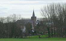
Nil-Saint-Vincent-Saint-Martin is a former municipality in the province of Walloon Brabant, Belgium. In 1976 it became part of the municipality of Walhain.[1]
The villages of Nil-Saint-Vincent and Nil-Saint-Martin were merged in 1812.[2] 'Nil' is the name of a small river, along whose valley the various areas of settlement (Nil-Pierreux, Nil-Saint-Vincent, Nil-Saint-Martin) lie.

Landmarks
Nil-Saint-Vincent-Saint-Martin has several notable landmarks.
The Tiège windmill
The Tiège windmill was built in 1834 by the Thienpont family. It was used until June 23, 1946[3] and today is a listed building (monument classé).
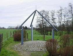
The centre of Belgium
The Institut Géographique National, the Belgian national cartographical service, calculated that the geographical centre of Belgium lay in Nil-Saint-Vincent.[4] The architect Bernard Defrenne built a monument for this location, which was inaugurated on August 22, 1998.[4] It is located at coordinates 50°38′28″N 4°40′05″E / 50.64111°N 4.66806°E.[5]
References
- ↑ "Belgian Civic Heraldry - Walhain". Retrieved 2007-03-09.
- ↑ "Histoire de Nil-Saint-Vincent" (in French). Municipality of Walhain. Archived from the original on 2007-03-19. Retrieved 2007-03-09.
- ↑ Sign seen next to the windmill (See Moulin Du Tiège sign photo)
- 1 2 "Centre géographique - Le Site" (in French). Municipality of Walhain. Archived from the original on 2007-05-14. Retrieved 2007-03-09.
- ↑ "Center Cache". Retrieved 2007-03-09.
External links
-
 Media related to Nil-Saint-Vincent-Saint-Martin at Wikimedia Commons
Coordinates: 50°38′21″N 4°40′21″E / 50.639037°N 4.67258°E