Nindooinbah, Queensland
| Nindooinbah Queensland | |||||||||||||
|---|---|---|---|---|---|---|---|---|---|---|---|---|---|
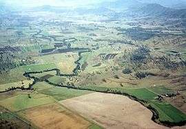 Cainbable Creek meets the Albert River | |||||||||||||
 Nindooinbah | |||||||||||||
| Coordinates | 28°02′52″S 153°03′04″E / 28.0477°S 153.051°ECoordinates: 28°02′52″S 153°03′04″E / 28.0477°S 153.051°E | ||||||||||||
| Postcode(s) | 4285 | ||||||||||||
| LGA(s) | Scenic Rim Region | ||||||||||||
| State electorate(s) | Beaudesert | ||||||||||||
| Federal Division(s) | Wright | ||||||||||||
| |||||||||||||
Nindooinbah is a rural community in the Scenic Rim Region, Queensland, Australia.[1] Nindooinbah occupies a part of the upper Albert River valley where Cainbable Creek joins the river. The Albert River also marks portions of both the eastern and western borders. In the east of the locality the slopes of Mount Witheren reach more than 550 m above sea level. Farming dominates the lower central areas along two main roads aligned in a north/south direction.
History
The name Nindooinbah is derived from the name of a pastoral run of 1842/3, based on Aboriginal words: nguin meaning charcoal / cinders, doan meaning black' and ba meaning place, indicating the place of the remains of a fire.[1]
Heritage listings
Nindooinbah has a number of heritage-listed sites, including:
- Nindooinbah Connection Road: Nindooinbah Homestead[2]
References
- 1 2 "Nindooinbah (entry 45176)". Queensland Place Names. Queensland Government. Retrieved 13 September 2015.
- ↑ "Nindooinbah Homestead (entry 600027)". Queensland Heritage Register. Queensland Heritage Council. Retrieved 12 July 2013.
External links
![]() Media related to Nindooinbah, Queensland at Wikimedia Commons
Media related to Nindooinbah, Queensland at Wikimedia Commons