Nippes, Cologne
| Nippes | |
|---|---|
| 5th District of Cologne | |
|
| |
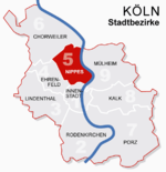 Location of Nippes shown in red | |
| Country | Germany |
| Federal state | North Rhine-Westphalia |
| City | Cologne |
| Area | |
| • Total | 31.8 km2 (12.3 sq mi) |
| Population (December 2008) | |
| • Total | 110,092 |
| • Density | 3,462/km2 (8,970/sq mi) |

Nippes (German: Köln-Nippes [ˈkʰœlnipʰəs], Colognian: Neppes [ˈneˑpəs]) is the Fifth city district (Stadtbezirk) of Cologne, Germany. Nippes was merged into the city of Cologne in 1888, the district was formed in 1975. In Niehl, the North-eastern part of the district lies the large Ford Europe production plant.
The district borders with the Cologne districts of Chorweiler to the North, Mülheim to the East, Innenstadt to the South and Ehrenfeld to the South-West.
Subdivisions
Nippes consists of seven Stadtteile (city parts):
| # | City part | Population (2009) | Area (km²) | Pop. per km² | map |
|---|---|---|---|---|---|
| 501 | Nippes | 33,948 | 2,99 | 11,351 | 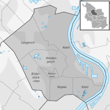 |
| 502 | Mauenheim | 5,641 | 0,49 | 11,543 | |
| 503 | Riehl | 11,173 | 2,39 | 4,674 | |
| 504 | Niehl | 18,249 | 12,1 | 1,512 | |
| 505 | Weidenpesch | 13,566 | 3,91 | 3,469 | |
| 506 | Longerich | 13,536 | 6,14 | 2,203 | |
| 507 | Bilderstöckchen | 15,028 | 3,76 | 3,992 | |
| source: Die Kölner Stadtteile in Zahlen 2010 (German) | |||||
Transportation
Nippes is served by numerous railway stations and highway. Train station include Köln-Nippes, Köln Geldernstraße/Parkgürtel and Köln-Longerich, as well as numerous light rail stations of Cologne Stadtbahn line 12, 15, 16 and 18. The Bundesautobahn 57 connects Nippes with the Cologne Beltway.
Rhine bridges
Notable people
- Fritz Schramma (born 1947), mayor of Cologne from 2000 until 2009
- Gaby Köster (born 1961), actress and cabaretist
External links
| Wikimedia Commons has media related to Köln-Nippes. |
- Official webpage of the district (German)
| ||
Coordinates: 50°57′52″N 6°57′30″E / 50.9644°N 6.95833°E