North Carolina Highway 104
| ||||
|---|---|---|---|---|
| Riverside Drive | ||||
 | ||||
| Route information | ||||
| Maintained by NCDOT | ||||
| Length: | 4.8 mi[1] (7.7 km) | |||
| Existed: | 1940 – present | |||
| Major junctions | ||||
| South end: |
| |||
| North end: |
| |||
| Location | ||||
| Counties: | Surry | |||
| Highway system | ||||
| ||||

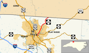
North Carolina Highway 104 (NC 104) is a five-mile-long (8.0 km) North Carolina state highway. It connects northeast Surry County with downtown Mount Airy following Riverside Drive.
Route description
NC 104 begins at NC 103 in downtown Mount Airy (also known as Pine Street) and immediately heads north along Riverside Drive. The road passes Riverside Park very close to the southern terminus of the route. NC 104 exits Mount Airy and crosses the Ararat River (after closely paralleling it for the rest of its route) before ending at the Virginia border. The road continues northeast as Ararat Highway (State Route 773) towards Ararat, Virginia.[1]
History
NC 104 appears on the 1924 North Carolina State Map running from NC 10 in Garden City to NC 69 in Micaville. In 1925 NC 104 was truncated to the current U.S. Route 70 (US 70)-NC 80 junction. In 1930 the road was extended along US 19E then was routed to Loafers Glory. In 1940 NC 104 was renumbered as NC 80.
In 1940 NC 104 was re-introduced as a renumbering of NC 800. The route ran from US 52 to Virginia State Route 104 (now secondary SR 773) at the state border. Between 1954 and 1957 NC 104 was rerouted to its current southern terminus at NC 103.[2]
Junction list
The entire route is in Surry County.
| Location | mi[1] | km | Destinations | Notes | |
|---|---|---|---|---|---|
| Mount Airy | 0.0 | 0.0 | |||
| | 4.8 | 7.7 | Virginia state line | ||
| 1.000 mi = 1.609 km; 1.000 km = 0.621 mi | |||||
References
- 1 2 3 Google (March 11, 2016). "North Carolina Highway 104" (Map). Google Maps. Google. Retrieved March 11, 2016.
- ↑ http://www.vahighways.com/ncannex/route-log/nc104.html