North Carolina Highway 141
| ||||
|---|---|---|---|---|
 | ||||
| Route information | ||||
| Maintained by NCDOT | ||||
| Length: | 8.7 mi[1] (14.0 km) | |||
| Existed: | 1983 – present | |||
| Major junctions | ||||
| South end: |
| |||
| North end: |
| |||
| Location | ||||
| Counties: | Cherokee | |||
| Highway system | ||||
| ||||

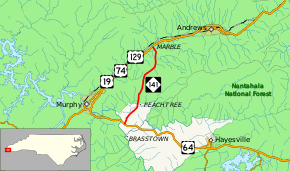
North Carolina Highway 141 (NC 141) is a primary state highway in the state of North Carolina. It serves to connect the Peachtree community, located in the Valley River Mountains, with Marble and Murphy.
Route description
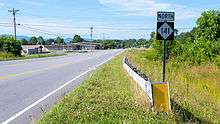
The entire 8.7-mile (14.0 km) length of NC 141 is contained within Cherokee County. The southern terminus of the highway is at U.S. Route 64 (US 64) between Murphy and Hayesville (north of the community of Brasstown). Its northern terminus is at US 19/US 129/US 74 and Marble Road in Marble.
The route serves as an important transportation link across Cherokee County providing access for traffic from Marble and Andrews to the Peachtree community where Murphy Medical Center, the area's only major hospital, and Tri-County Community College are located. Conversely, the reverse route provides quick access from these areas, as well as Hayesville to the Andrews-Murphy Airport.
The route passes through several small communities along the way from Marble to Peachtree, including Vengeance Creek and Rowland Hill.
History
The first NC 141 was established in 1954 as a new primary routing, from US 74/US 76 to NC 53, near Atkinson. In 1974, NC 141 was replaced by NC 11.[2]
The second and current NC 141 was established around 1983 as a new primary routing from US 64 to US 19 and US 129. In 2010, NC 141 was extended south over a former section of US 64 and ends at a new terminus with US 64.[3]
Junction list
The entire route is in Cherokee County.
| Location | mi[1] | km | Destinations | Notes | |
|---|---|---|---|---|---|
| | 0.0 | 0.0 | |||
| Marble | 8.7 | 14.0 | |||
| 1.000 mi = 1.609 km; 1.000 km = 0.621 mi | |||||
References
- 1 2 Google (June 22, 2014). "North Carolina Highway 141" (Map). Google Maps. Google. Retrieved June 22, 2014.
- ↑ "Route Change (1974-09-26)" (PDF). North Carolina Department of Transportation. September 29, 1974. Retrieved July 11, 2014.
- ↑ "Route Change (2010-02-04)" (PDF). North Carolina Department of Transportation. February 4, 2010. Retrieved July 11, 2014.
External links
-
 Media related to North Carolina Highway 141 at Wikimedia Commons
 - NCRoads.com: N.C. 141