North Carolina Highway 343
| ||||
|---|---|---|---|---|
 | ||||
| Route information | ||||
| Maintained by NCDOT | ||||
| Length: | 25.5 mi[1] (41.0 km) | |||
| Existed: | 1930 – present | |||
| Major junctions | ||||
| South end: | Wharf Road in Old Trap | |||
|
| ||||
| North end: |
| |||
| Location | ||||
| Counties: | Camden | |||
| Highway system | ||||
| ||||

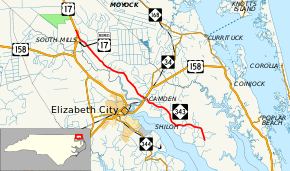
North Carolina Highway 343 (NC 343) is a primary state highway in the state of North Carolina. It serves to connect the county seat of Camden with both the north and south ends of Camden County.
Route description
NC 343 begins at the intersection of Wharf Road (SR 1104) and Texas Road (SR 1100) in Old Trap. Going in an northeasterly direction and parallel to Pasquotank River to its west, it goes through the communities of Alder Branch, Shiloh and Taylors Beach. Passing through Camden, it links with U.S. Route 158 (US 158). Continuing northeasterly, it continues through the communities of Spences Corner, Lambs Corner, Burnt Mills and finally South Mills, where it joins US 17 Business (US 17 Bus.). Routed alongside the Great Dismal Swamp Canal, it ends at US 17 just north of South Mills.[1]
The northern section, between Camden and South Mills, is frequently used in the summer months as an alternative route to and from the Outer Banks, from travelers from the Hampton Roads metro area of Virginia.
Junction list
The entire route is in Camden County.
| Location | mi[1] | km | Destinations | Notes | |
|---|---|---|---|---|---|
| Old Trap | 0.0 | 0.0 | Wharf Road / Texas Road | ||
| Camden | 11.6 | 18.7 | |||
| South Mills | 23.9 | 38.5 | South end of US 17 Bus. overlap | ||
| | 25.5 | 41.0 | North end of US 17 Bus. overlap | ||
| 1.000 mi = 1.609 km; 1.000 km = 0.621 mi | |||||
See also
- North Carolina Bicycle Route 4 - Concurrent with NC 343 from US 158 to Scotland Road in Camden
References
- 1 2 3 Google (June 6, 2014). "North Carolina Highway 343" (Map). Google Maps. Google. Retrieved June 6, 2014.
External links
-
 Media related to North Carolina Highway 343 at Wikimedia Commons
 - NCRoads.com: N.C. 343