U.S. Route 17 in North Carolina
| ||||
|---|---|---|---|---|
|
Route of US 17 in red | ||||
| Route information | ||||
| Maintained by NCDOT | ||||
| Length: | 286.0 mi[1] (460.3 km) | |||
| Existed: | 1927 – present | |||
| Major junctions | ||||
| South end: |
| |||
|
| ||||
| North end: |
| |||
| Highway system | ||||
| ||||

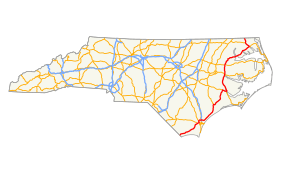
In the U.S. state of North Carolina U.S. Route 17 (US 17) is a north–south highway that is known as the Coastal Highway in the southeastern half of the state and the Ocean Highway in other areas. The route enters the state from South Carolina near Calabash, and leaves in the vicinity of the Great Dismal Swamp National Wildlife Refuge in Virginia. Between the US 64 freeway and the Virginia state line, US 17 is a four-lane divided highway with speed limits varying between 45 miles per hour (72 km/h) and 70 miles per hour (110 km/h).
Route description
US 17 enters Brunswick County, North Carolina in Carolina Shores amid a variety of golf course communities. Carolina Shores was part of Calabash until 1998.
In Wilmington, US 17 (here concurrent with Interstate 140) crosses the Northeast Cape Fear River between New Hanover County and Brunswick County over the Dan Cameron Bridge. North of Holly Ridge US 17 begins to move further away from the Atlantic Coast. Then, it bypasses Jacksonville along with NC 24. Between New Bern and James City, US 17 (concurrent with US 70 and NC 55) crosses the Trent River by way of the Freedom Memorial Bridge. Farther east, between James City and Bridgeton, US 17, still concurrent with NC 55, crosses the Neuse River over the Neuse River Bridge. Traffic going north on US-17 when using US-70's concurrency can bypass New Bern altogether via NC 43, ironically both the west end of US-17's concurrency on US-70 and NC 43's southern terminus both, respectively have a north and south protrusion of unused highway since full cloverleaf junctions were scrapped in the area.
In Washington, US 17 crosses the Pamlico River over the Pamlico-Tar River Bridge and intersects with NC 32 and US 264. Farther along in Bear Grass, US 17 joins a concurrency with a limited-access portion of US 13-64, although US 64 moves east before US 13-17 reaches Williamston, where the limited-access segment ends. US 13-17 uses the Roanoke River Bridge to cross the Roanoke River, then before US 13 moves onto the interchange with North King Street it crosses the Cashie River Bridge over the Cashie River at Windsor. At the Bertie County-Chowan County line, US 17 traverses the Chowan River from Edenhouse to Edenton. East of Edenton, US 17 shares a concurrency with NC 37 until they reach Hertford where it branches off to the northwest onto US BUS 17. US 17 crosses the Perquimans River via the Perquimans River Bridge. Between Perquimans County and Pasquotank County, US 17 crosses the Little River over the Little River Bridge. A bypass route splits off to the northwest as US 17 (Mainline) continues into Elizabeth City as Hughes Boulevard, picking up concurrency with US 158 until US 158 splits off to the west at Morgan's Corner. US 17 crosses the Pasquotank River between Morgan's Corner in Pasquotank County and South Mills in Camden County, before entering Virginia adjacent to the Great Dismal Swamp National Wildlife Refuge.
History
US 17 was established in 1927, traversing from South Carolina, near Fair Bluff, to Virginia, near South Mills. Its routing was placed along the following state highways: NC 202, from the South Carolina state line to Chadbourn; NC 20, from Chadbourn to Wilmington; NC 30, from Wilmington to Windsor; NC 342, from Windsor to Elizabeth City; NC 34, from Elizabeth City to Morgans Corner; and NC 341, from Morgans Corner to the Virginia state line.[2]
Interstate proposals
As a major north-south corridor through the coastal area, US 17 has been the target of various interstate proposals over the years. The earliest known proposal was in 1964, with a proposal supported by Governor Terry Sanford, was to build a new interstate from Fayetteville to Norfolk, Virginia, via US 13 and US 17. Named Interstate 13, it received support from various local officials; but was not supported by the North Carolina Highway Commission, which ended discussions.[3]
During the mid-1990s through mid-2000s, Interstate 99 was proposed between Charleston, South Carolina and Wilmington, Delaware, completely overlapping all of US 17 in North Carolina. In 2006, the Virginia Department of Transportation (VDOT) completed a study on the feasibility of the interstate and concluded with the high cost and disinterest of other states, notably South Carolina, that it was not feasible and recommend to not pursue further.[4]
In 2012, NCDOT backed and presented a letter to the Federal Highway Administration (FHWA) requesting the establishment of a new high priority corridor between Raleigh and Norfolk, named Interstate 44 (or Interstate 50). This corridor follows US 64 and US 17, north of Williamston.[5] The following year, Interstate 495 was established east of Raleigh and was routed on part of this proposed route. In 2014, various supporters, including Governor Pat McCrory, Congressman G. K. Butterfield, NCDOT and the Regional Transportation Alliance (RTA), have made cases and written letters to federal officials in support of the new interstate corridor.[6][7][8] In 2016, AASHTO approved designation of I-87 along US 17 between Williamston and the Virginia state line.
North Carolina Highway 341
| |
|---|---|
| Location: | Morgans Corner, NC–VA state line |
| Length: | 10.4 mi[9] (16.7 km) |
| Existed: | 1921–1934 |
North Carolina Highway 341 (NC 341) was an original state highway that traversed from NC 34, in Morgans Corner, to South Mills. In 1923, it was extended north to the Virginia state line, meeting up with SR 40. In 1927, it was completely overlapped with US 17, which subsequently replaced it outright in 1934.[2]
Future
In Chowan County, the existing freeway section of US 17, which bypasses Edenton, will be fully upgraded to modern interstate standards. At a cost of $13 million, it will mainly focus on widening travel lanes and building shoulders; construction is planned to start in 2025.[10]
Junction list
| County | Location | mi[1] | km | Exit | Destinations | Notes |
|---|---|---|---|---|---|---|
| Brunswick | Carolina Shores | 0.0 | 0.0 | South Carolina state line | ||
| | Proposed interchange (unfunded)[11][12] | |||||
| Grissettown | 6.9 | 11.1 | ||||
| Shallotte | 11.9 | 19.2 | ||||
| 13.2 | 21.2 | |||||
| 16.0 | 25.7 | |||||
| Supply | 21.6 | 34.8 | ||||
| | 23.6 | 38.0 | Superstreet intersection | |||
| | 28.6 | 46.0 | ||||
| Bolivia | 30.5 | 49.1 | ||||
| Winnabow | 35.0 | 56.3 | South end of NC 87 overlap | |||
| | 38.3 | 61.6 | North end of NC 87 overlap, superstreet intersection | |||
| | 39.2 | 63.1 | 39 | |||
| Leland | 44.0 | 70.8 | West end of US 74/US 76 overlap | |||
| 45.0 | 72.4 | West end of NC 133 overlap | ||||
| 47.0 | 75.6 | East end of US 76 and south end of US 421 overlap | ||||
| New Hanover | | 48.5 | 78.1 | East end of US 74 and north end of NC 133 overlap | ||
| | 51.3 | 82.6 | 14 | West end of I–140/NC 140 and north end of US 421 overlap | ||
| NE Cape Fear River | 52.2 | 84.0 | Dan Cameron Bridge | |||
| | 55.0 | 88.5 | 17 | I-140 exit 17 | ||
| Murraysville | 58.0 | 93.3 | 20 A-B | A: B: | Signed as exits 20A (west) and 20B (east) East end of I-140 overlap | |
| Kirkland | 63.2 | 101.7 | East end of NC 140 overlap | |||
| Pender | Hampstead | 69.1 | 111.2 | West end of NC 210 overlap | ||
| | 77.7 | 125.0 | East end of NC 210 overlap | |||
| Onslow | Holly Ridge | 81.9 | 131.8 | |||
| Folkstone | 86.3 | 138.9 | ||||
| Dixon | 89.9 | 144.7 | ||||
| Jacksonville | 101.2 | 162.9 | ||||
| 101.6 | 163.5 | Wes end of NC 24 overlap; Southbound access to US 17 Bus northbound | ||||
| 104.6 | 168.3 | Montford Point Road | Northbound exit and southbound entrance | |||
| 105.0 | 169.0 | East end of NC 24 overlap | ||||
| 106.4 | 171.2 | Huff Drive | ||||
| 107.2 | 172.5 | Northern terminus of US-Bus 17 | ||||
| Jones | Maysville | 120.5 | 193.9 | South end of NC 58 overlap | ||
| Pollocksville | 127.5 | 205.2 | North end of NC 58 overlap | |||
| | 132.7 | 213.6 | ||||
| Craven | | 132.8 | 213.7 | 147 | Signed as exits 147A (east) and 147B (west); US 17 exits 147A | |
| | 139.1 | 223.9 | 412 | |||
| New Bern | 141.3 | 227.4 | Glenburnie Road | To Craven Community College | ||
| 142.3 | 229.0 | |||||
| 143.9 | 231.6 | 416 | West end of NC 55 overlap | |||
| 145.1 | 233.5 | 417 | Signed as exits 417A (Front) and 417B (west); east end of US 70 overlap | |||
| Bridgeton | 147.8 | 237.9 | East end of NC 55 overlap | |||
| Emul | 158.2 | 254.6 | South end of NC 43 overlap | |||
| Vanceboro | 161.7 | 260.2 | North end of NC 43 overlap | |||
| 165.1 | 265.7 | |||||
| Beaufort | | 172.0 | 276.8 | Eastern terminus of NC 102 | ||
| | 177.1 | 285.0 | Superstreet intersection | |||
| Chocowinity | 177.9 | 286.3 | 176 | |||
| Washington | 181.9 | 292.7 | 180 | |||
| 182.7 | 294.0 | Superstreet intersection | ||||
| Old Ford | 187.2 | 301.3 | ||||
| Martin | Williamston | 200.5 | 322.7 | 514 | South end of US 13 and west end of US 64 overlap | |
| 202.0 | 325.1 | 515 | East end of US 64 overlap | |||
| 202.2 | 325.4 | |||||
| 203.4 | 327.3 | |||||
| Bertie | Windsor | 214.6 | 345.4 | North end of US 13 and south end of US 13 Bus overlap | ||
| 214.7 | 345.5 | North end of US 13 Bus overlap | ||||
| 215.6 | 347.0 | West end of NC 308 overlap | ||||
| 216.8 | 348.9 | East end of NC 308 overlap | ||||
| | 222.5 | 358.1 | ||||
| Midway | 225.9 | 363.6 | ||||
| Chowan | | 232.9 | 374.8 | 224 | ||
| Edenton | 235.0 | 378.2 | 226 | Dr. Martin Luther King Jr Avenue | ||
| 236.1 | 380.0 | 227 | ||||
| 237.2 | 381.7 | 228 | Paradise Road | |||
| | 238.7 | 384.2 | 230 | |||
| Perquimans | | 240.9 | 387.7 | South end of NC 37 overlap | ||
| Hertford | 246.8 | 397.2 | ||||
| Winfall | 250.0 | 402.3 | North end of NC 37 overlap | |||
| Pasquotank | Rabbit Corner | 257.9 | 415.0 | 254 | Okisko Road | |
| | 258.5 | 416.0 | 255 | |||
| Elizabeth City | 263.2 | 423.6 | ||||
| 263.6 | 424.2 | |||||
| 264.7 | 426.0 | East end of US 158 overlap | ||||
| 265.6 | 427.4 | |||||
| | 272.9 | 439.2 | 264 | |||
| Morgans Corner | 276.0 | 444.2 | West end of US 158 overlap | |||
| Camden | South Mills | 277.4 | 446.4 | |||
| | 279.8 | 450.3 | ||||
| | 286.0 | 460.3 | Virginia state line | |||
1.000 mi = 1.609 km; 1.000 km = 0.621 mi
| ||||||
Bannered routes
There are numerous existing and former bannered routes of US 17 within the state of North Carolina.
See also
- North Carolina Bicycle Route 3 - Concurrent with US 17 at multiple locations
- North Carolina Bicycle Route 5 - Concurrent with US 17 on its NC 133 concurrency
References
- 1 2 Google (May 22, 2014). "U.S. Route 17 in North Carolina" (Map). Google Maps. Google. Retrieved May 22, 2014.
- 1 2 State Highway System of North Carolina (PDF) (Map). Cartography by NCDOT. North Carolina Department of Transportation. 1930. Retrieved March 28, 2015.
- ↑ "Sanford Backs New Road Plan". Star-News. Wilmington, NC. April 17, 1964. Retrieved March 28, 2015.
- ↑ Homer, Pierce R. (November 2006). "Construction of I-99: Appropriation Act Item 427 H. (Special Session I, 2006)" (PDF). Virginia Department of Transportation. Retrieved August 10, 2013.
- ↑ Gibson, Terry R. (November 27, 2012). "Designation of I-44" (PDF) (Letter). Letter to John F. Sullivan III. Raleigh, NC: North Carolina Department of Transportation. Retrieved May 15, 2014.
- ↑ Tata, Anthony J. (June 11, 2014). "Route to Opportunity and Development Act (ROAD Act_" (PDF) (Letter). Letter to G.K. Butterfield. North Carolina Department of Transportation. Retrieved September 4, 2014.
- ↑ "Future Interstate Designation: Raleigh, NC to Norfolk, VA" (PDF). North Carolina Department of Transportation. June 11, 2014. Retrieved September 4, 2014 – via Regional Transportation Alliance.
- ↑ "Interstate 495 to Rocky Mount—Future I-44 to Hampton Roads". Raleigh, NC: Regional Transportation Alliance. December 14, 2013. Retrieved February 16, 2014.
- ↑ Google (March 28, 2015). "North Carolina Highway 341" (Map). Google Maps. Google. Retrieved March 28, 2015.
- ↑ "SPOT ID: H141869" (PDF). North Carolina Department of Transportation. September 22, 2014. Retrieved March 28, 2015.
- ↑ Staff. "I-74 Feasibility Study". North Carolina Department of Transportation. Retrieved May 22, 2014.
- ↑ I-74 Feasibility Map (PDF) (Map). North Carolina Department of Transportation. Retrieved May 22, 2014.
External links
-
 Media related to U.S. Route 17 in North Carolina at Wikimedia Commons
 - NCRoads.com: U.S. 17
- NCRoads.com: U.S. 17-A
- NCRoads.com: U.S. 17 Business
- North Carolina @ AARoads - U.S. Highway 17
| Previous state: South Carolina |
North Carolina | Next state: Virginia |