North Concho River
| North Concho River | |
| River | |
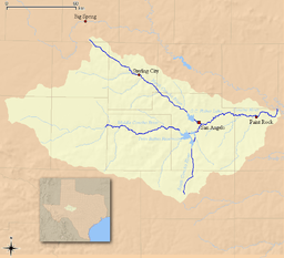 Map of the Concho River and its tributaries | |
| Country | United States |
|---|---|
| State | Texas |
| Source | |
| - location | Howard County, Texas |
| - coordinates | 32°06′58″N 101°27′12″W / 32.11611°N 101.45333°W |
| Mouth | Concho River |
| - location | near Goodfellow Air Force Base, Tom Green County, Texas |
| - elevation | 1,798 ft (548 m) |
| - coordinates | 31°27′16″N 100°24′59″W / 31.45444°N 100.41639°WCoordinates: 31°27′16″N 100°24′59″W / 31.45444°N 100.41639°W |
| Length | 88 mi (142 km) |
| [1][2] | |
The North Concho River is a river in western-central Texas and one of three tributaries of the Concho River. The river is 88 miles (142 km) long. The other two tributaries are the Middle Concho and South Concho Rivers. The Concho River flows into the Colorado River (in Texas, not to be confused with the Colorado that flows through Arizona and Nevada).
Course
The North Concho River headwaters start in Glasscock Co. and flow toward Sterling City in Sterling County, then Water Valley, Carlsbad, and Grape Creek in Tom Green Co., and into O.C. Fisher Reservoir (formerly San Angelo Lake)[3] Water released from the lake flows under 29th St. and meanders through northwest and downtown San Angelo, until it merges with the South Concho to form the main Concho at Bell St. Since 1980, $2 million have been spent to improve the city portion of the river, and plans are made to spend $8 million more.[4]
See also
References
- ↑ U.S. Geological Survey Geographic Names Information System: North Concho River. Retrieved on 2008-05-30.
- ↑ Concho River. Handbook of Texas Online. Retrieved on 2008-05-30
- ↑ .http://corpslakes.usace.army.mil/visitors/projects.cfm?Id=M216090
- ↑ http://www.gosanangelo.com/news/2008/dec/21/source-of-economic-life/