Colorado River (Texas)
| Colorado River | |
| Texas | |
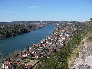 The Colorado River in Austin, as seen from Mount Bonnell. | |
| Country | United States |
|---|---|
| State | Texas |
| Source | |
| - location | Dawson County |
| - elevation | 3,280 ft (1,000 m) [1] |
| - coordinates | 32°40′47″N 101°43′51″W / 32.67972°N 101.73083°W [2] |
| Mouth | Matagorda Bay |
| - location | Gulf of Mexico, at Matagorda County, Texas |
| - elevation | 0 ft (0 m) [1] |
| - coordinates | 28°35′41″N 95°58′59″W / 28.59472°N 95.98306°WCoordinates: 28°35′41″N 95°58′59″W / 28.59472°N 95.98306°W [2] |
| Length | 862 mi (1,387 km) |
| Basin | 39,900 sq mi (103,341 km2) [3] |
| Discharge | for Bay City |
| - average | 2,609 cu ft/s (74 m3/s) |
| - max | 84,100 cu ft/s (2,381 m3/s) |
| - min | 0 cu ft/s (0 m3/s) |
 Map of the Colorado River and associated watershed
| |
The Colorado River is an 862-mile (1,387 km) long river[4] in the U.S. state of Texas. It is the 18th longest river in the United States[4] and the longest river with both its source and its mouth within Texas.[3]
Its drainage basin and some of its usually dry tributaries extend into New Mexico. It flows generally southeast from Dawson County through Marble Falls, Austin, Bastrop, Smithville, La Grange, Columbus, Wharton, and Bay City before emptying into the Gulf of Mexico at Matagorda Bay.[3]
Course
The Colorado River originates south of Lubbock, on Llano Estacado, near Lamesa. It flows generally southeast, out of Llano Estacado and through the Texas Hill Country, through several reservoirs including Lake J.B. Thomas, E.V. Spence Reservoir, and Lake O.H. Ivie. The river flows through several more reservoirs before reaching Austin, including Lake Buchanan, Inks Lake, Lake Lyndon B. Johnson, commonly referred to as Lake LBJ and Lake Travis. The Llano River joins the Colorado at Lake LBJ near Kingsland. The Pedernales River joins the Colorado at Lake Travis near Briarcliff. After passing through Austin, the Colorado River continues flowing southeast until emptying into Matagorda Bay on the Gulf of Mexico, near Matagorda. The Texas waterway is not connected to, nor part of, the longer and more well-known Colorado River that originates in Colorado, flows through Utah and Nevada, created the Grand Canyon and Lake Mead, and marks the entire length of the state line separating Arizona and California.
History
The Colorado River, which means "red"[5] or "reddish" river in Spanish,[6] was frequently confused by Spanish explorers with the Brazos River to the north.[3] The European discoverer of these two neighboring rivers called the present Colorado River the Brazos de Dios, and called the present Brazos the Colorado River, and later the names were reversed.[6]
The upper Colorado River was controlled by Comanches from the early 18th century to the late 19th century. In 1757, Spanish Texas attempted to establish an outlying Catholic mission on the San Saba River, near its confluence with the Colorado River. Nearly defenseless and viewed by the Comanche tribe as a territorial invasion, the mission was sacked in 1758 by about 2,000 Comanches and their allies. The Comanche were not effectively challenged on the upper Colorado River for nearly a century.[7]
River modifications
The river is an important source of water for farming, cities, and electrical power production. Major man-made reservoirs on the river include Lake Buchanan, Inks Lake, Lake LBJ, Lake Marble Falls, Lake Travis, Lake Austin, and Lady Bird Lake in Austin. Collectively, these lakes are known as the Highland Lakes. In addition to power plants operating on each of the major lakes, waters of the Colorado are used for cooling the South Texas Nuclear Project, near Bay City. The Colorado River Municipal Water District owns and operates three reservoirs upstream of the Highland Lakes, Lake J. B. Thomas near Snyder, E.V. Spence Reservoir near Robert Lee, and O. H. Ivie Reservoir near Ballinger.
Flood control and use of the Colorado River is managed by two agencies established by the Texas Legislature, the Upper Colorado River Authority, and the Lower Colorado River Authority. There are 11 major reservoirs along the Colorado River.[8]
Major tributaries
The Colorado River is joined by five significant tributaries: Concho River, Pecan Bayou, Llano River, San Saba River and Pedernales River. Beals Creek is also a tributary fed by arroyos such as Sulphur Springs Draw, McKenzie, Seminole, Monument, Mustang, Midland, and Johnson Draws.[9]
Gallery
-
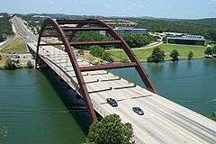
Pennybacker Bridge crossing the Lake Austin portion of the Colorado River.
-
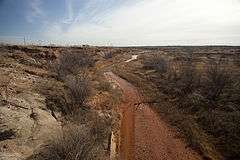
Colorado River 5 miles (8 km) from its source along the Caprock Escarpment, border of Dawson and Borden County, Texas.
-
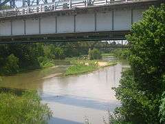
Colorado River under the Regency Suspension Bridge on the border of Mills and San Saba counties.
-
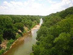
Scenic view of Colorado River meandering under a bridge overpass under State Highway 60 in Wharton.
-

Scene on the Colorado River, Austin, Texas (postcard, circa 1907)
-

Historical marker on US 90A between Eagle Lake and Altair explains the difficulty of navigating the lower Colorado River in the 1800s.
-
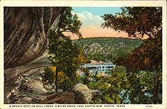
Old postcard of Bull Creek in Austin
-
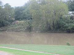
Colorado River east of Columbus, Texas
-

Green space at Beason's Park along the river in Columbus, Texas
See also
- List of crossings of the Colorado River
- List of tributaries of the Colorado River (Texas)
- Matagorda Bay — river's mouth
- Texas Hill Country
- List of rivers of Texas
Notes
- 1 2 Google Earth elevation for GNIS coordinates.
- 1 2 U.S. Geological Survey Geographic Names Information System: Colorado River
- 1 2 3 4 Clay, Comer; Kleiner, Diana J. (1999-02-15). "Colorado River". The Handbook of Texas Online. The General Libraries at the University of Texas at Austin and the Texas State Historical Association. Retrieved 2006-07-22.
- 1 2 Kammerer, J.C. (1987). "Largest Rivers in the United States". United States Geological Survey. Retrieved 2006-07-15.
- ↑ http://www.wordreference.com/es/en/translation.asp?spen=Colorado
- 1 2
 Ripley, George; Dana, Charles A., eds. (1879). "Colorado, a river of Texas". The American Cyclopædia.
- ↑ Hämäläinen, Pekka (2008). The Comanche Empire. Yale University Press. pp. 58–60. ISBN 978-0-300-12654-9. Online at Google Books
- ↑ "River Basin Map of Texas" (JPEG). Bureau of Economic Geology, University of Texas at Austin. 1996. Retrieved 2006-07-15.
- ↑ Rand McNally and Company. The road atlas, large scale '07 (Map). pp. 199-200. ISBN 9780528958342
External links
| Wikimedia Commons has media related to Colorado River (Texas). |
| Wikisource has original text related to this article: |
- Colorado River from the Handbook of Texas Online
- Map of Texas's Colorado River
- Upper Colorado River Authority
- Lower Colorado River Authority
