North Dagon Township
| North Dagon ဒဂုံမြို့သစ်မြောက်ပိုင်း မြို့နယ် | |
|---|---|
| Yangon | |
| North Dagon | |
 North Dagon | |
| Coordinates: 16°53′0″N 96°10′0″E / 16.88333°N 96.16667°ECoordinates: 16°53′0″N 96°10′0″E / 16.88333°N 96.16667°E | |
| Country | Myanmar |
| Division | Yangon |
| City | Yangon |
| Town | North Dagon |
| Settled | 1989[1] |
| Area | |
| • Total | 26.28 km2 (10.145 sq mi) |
| Population (2000)[2] | |
| • Total | 81,000 |
| • Density | 3,100/km2 (8,000/sq mi) |
| Time zone | MST (UTC6:30) |
| Postal codes | 11421, 11422 |
| Area code(s) | 1 (mobile: 80, 99) |
| YCDC[2] | |
North Dagon Township (also North Dagon Myothit; Burmese: ဒဂုံမြို့သစ်မြောက်ပိုင်း မြို့နယ် [dəɡòʊɴ mjo̰ðɪʔ mjaʊʔpáɪɴ mjo̰nɛ̀]) is located in the eastern part of Yangon, Myanmar. The township comprises 25 wards, and shares borders with East Dagon Township in the north and east, South Okkalapa township in the west, and South Dagon township in the south.[2] North Dagon is a relatively more developed area among the new satellite towns founded in 1989 by the military government. The realestate price is also considered highest among other new satellite townships.
The township has 24 primary schools, one middle school and four high schools.[2] Dagon University, the largest undergraduate university in the city, is located in the central part of the township.
North Dagon is connected to the mainland Yangon across the Pazundaung Creek by the Panglong Bridge and the Ba Htoo Bridge. Yangon Circular Railway runs a rail service between Dagon University and downtown Yangon.
References
- ↑ Kyaw Kyaw (2006). Frauke Krass; Hartmut Gaese; Mi Mi Kyi, eds. Megacity yangon: transformation processes and modern developments. Berlin: Lit Verlag. pp. 333–334. ISBN 3-8258-0042-3.
- 1 2 3 4 "North Dagon Township". Yangon City Development Committee. Archived from the original on 2 October 2011. Retrieved 2009-03-21.
Capital: Yangon | ||
| East Yangon District | 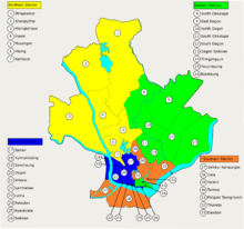 | |
| North Yangon District | ||
| South Yangon District | ||
| West Yangon District (Downtown) | ||
Capital: Yangon | ||
| East Yangon District |  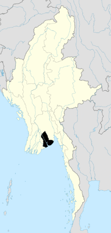 | |
| North Yangon District | ||
| South Yangon District | ||
| West Yangon District (Downtown) | ||
| Main cities and towns | ||
| States | ||
|---|---|---|
| Regions | ||
| Self-Administered Zones | ||
| Self-Administered Divisions | ||
| Union Territories | ||