Administrative divisions of Myanmar
| Administrative divisions of Myanmar | |
|---|---|
 | |
| Category | Unitary state |
| Location | Republic of the Union of Myanmar |
| Number | 7 divisions, 7 states, 1 Union Territory, 6 self-administered zones (as of 2015) |
| Populations | 286,627 (Kayah State) - 7,360,703 (Yangon Region) |
| Areas | 7,054 km2 (2,724 sq mi) (Naypyidaw Union Territory) - 155,801 km2 (60,155 sq mi) (Shan State) |
| Government | Government of Myanmar |
| Subdivisions |
District Township Ward and Village-tract Village |
| Administrative divisions of Myanmar |
|---|
| First-level |
| Second-level |
| Third-level |
| Fourth-level |
| Fifth-level |
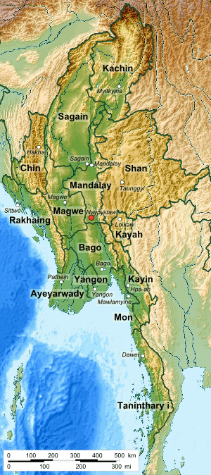
Myanmar is divided into twenty-one administrative subdivisions, which include:
| Type | Burmese name | No. of div. | |
|---|---|---|---|
| State | ပြည်နယ် | IPA: [pjìnɛ̀] | 7 |
| Region | တိုင်းဒေသကြီး | IPA: [táɪɴ dèθa̰ dʑí] | 7 |
| Union Territory | ပြည်တောင်စုနယ်မြေ | IPA: [pjìdàʊɴzṵnɛ̀mjè] | 1 |
| Self-Administered Zone | ကိုယ်ပိုင်အုပ်ချုပ်ခွင့်ရဒေသ | IPA: [kòbàɪɴ ʔoʊʔtɕʰoʊʔ kʰwɪ̰ɴja̰ dèθa̰] | 5 |
| Self-Administered Division | ကိုယ်ပိုင်အုပ်ချုပ်ခွင့်ရ တိုင်း | IPA: [kòbàɪɴ ʔoʊʔtɕʰoʊʔ kʰwɪ̰ɴja̰ táɪɴ] | 1 |
The regions were called divisions prior to August 2010,[1] and five of them are named after their capital city, the exceptions being Ayeyarwady Region and Tanintharyi Region. The regions can be described as ethnically predominantly Burman (Bamar), while the states, the zones and Wa Division are ethnic minority-dominant.
Yangon Region has the largest population and is the most densely populated. The smallest population is Kayah State. In terms of land area, Shan State is the largest and Yangon Region is the smallest.
States and divisions are divided into districts (ခရိုင်; kha yaing or khayaing, IPA: [kʰəjàɪɴ]). These districts consist of townships (မြို့နယ်; myo-ne, IPA: [mjo̰nɛ̀]) that include towns (မြို့; myo, IPA: [mjo̰]), wards (ရပ်ကွက်; yatkwet, IPA: [jaʔ kwɛʔ])) and village-tracts (ကျေးရွာအုပ်စု; kyayywa oksu, IPA: [tɕé jwà ʔoʊʔ sṵ]). Village-tracts are groups of adjacent villages (ကျေးရွာ; kyayywa, IPA: [tɕé jwà]).
Structural hierarchy
| Level | 1st | 2nd | 3rd | 4th | 5th |
|---|---|---|---|---|---|
| Division Type |
Union Territory (ပြည်တောင်စုနယ်မြေ) |
District (ခရိုင်) |
Township (မြို့နယ်) |
Ward (ရပ်ကွက်) |
- |
| Region (တိုင်းဒေသကြီး) State (ပြည်နယ်) |
- | ||||
| Village tract (ကျေးရွာအုပ်စု) |
Village (ကျေးရွာ) | ||||
| Self-Administered Division (ကိုယ်ပိုင်အုပ်ချုပ်ခွင့်ရတိုင်း) |
- | ||||
| Self-Administered Zone (ကိုယ်ပိုင်အုပ်ချုပ်ခွင့်ရဒေသ) |
- | ||||
Administrative regions
States, Regions, and Union Territories
| Flag | Name | Burmese | Capital | ISO[2] | Region | Population (2014) | Area (km²) | Type |
|---|---|---|---|---|---|---|---|---|
| |
Ayeyarwady Region | ဧရာဝတီတိုင်းဒေသကြီး | Pathein | MM-07 | Lower | 6,184,829[3] | 35,031.8 | Region |
 |
Bago Region | ပဲခူးတိုင်းဒေသကြီး | Bago | MM-02 | Lower | 4,867,373[3] | 39,402.3 | Region |
 |
Chin State | ချင်းပြည်နယ် | Hakha | MM-14 | West | 478,801[3] | 36,018.8 | State |
 |
Kachin State | ကချင်ပြည်နယ် | Myitkyina | MM-11 | North | 1,689,441[3] | 89,041.8 | State |
 |
Kayah State | ကယားပြည်နယ် | Loikaw | MM-12 | East | 286,627[3] | 11,731.5 | State |
| |
Kayin State | ကရင်ပြည်နယ် | Pa-an | MM-13 | South | 1,574,079[3] | 30,383 | State |
 |
Magway Region | မကွေးတိုင်းဒေသကြီး | Magwe | MM-03 | Central | 3,917,055[3] | 44,820.6 | Region |
 |
Mandalay Region | မန္တလေးတိုင်းဒေသကြီး | Mandalay | MM-04 | Central | 6,165,723[3] | 37,945.6 | Region |
 |
Mon State | မွန်ပြည်နယ် | Mawlamyaing | MM-15 | South | 2,054,393[3] | 12,296.6 | State |
 |
Rakhine State | ရခိုင်ပြည်နယ် | Sittwe | MM-16 | West | 3,188,807[3] | 36,778.0 | State |
| |
Shan State | ရှမ်းပြည်နယ် | Taunggyi | MM-17 | East | 5,824,432[3] | 155,801.3 | State |
 |
Sagaing Region | စစ်ကိုင်းတိုင်းဒေသကြီး | Sagaing | MM-01 | North | 5,325,347[3] | 93,704.8 | Region |
 |
Tanintharyi Region | တနင်္သာရီတိုင်းဒေသကြီး | Dawei | MM-05 | South | 1,408,401[3] | 44,344.9 | Region |
 |
Yangon Region | ရန်ကုန်တိုင်းဒေသကြီး | Yangon | MM-06 | Lower | 7,360,703[3] | 10,276.7 | Region |
 |
Naypyidaw Union Territory | နေပြည်တော် ပြည်ထောင်စုနယ်မြေ | Naypyidaw | MM-18 | Central | 1,160,242[3] | 7,054 | Union Territory |
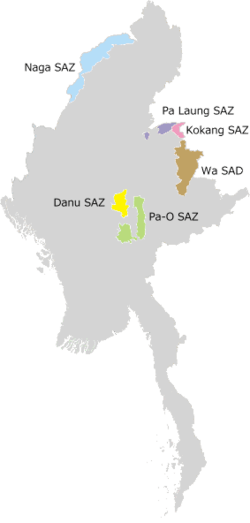
Self-Administered Zones and Self-Administered Divisions
| Name | Burmese | Capital | Region | Population | Area (km²) | Type |
|---|---|---|---|---|---|---|
| Danu Self-Administered Zone | ဓနုကိုယ်ပိုင်အုပ်ချုပ်ခွင့်ရဒေသ | Pindaya | East | Self-Administered Zone | ||
| Kokang Self-Administered Zone | ကိုးကန့်ကိုယ်ပိုင်အုပ်ချုပ်ခွင့်ရဒေသ | Laukkai | East | Self-Administered Zone | ||
| Naga Self-Administered Zone | နာဂကိုယ်ပိုင်အုပ်ချုပ်ခွင့်ရဒေသ | Lahe | North | Self-Administered Zone | ||
| Pa'O Self-Administered Zone | ပအိုဝ့်ကိုယ်ပိုင်အုပ်ချုပ်ခွင့်ရဒေသ | Hopong | East | Self-Administered Zone | ||
| Pa Laung Self-Administered Zone | ပလောင်းကိုယ်ပိုင်အုပ်ချုပ်ခွင့်ရဒေသ | Namhsan | East | Self-Administered Zone | ||
| Wa Self-Administered Division | ဝကိုယ်ပိုင်အုပ်ချုပ်ခွင့်ရတိုင်း | Hopang | East | Self-Administered Division |
System of administration

The administrative structure of the states, regions and self-administering bodies is outlined in the new constitution adopted in 2008.[4]
States and regions
Each state or region has a Regional Government or a State Government consisting of a Chief Minister, other Ministers and an Advocate General. Legislative authority would reside with the State Hluttaw or Regional Hluttaw made up of elected civilian members and representatives of the Armed Forces. Both divisions are considered equivalent, the only distinction being that states have large ethnic minority populations and regions are mostly populated by the national majority Burmans.[5]
Naypyidaw Union Territory
The constitution states that Naypyidaw shall be a Union Territory under the direct administration of the President. Day-to-day functions would be carried out on the President's behalf by the Naypyidaw Council led by a Chairperson. The Chairperson and members of the Naypyidaw Council are appointed by the President and shall include civilians and representatives of the Armed Forces.
Self-Administered Zones and Self-Administered Divisions
Self-Administered Zones and Self-Administered Divisions are administered by a Leading Body. The Leading Body consists of at least ten members and includes State or Regional Hlutttaw members elected from the Zones or Divisions and other members nominated by the Armed Forces. The Leading Body has both executive and legislative powers. A Chairperson is head of each Leading Body.
Within Sagaing Region:[6]
- Naga (Leshi, Lahe and Namyun townships)
Within Shan State:
- Palaung (Namshan and Manton townships)
- Kokang (Konkyan and Laukkai townships)
- Pao (Hopong, Hshihseng and Pinlaung townships),
- Danu (Ywangan and Pindaya townships),
- Wa Self-administered division (Hopang, Mongmao, Panwai, Pangsang, Naphan and Metman townships)
History
British colonisation
In 1900, Burma was a province of British India, and was divided into two subdivisions: Lower Burma, whose capital was Rangoon with four divisions (Arakan, Irrawaddy, Pegu, Tenasserim), and Upper Burma, whose capital was Mandalay with six divisions (Meiktila, Minbu, Sagaing, North Federated Shan States and South Federated Shan States).
On 10 October 1922, the Karenni States of Bawlake, Kantarawaddy, and Kyebogyi became a part of the Federated Shan States. In 1940, Minbu division's name was changed to Magwe, and Meiktila Divisions became part of Mandalay District.
Post-independence
Upon independence, on 4 January 1948, the Chin Hills area was split from Arakan Division to form Chin Special Division, and Kachin State was formed by carving out the Myitkyina and Bhamo districts of Mandalay Division. Karen State was also created from Amherst, Thaton, and Toungoo Districts of Tenasserim Division. Karenni State was separated from the Federated Shan States, and Shan State was formed by merging the Federated Shan States and the Wa States.
In 1952, Karenni State was renamed Kayah State. In 1964, Rangoon Division was separated from Pegu Division, whose capital shifted to Pegu. In addition, Karen State was renamed Kawthule State.
In 1972, the Hanthawaddy and Hmawbi districts were moved under Rangoon Division's juridstiction.
In 1974, after Ne Win introduced a constitution, Chin Special Division became a state, and its capital moved from Falam to Hakha. Kawthule State's name was reverted to Karen State, and Mon State was separated from Tenasserim Division. Mon State's capital became Moulmein, and Tenasserim Division's became Tavoy. In addition, Rakhine Division was granted statehood.
In 1989, after the coup d'état by the military junta, the names of many divisions in Burma were altered in English to reflect Burmese pronunciations.[7]
After 1995, in Kachin State Mohnyin District was created out of Myitkyina District as part of the peace agreement with the Kachin Independence Army.
2008 Constitution
The 2008 Constitution stipulates the renaming of the 7 "divisions" (တိုင်း in Burmese) as "regions" (တိုင်းဒေသကြီး[8] in Burmese). It also stipulates the creation of Union territories, which include the capital of Nay Pyi Taw and ethnic self-administered zones (ကိုယ်ပိုင်အုပ်ချုပ်ခွင့်ရဒေသ[8] in Burmese) and self-administered divisions (ကိုယ်ပိုင်အုပ်ချုပ်ခွင့်ရတိုင်း[8] in Burmese).[9] These self-administered regions include the following:
- Naga Self-Administered Zone: consisting of Leshi, Lahe and Namyun Townships in Sagaing Division
- Danu Self-Administered Zone: consisting of Ywangan and Pindaya Townships in Shan State
- Pa-O Self-Administered Zone: consisting of Hopong, Hsihseng and Pinlaung Townships in Shan State
- Pa Laung Self-Administered Zone: consisting of Namhsan and Manton Townships in Shan State
- Kokang Self-Administered Zone: consisting of Konkyan and Laukkai Townships in Shan State
- Wa Self-Administered Division: consisting of Hopang, Mongmao, Panwai, Nahpan, Metman and Pangsang (Pankham) townships in Shan State
On 20 August 2010, the renaming of the 7 divisions and the naming of the 6 self-administered zones was announced by Burmese state media.[1]
See also
- Districts of Myanmar
- List of cities in Myanmar
- Flags of the Burmese states and regions
- ISO 3166-2:MM
References
- 1 2 "တိုင်းခုနစ်တိုင်းကို တိုင်းဒေသကြီးများအဖြစ် လည်းကောင်း၊ ကိုယ်ပိုင်အုပ်ချုပ်ခွင့်ရ တိုင်းနှင့် ကိုယ်ပိုင်အုပ်ချုပ်ခွင့်ရ ဒေသများ ရုံးစိုက်ရာ မြို့များကို လည်းကောင်း ပြည်ထောင်စုနယ်မြေတွင် ခရိုင်နှင့်မြို့နယ်များကို လည်းကောင်း သတ်မှတ်ကြေညာ". Weekly Eleven News (in Burmese). 20 August 2010. Retrieved 23 August 2010.
- ↑ ISO 3166-2:MM (ISO 3166-2 codes for the subdivision of Myanmar)
- 1 2 3 4 5 6 7 8 9 10 11 12 13 14 15 The Union Report: Census Report Volume 2. The 2014 Myanmar Population and Housing Census. Nay Pyi Taw: Ministry of Immigration and Population. 2015. p. 12.
- ↑ http://upload.wikimedia.org/wikipedia/commons/a/a1/Constitution_of_Myanmar_of_2008.pdf
- ↑ Myanmar's States and Regions – The Asia Foundation
- ↑ New administrative map of Burma page 2 of the Burma Policy Briefing by the Transnational Institute
- ↑ "An Introduction to the Toponymy of Burma" The Permanent Committee of Geographic Names (PCGN), United Kingdom, October 2007, accessed 18 April 2010
- 1 2 3 ပြည်ထောင်စုသမ္မတမြန်မာနိုင်ငံတော် ဖွဲ့စည်းပုံအခြေခံဥပဒေ (၂၀၀၈ ခုနှစ်) (in Burmese) [0]=1|2008 Constitution PDF
- ↑ Constitution of the Republic of the Union of Myanmar (2008)
External links
| States | ||
|---|---|---|
| Regions | ||
| Self-Administered Zones | ||
| Self-Administered Divisions | ||
| Union Territories | ||